East Branch Net River, From Its Source In Sec 8, T47n, R32w To Confluence With Mainstem Net River In Sec 24, T46n, R34w River Run
Community Reviews
Been here? Share the conditions.
Reviews, ratings & photos are added in the free Snoflo iOS app — rate a spot, tag the conditions, and your visit is verified by location. Add or manage your reviews from the app.
East Branch Net River, From Its Source In Sec 8, T47n, R32w To Confluence With Mainstem Net River In Sec 24, T46n, R34w
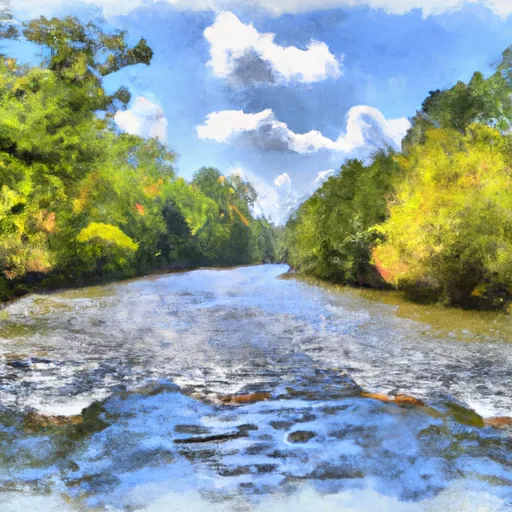
One of the most notable rapids on this river is called "Net Falls," which is a steep, technical Class IV rapid that requires precise maneuvering. Other notable rapids include "Cedar Rapids" and "S-Turns." However, the river also has sections of calm water, making it suitable for paddlers of varying skill levels.
In terms of regulations, paddlers should be aware that the East Branch Net River runs through private land, and access may be limited. It is important to obtain permission from landowners before accessing the river. Additionally, paddlers should follow Leave No Trace principles and avoid littering or damaging the natural environment.
Overall, the East Branch Net River in Illinois offers a challenging and scenic whitewater experience for paddlers, with several notable rapids and an ideal streamflow range of 100-500 cfs. Paddlers should be aware of regulations and respect private landowners.
Plan your run down to the hour
Same weather feed Snoflo's iOS app uses -- updated continuously from NOAA / yr.no. Watch the precipitation column on the meteogram; rain ahead of a run typically lifts flows 12-48 hours later depending on the basin.
Next 5 days, hour by hour
Temperature line with weather symbols on top, snow + rain accumulation as columns, humidity as a dotted line.
5-day forecast table
Every 3 hours, broken out across temperature, snow, rain, humidity, and wind. Each cell is colour-coded relative to the column min/max.
| Time | Condition | Temp (°F) | Snow (in) | Rain (in) | Humidity (%) | Wind (mps) | Wind dir |
|---|---|---|---|---|---|---|---|
| Loading detailed forecast… | |||||||
15-day temperature & precipitation
Daily temperatures, snow, and rain projected over the next two weeks -- the upstream story that drives next week's flows.
Regional streamflow levels
USGS streamgauges around East Branch Net River, From Its Source In Sec 8, T47n, R32w To Confluence With Mainstem Net River In Sec 24, T46n, R34w -- useful for spotting upstream pulses and gauging which tributary is contributing what.
| Streamgauge | Discharge | View |
|---|---|---|
| Sturgeon River Near Sidnaw | 39 cfs | → |
| Michigamme River Near Crystal Falls | 694 cfs | → |
| Iron River At County Hwy-424 At Caspian | 69 cfs | → |
| Paint River Nr Alpha | 292 cfs | → |
| Sturgeon River Near Alston | 45 cfs | → |
| Middle Branch Escanaba River At Humboldt | 98 cfs | → |
Plan a longer trip
The closest boat launches, other paddle runs, and campgrounds so a day on the water can grow into a full weekend.
Boat launches
- Fishing Site No 1 Road Hematite Township
- Net River Dam Road Covington Township
- Cable Shores Drive Hematite Township
- Deer Lake Road Crystal Falls Township
- Fishing Site No 2 Road Hematite Township
- Perch Lake Road Bates Township
Other river runs
- West Branch Net River, From Its Source In Sec 35, T48n, R34w To Confluence With Mainstem Net River In Sec 24, T46n, R34w
- Net River Mainstem, Confluence With East/West Branches To Confluence With The Mainstem Paint River
- From Wagner Lake In Sec 13, T49n, R31w To Eastern Boundary Of The Ottawa Nf In Sec 12, T48n, R35@
- Mainstem, Easternforest Boundary In Sec 1, T44n, R35w To City Of Crystal Falls
- Brule Lake In Ne1/4 Sec 15, T41n, R13e To Forest Boundary In Se1/4 Sec 31, T41n, R17e
Campgrounds
- Deer Lake State Forest Campground
- Deer Lake - State Forest
- King Lake State Forest Campground
- Perch Lake Campground
- Perch Lake
- Norway Lake
Fishing spots
Points of interest
Whitewater safety
- Check the flow before you run
- Use the linked-gauge card and Regional Flow panel above. Class ratings change with flow -- a Class III at low water can become Class IV+ at high water.
- Know your skill ceiling
- Pick runs comfortably below your ceiling. Cold-water and big-water runs raise the consequences of any mistake.
- Wear the right gear
- Helmet, PFD, drysuit / wetsuit when water is below 60°F. Throw bag, knife, and whistle on your person, not in the boat.
- Scout, set safety, and run with a team
- Scout new rapids on foot, set safety with throw bags above the consequence pool, and run with at least one other competent paddler.
- Respect the river
- Strainers, undercuts, low-head dams, and wood can kill at any class rating. When in doubt, portage.
Set push alerts in the Snoflo app
Save East Branch Net River, From Its Source In Sec 8, T47n, R32w To Confluence With Mainstem Net River In Sec 24, T46n, R34w as a favorite, set a discharge threshold (e.g. "alert me when flow hits 600 cfs"), and the iOS app pushes the moment the linked gauge crosses.
About East Branch Net River, From Its Source In Sec 8, T47n, R32w To Confluence With Mainstem Net River In Sec 24, T46n, R34w
What's the optimal flow for East Branch Net River, From Its Source In Sec 8, T47n, R32w To Confluence With Mainstem Net River In Sec 24, T46n, R34w?
The optimal flow depends on the section and the craft. Check the Run Details panel for the linked gauge and current status.
How fresh is the cfs reading on this page?
The linked USGS streamgauge reports continuously (every 15 minutes); Snoflo refreshes throughout the day. Hover the streamflow sparkline to read individual datapoints.
What's the whitewater class?
See the Run Details panel for the class rating Snoflo tracks for this run. Class ratings change with flow -- a Class III at low water can become Class IV in high water.
Where do I put in / take out?
Tap Directions in the hero above to open driving directions to the put-in. For shuttle planning, check the Nearby Boat Launches panel and the river run operator's site.
Can I get alerts when flows hit the optimal range?
Yes -- alerts are managed in the Snoflo iOS app. Favorite this run, set a discharge threshold, and you'll get a push the moment the gauge crosses.
Other runs near here
Snoflo-tracked paddle runs within driving distance of East Branch Net River, From Its Source In Sec 8, T47n, R32w To Confluence With Mainstem Net River In Sec 24, T46n, R34w.