Headwaters To Mouth At West Branch Pleasant River River Run
Community Reviews
Been here? Share the conditions.
Reviews, ratings & photos are added in the free Snoflo iOS app — rate a spot, tag the conditions, and your visit is verified by location. Add or manage your reviews from the app.
Headwaters To Mouth At West Branch Pleasant River
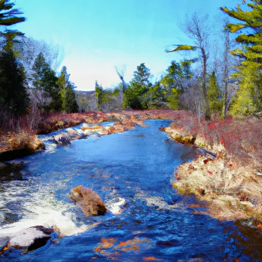
The specific river rapids and obstacles on this run include Big A rapids, which is a Class IV rapid with a large and technical drop, and Moose Island rapid, which is a Class III rapid with a narrow channel and strong currents. Other notable rapids include Eagle's Nest, Powerline, and The Ledges. Paddlers should also be aware of several portages on this run, including one around a dam at the start of the run.
There are specific regulations to the area that paddlers must follow. The Maine Department of Inland Fisheries and Wildlife requires all paddlers to have a valid Maine River Access Sticker displayed on their boat. Additionally, the state has regulations on allowable boating hours and equipment requirements, such as personal flotation devices and proper safety equipment.
Overall, the Whitewater River Run from Headwaters to Mouth at West Branch Pleasant River offers a challenging and exciting experience for experienced whitewater paddlers. With its specific regulations and technical rapids, it is important for paddlers to be prepared and knowledgeable before embarking on this adventure.
Plan your run down to the hour
Same weather feed Snoflo's iOS app uses -- updated continuously from NOAA / yr.no. Watch the precipitation column on the meteogram; rain ahead of a run typically lifts flows 12-48 hours later depending on the basin.
Next 5 days, hour by hour
Temperature line with weather symbols on top, snow + rain accumulation as columns, humidity as a dotted line.
5-day forecast table
Every 3 hours, broken out across temperature, snow, rain, humidity, and wind. Each cell is colour-coded relative to the column min/max.
| Time | Condition | Temp (°F) | Snow (in) | Rain (in) | Humidity (%) | Wind (mps) | Wind dir |
|---|---|---|---|---|---|---|---|
| Loading detailed forecast… | |||||||
15-day temperature & precipitation
Daily temperatures, snow, and rain projected over the next two weeks -- the upstream story that drives next week's flows.
Regional streamflow levels
USGS streamgauges around Headwaters To Mouth At West Branch Pleasant River -- useful for spotting upstream pulses and gauging which tributary is contributing what.
| Streamgauge | Discharge | View |
|---|---|---|
| Piscataquis River At Blanchard | 12 cfs | → |
| Piscataquis River Near Dover-Foxcroft | 48 cfs | → |
| Kingsbury Stream At Abbot Village | 15 cfs | → |
| Piscataquis River At Medford | 277 cfs | → |
| Kennebec River At The Forks | 438 cfs | → |
| East Branch Penobscot River At Grindstone | 521 cfs | → |
Plan a longer trip
The closest boat launches, other paddle runs, and campgrounds so a day on the water can grow into a full weekend.
Boat launches
- First Roach Pond
- Beaver Cove Marina
- Moosehead Lake (State Park Rowell Cove)
- Wilson Pond
- Boat Landing Road 20, Piscataquis County
- Moosehead Lake (State Park Dunn Point)
Other river runs
- Lobster Lake To Confluence With West Branch
- Ambajejus Falls To The End Of North And South Twin Lakes
- Kennebec Gorge
- Golden Road Bridge (Approx. 2 Miles Below Lobster Stream) To Confluence With Pine Stream
- Headwaters To Confluence With Penobscot River, East Branch
Whitewater safety
- Check the flow before you run
- Use the linked-gauge card and Regional Flow panel above. Class ratings change with flow -- a Class III at low water can become Class IV+ at high water.
- Know your skill ceiling
- Pick runs comfortably below your ceiling. Cold-water and big-water runs raise the consequences of any mistake.
- Wear the right gear
- Helmet, PFD, drysuit / wetsuit when water is below 60°F. Throw bag, knife, and whistle on your person, not in the boat.
- Scout, set safety, and run with a team
- Scout new rapids on foot, set safety with throw bags above the consequence pool, and run with at least one other competent paddler.
- Respect the river
- Strainers, undercuts, low-head dams, and wood can kill at any class rating. When in doubt, portage.
Set push alerts in the Snoflo app
Save Headwaters To Mouth At West Branch Pleasant River as a favorite, set a discharge threshold (e.g. "alert me when flow hits 600 cfs"), and the iOS app pushes the moment the linked gauge crosses.
About Headwaters To Mouth At West Branch Pleasant River
What's the optimal flow for Headwaters To Mouth At West Branch Pleasant River?
The optimal flow depends on the section and the craft. Check the Run Details panel for the linked gauge and current status.
How fresh is the cfs reading on this page?
The linked USGS streamgauge reports continuously (every 15 minutes); Snoflo refreshes throughout the day. Hover the streamflow sparkline to read individual datapoints.
What's the whitewater class?
See the Run Details panel for the class rating Snoflo tracks for this run. Class ratings change with flow -- a Class III at low water can become Class IV in high water.
Where do I put in / take out?
Tap Directions in the hero above to open driving directions to the put-in. For shuttle planning, check the Nearby Boat Launches panel and the river run operator's site.
Can I get alerts when flows hit the optimal range?
Yes -- alerts are managed in the Snoflo iOS app. Favorite this run, set a discharge threshold, and you'll get a push the moment the gauge crosses.
Other runs near here
Snoflo-tracked paddle runs within driving distance of Headwaters To Mouth At West Branch Pleasant River.