Mainstem, Easternforest Boundary In Sec 1, T44n, R35w To City Of Crystal Falls River Run
Community Reviews
Been here? Share the conditions.
Reviews, ratings & photos are added in the free Snoflo iOS app — rate a spot, tag the conditions, and your visit is verified by location. Add or manage your reviews from the app.
Mainstem, Easternforest Boundary In Sec 1, T44n, R35w To City Of Crystal Falls
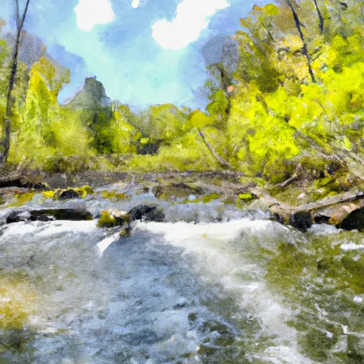
The segment begins with class I-II rapids and gradually increases in difficulty, with class III rapids towards the end. The most notable rapids on this segment are "Double Drop" and "S-Turn." These rapids offer a thrilling experience for intermediate to advanced paddlers.
One of the most notable obstacles on this segment is a dam near the end of the run. It is important to take caution as the approach to the dam can be dangerous. All paddlers are required to portage around the dam as it poses a significant risk.
The Whitewater River Run is regulated by the Michigan Department of Natural Resources. All paddlers are required to have a valid state park permit to access the river. Additionally, all paddlers must wear a personal flotation device (PFD) and carry a whistle. It is also recommended to have a throw bag and a first aid kit.
Overall, the Whitewater River Run Mainstem, Easternforest Boundary in Sec 1, T44N, R35W to City of Crystal Falls is a challenging and exciting river run. Paddlers can enjoy the scenic views and the adrenaline rush of the rapids. It is essential to follow all regulations and take the necessary precautions to ensure a safe and enjoyable experience.
Plan your run down to the hour
Same weather feed Snoflo's iOS app uses -- updated continuously from NOAA / yr.no. Watch the precipitation column on the meteogram; rain ahead of a run typically lifts flows 12-48 hours later depending on the basin.
Next 5 days, hour by hour
Temperature line with weather symbols on top, snow + rain accumulation as columns, humidity as a dotted line.
5-day forecast table
Every 3 hours, broken out across temperature, snow, rain, humidity, and wind. Each cell is colour-coded relative to the column min/max.
| Time | Condition | Temp (°F) | Snow (in) | Rain (in) | Humidity (%) | Wind (mps) | Wind dir |
|---|---|---|---|---|---|---|---|
| Loading detailed forecast… | |||||||
15-day temperature & precipitation
Daily temperatures, snow, and rain projected over the next two weeks -- the upstream story that drives next week's flows.
Regional streamflow levels
USGS streamgauges around Mainstem, Easternforest Boundary In Sec 1, T44n, R35w To City Of Crystal Falls -- useful for spotting upstream pulses and gauging which tributary is contributing what.
| Streamgauge | Discharge | View |
|---|---|---|
| Michigamme River Near Crystal Falls | 694 cfs | → |
| Paint River Nr Alpha | 292 cfs | → |
| Brule River At Us Highway 2 Near Florence | 214 cfs | → |
| Brule River Near Commonwealth | 537 cfs | → |
| Menominee River Near Florence | 875 cfs | → |
| Iron River At County Hwy-424 At Caspian | 69 cfs | → |
Plan a longer trip
The closest boat launches, other paddle runs, and campgrounds so a day on the water can grow into a full weekend.
Boat launches
- East Superior Avenue Crystal Falls
- Sheltrow Road Crystal Falls Township
- Us 2 Crystal Falls Township
- Kohon Road Crystal Falls Township
- Lake Mary Road Mastodon Township
- Long Lake Road Crystal Falls Township
Other river runs
- Brule Lake In Ne1/4 Sec 15, T41n, R13e To Forest Boundary In Se1/4 Sec 31, T41n, R17e
- Net River Mainstem, Confluence With East/West Branches To Confluence With The Mainstem Paint River
- Forest Road 2156 To Eastern Forest Boundary
- East Branch Net River, From Its Source In Sec 8, T47n, R32w To Confluence With Mainstem Net River In Sec 24, T46n, R34w
- Forest Road 2133 To Forest Road 2156
Campgrounds
- Paint River Hills Campground
- Glidden Lake State Forest Campground
- Pentoga Park (Iron County Park)
- Lake Ellen Camp
- Bates Township Park - Sunset Lake
- Newberg Township Park Campground
Fishing spots
Parks
Whitewater safety
- Check the flow before you run
- Use the linked-gauge card and Regional Flow panel above. Class ratings change with flow -- a Class III at low water can become Class IV+ at high water.
- Know your skill ceiling
- Pick runs comfortably below your ceiling. Cold-water and big-water runs raise the consequences of any mistake.
- Wear the right gear
- Helmet, PFD, drysuit / wetsuit when water is below 60°F. Throw bag, knife, and whistle on your person, not in the boat.
- Scout, set safety, and run with a team
- Scout new rapids on foot, set safety with throw bags above the consequence pool, and run with at least one other competent paddler.
- Respect the river
- Strainers, undercuts, low-head dams, and wood can kill at any class rating. When in doubt, portage.
Set push alerts in the Snoflo app
Save Mainstem, Easternforest Boundary In Sec 1, T44n, R35w To City Of Crystal Falls as a favorite, set a discharge threshold (e.g. "alert me when flow hits 600 cfs"), and the iOS app pushes the moment the linked gauge crosses.
About Mainstem, Easternforest Boundary In Sec 1, T44n, R35w To City Of Crystal Falls
What's the optimal flow for Mainstem, Easternforest Boundary In Sec 1, T44n, R35w To City Of Crystal Falls?
The optimal flow depends on the section and the craft. Check the Run Details panel for the linked gauge and current status.
How fresh is the cfs reading on this page?
The linked USGS streamgauge reports continuously (every 15 minutes); Snoflo refreshes throughout the day. Hover the streamflow sparkline to read individual datapoints.
What's the whitewater class?
See the Run Details panel for the class rating Snoflo tracks for this run. Class ratings change with flow -- a Class III at low water can become Class IV in high water.
Where do I put in / take out?
Tap Directions in the hero above to open driving directions to the put-in. For shuttle planning, check the Nearby Boat Launches panel and the river run operator's site.
Can I get alerts when flows hit the optimal range?
Yes -- alerts are managed in the Snoflo iOS app. Favorite this run, set a discharge threshold, and you'll get a push the moment the gauge crosses.
Other runs near here
Snoflo-tracked paddle runs within driving distance of Mainstem, Easternforest Boundary In Sec 1, T44n, R35w To City Of Crystal Falls.