Blanchard Dam To Ends One Mile Downstream From The Southern Village Boundary Of Rice River Run
Community Reviews
Been here? Share the conditions.
Reviews, ratings & photos are added in the free Snoflo iOS app — rate a spot, tag the conditions, and your visit is verified by location. Add or manage your reviews from the app.
Blanchard Dam To Ends One Mile Downstream From The Southern Village Boundary Of Rice
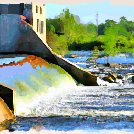
This run is rated as a Class II-III run, meaning it has moderate to difficult rapids with some obstacles that require an experienced paddler to navigate. Some of the specific rapids/obstacles on this run include "The Wave," "The Drop," and "The Pinball."
There are specific regulations that apply to this area, including a requirement to wear a personal flotation device (PFD) at all times while on the river. Additionally, camping along the riverbank is prohibited, and visitors are asked to observe a carry-in, carry-out policy when it comes to trash and other waste.
Overall, the Whitewater River Run at Blanchard Dam is a thrilling experience for experienced paddlers. Visitors should be sure to check the streamflow conditions before embarking on their journey, as the ideal range can vary depending on weather conditions.
Plan your run down to the hour
Same weather feed Snoflo's iOS app uses -- updated continuously from NOAA / yr.no. Watch the precipitation column on the meteogram; rain ahead of a run typically lifts flows 12-48 hours later depending on the basin.
Next 5 days, hour by hour
Temperature line with weather symbols on top, snow + rain accumulation as columns, humidity as a dotted line.
5-day forecast table
Every 3 hours, broken out across temperature, snow, rain, humidity, and wind. Each cell is colour-coded relative to the column min/max.
| Time | Condition | Temp (°F) | Snow (in) | Rain (in) | Humidity (%) | Wind (mps) | Wind dir |
|---|---|---|---|---|---|---|---|
| Loading detailed forecast… | |||||||
15-day temperature & precipitation
Daily temperatures, snow, and rain projected over the next two weeks -- the upstream story that drives next week's flows.
Regional streamflow levels
USGS streamgauges around Blanchard Dam To Ends One Mile Downstream From The Southern Village Boundary Of Rice -- useful for spotting upstream pulses and gauging which tributary is contributing what.
| Streamgauge | Discharge | View |
|---|---|---|
| Mississippi River Near Royalton | 2,480 cfs | → |
| Sauk River Near St. Cloud | 269 cfs | → |
| Mississippi River At St. Cloud | 3,330 cfs | → |
| Long Prairie River At Long Prairie | 125 cfs | → |
| Crow Wing River Near Pillager | 686 cfs | → |
| Mississippi River At Brainerd | 1,160 cfs | → |
Plan a longer trip
The closest boat launches, other paddle runs, and campgrounds so a day on the water can grow into a full weekend.
Boat launches
- Blanchard Dam Landing
- Royalton Sportsman's Club
- Great River Road 2199, Little Falls
- County Road 256
- Rice/Skunk Lake
- Le Bourget Park
Other river runs
- The Beaver Islands At St. Cloud To The Confluence Of The Clearwater River
- The 25-Acre Island Just South Of Brainerd To Roscoe Island
- The Confluence Of The Clearwater River To The Northwestern Corporate Boundary Of Anoka
- The Discharge Of The Flood Diversion Channel To Riverton
- The Site Of Old Sandstone Hydroelectric Dam To The Confluence With St. Croix River
Campgrounds
- Charles A Lindbergh State Park
- Charles Lindbergh State Park
- Charles A. Lindbergh State Park Group Site
- Veterans Memorial Park Campgrounds
- Benton Beach Campground
- Benton Beach
Parks
Whitewater safety
- Check the flow before you run
- Use the linked-gauge card and Regional Flow panel above. Class ratings change with flow -- a Class III at low water can become Class IV+ at high water.
- Know your skill ceiling
- Pick runs comfortably below your ceiling. Cold-water and big-water runs raise the consequences of any mistake.
- Wear the right gear
- Helmet, PFD, drysuit / wetsuit when water is below 60°F. Throw bag, knife, and whistle on your person, not in the boat.
- Scout, set safety, and run with a team
- Scout new rapids on foot, set safety with throw bags above the consequence pool, and run with at least one other competent paddler.
- Respect the river
- Strainers, undercuts, low-head dams, and wood can kill at any class rating. When in doubt, portage.
Set push alerts in the Snoflo app
Save Blanchard Dam To Ends One Mile Downstream From The Southern Village Boundary Of Rice as a favorite, set a discharge threshold (e.g. "alert me when flow hits 600 cfs"), and the iOS app pushes the moment the linked gauge crosses.
About Blanchard Dam To Ends One Mile Downstream From The Southern Village Boundary Of Rice
What's the optimal flow for Blanchard Dam To Ends One Mile Downstream From The Southern Village Boundary Of Rice ?
The optimal flow depends on the section and the craft. Check the Run Details panel for the linked gauge and current status.
How fresh is the cfs reading on this page?
The linked USGS streamgauge reports continuously (every 15 minutes); Snoflo refreshes throughout the day. Hover the streamflow sparkline to read individual datapoints.
What's the whitewater class?
See the Run Details panel for the class rating Snoflo tracks for this run. Class ratings change with flow -- a Class III at low water can become Class IV in high water.
Where do I put in / take out?
Tap Directions in the hero above to open driving directions to the put-in. For shuttle planning, check the Nearby Boat Launches panel and the river run operator's site.
Can I get alerts when flows hit the optimal range?
Yes -- alerts are managed in the Snoflo iOS app. Favorite this run, set a discharge threshold, and you'll get a push the moment the gauge crosses.
Other runs near here
Snoflo-tracked paddle runs within driving distance of Blanchard Dam To Ends One Mile Downstream From The Southern Village Boundary Of Rice .