Morrell Falls, Sec. 24, T18n, R15w To Morrell Falls Trailhead, Sec. 36, T18n, R15w River Run
Community Reviews
Been here? Share the conditions.
Reviews, ratings & photos are added in the free Snoflo iOS app — rate a spot, tag the conditions, and your visit is verified by location. Add or manage your reviews from the app.
Morrell Falls, Sec. 24, T18n, R15w To Morrell Falls Trailhead, Sec. 36, T18n, R15w
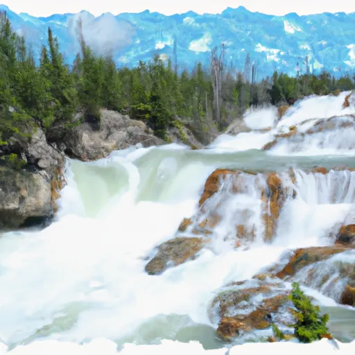
According to American Whitewater, the Morrell Falls run is a popular destination for intermediate paddlers looking for a scenic and challenging run. The "Toilet Bowl" rapid is a notable feature on this route, requiring precise boat control and maneuvering skills. The "Boulder Garden" section also poses a challenge, with large boulders creating technical rapids and hydraulics.
The ideal streamflow range for this run is based on the average water levels during the summer months. As with any whitewater run, water levels can fluctuate due to weather conditions and other factors, so it is important to monitor current water levels before embarking on this run.
Overall, the Whitewater River run from Morrell Falls offers a challenging and scenic adventure for intermediate paddlers. It is advised to check with local authorities for any specific regulations or seasonal closures before planning a trip to this area.
Plan your run down to the hour
Same weather feed Snoflo's iOS app uses -- updated continuously from NOAA / yr.no. Watch the precipitation column on the meteogram; rain ahead of a run typically lifts flows 12-48 hours later depending on the basin.
Next 5 days, hour by hour
Temperature line with weather symbols on top, snow + rain accumulation as columns, humidity as a dotted line.
5-day forecast table
Every 3 hours, broken out across temperature, snow, rain, humidity, and wind. Each cell is colour-coded relative to the column min/max.
| Time | Condition | Temp (°F) | Snow (in) | Rain (in) | Humidity (%) | Wind (mps) | Wind dir |
|---|---|---|---|---|---|---|---|
| Loading detailed forecast… | |||||||
15-day temperature & precipitation
Daily temperatures, snow, and rain projected over the next two weeks -- the upstream story that drives next week's flows.
Regional streamflow levels
USGS streamgauges around Morrell Falls, Sec. 24, T18n, R15w To Morrell Falls Trailhead, Sec. 36, T18n, R15w -- useful for spotting upstream pulses and gauging which tributary is contributing what.
| Streamgauge | Discharge | View |
|---|---|---|
| South Fork Jocko River Near Arlee Mt | 51 cfs | → |
| Mission Cr Ab Reservoir Nr St Ignatius Mt | 104 cfs | → |
| Nf Blackfoot R Ab Dry Gulch Nr Ovando Mt | 328 cfs | → |
| Blackfoot River Near Bonner Mt | 1,000 cfs | → |
| South Crow Creek Near Ronan Mt | 9 cfs | → |
| Blackfoot R Ab Nevada Cr Nr Helmville Mt | 347 cfs | → |
Plan a longer trip
The closest boat launches, other paddle runs, and campgrounds so a day on the water can grow into a full weekend.
Boat launches
- Placid Lake State Park
- Salmon Lake State Park
- South Holland Lake Road 232, 59826 Montana
- Upsata Lake
- Harpers Lake
- Russell Gates Memorial
Other river runs
- Headwaters, Sec. 7, T18n, R14w To Morrell Falls, Sec. 24, T18n, R15w
- Headwaters, Sec. 17, T19n, R15w To Seeley Lake, Sec. 20, T17n, R15w
- Blackfoot River
- Belmont Creek
Campgrounds
- Lake Inez Campground
- Lake Inez
- Lakeside (Old Alva)
- Big Larch Complex
- Big Larch Campground
- Seeley Lake Complex
Fishing spots
Whitewater safety
- Check the flow before you run
- Use the linked-gauge card and Regional Flow panel above. Class ratings change with flow -- a Class III at low water can become Class IV+ at high water.
- Know your skill ceiling
- Pick runs comfortably below your ceiling. Cold-water and big-water runs raise the consequences of any mistake.
- Wear the right gear
- Helmet, PFD, drysuit / wetsuit when water is below 60°F. Throw bag, knife, and whistle on your person, not in the boat.
- Scout, set safety, and run with a team
- Scout new rapids on foot, set safety with throw bags above the consequence pool, and run with at least one other competent paddler.
- Respect the river
- Strainers, undercuts, low-head dams, and wood can kill at any class rating. When in doubt, portage.
Set push alerts in the Snoflo app
Save Morrell Falls, Sec. 24, T18n, R15w To Morrell Falls Trailhead, Sec. 36, T18n, R15w as a favorite, set a discharge threshold (e.g. "alert me when flow hits 600 cfs"), and the iOS app pushes the moment the linked gauge crosses.
About Morrell Falls, Sec. 24, T18n, R15w To Morrell Falls Trailhead, Sec. 36, T18n, R15w
What's the optimal flow for Morrell Falls, Sec. 24, T18n, R15w To Morrell Falls Trailhead, Sec. 36, T18n, R15w?
The optimal flow depends on the section and the craft. Check the Run Details panel for the linked gauge and current status.
How fresh is the cfs reading on this page?
The linked USGS streamgauge reports continuously (every 15 minutes); Snoflo refreshes throughout the day. Hover the streamflow sparkline to read individual datapoints.
What's the whitewater class?
See the Run Details panel for the class rating Snoflo tracks for this run. Class ratings change with flow -- a Class III at low water can become Class IV in high water.
Where do I put in / take out?
Tap Directions in the hero above to open driving directions to the put-in. For shuttle planning, check the Nearby Boat Launches panel and the river run operator's site.
Can I get alerts when flows hit the optimal range?
Yes -- alerts are managed in the Snoflo iOS app. Favorite this run, set a discharge threshold, and you'll get a push the moment the gauge crosses.
Other runs near here
Snoflo-tracked paddle runs within driving distance of Morrell Falls, Sec. 24, T18n, R15w To Morrell Falls Trailhead, Sec. 36, T18n, R15w.