Beaverhead Boundary, Sec. 22, T9s, R3w To South Of Romy Lake, Sec. 26, T8s, R3w River Run
Community Reviews
Been here? Share the conditions.
Reviews, ratings & photos are added in the free Snoflo iOS app — rate a spot, tag the conditions, and your visit is verified by location. Add or manage your reviews from the app.
Beaverhead Boundary, Sec. 22, T9s, R3w To South Of Romy Lake, Sec. 26, T8s, R3w
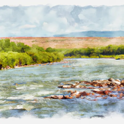
The Beaverhead River offers a variety of rapids and obstacles such as S-Turn, Beaver Slide, and Rattlesnake, which are all popular among experienced rafters. The river also has numerous fishing opportunities, with brown and rainbow trout being the most commonly found.
Regulations for the Beaverhead River include mandatory life jackets for all participants and a maximum group size of 12 people per trip. There are also specific rules in place for fishing, including catch and release-only for rainbow trout and a limit of one brown trout per day.
Overall, the Beaverhead River run from Beaverhead Boundary to South of Romy Lake is an excellent option for rafters of all skill levels and offers a unique Montana wilderness experience.
Plan your run down to the hour
Same weather feed Snoflo's iOS app uses -- updated continuously from NOAA / yr.no. Watch the precipitation column on the meteogram; rain ahead of a run typically lifts flows 12-48 hours later depending on the basin.
Next 5 days, hour by hour
Temperature line with weather symbols on top, snow + rain accumulation as columns, humidity as a dotted line.
5-day forecast table
Every 3 hours, broken out across temperature, snow, rain, humidity, and wind. Each cell is colour-coded relative to the column min/max.
| Time | Condition | Temp (°F) | Snow (in) | Rain (in) | Humidity (%) | Wind (mps) | Wind dir |
|---|---|---|---|---|---|---|---|
| Loading detailed forecast… | |||||||
15-day temperature & precipitation
Daily temperatures, snow, and rain projected over the next two weeks -- the upstream story that drives next week's flows.
Regional streamflow levels
USGS streamgauges around Beaverhead Boundary, Sec. 22, T9s, R3w To South Of Romy Lake, Sec. 26, T8s, R3w -- useful for spotting upstream pulses and gauging which tributary is contributing what.
| Streamgauge | Discharge | View |
|---|---|---|
| Ruby River Ab Reservoir Nr Alder Mt | 101 cfs | → |
| Ruby River Bl Reservoir Nr Alder Mt | 207 cfs | → |
| Madison River Near Cameron Mt | 1,660 cfs | → |
| Madison River At Kirby Ranch Nr Cameron Mt | 1,570 cfs | → |
| Madison River Bl Hebgen Lake Nr Grayling Mt | 1,440 cfs | → |
| Red Rock Cr Ab Lakes Nr Lakeview Mt | 31 cfs | → |
Plan a longer trip
The closest boat launches, other paddle runs, and campgrounds so a day on the water can grow into a full weekend.
Boat launches
- Ruby Creek Boat Launch
- Mcatee Bridge Madison County
- Mcatee Bridge
- Palisades Day Use
- Madison County
- Storey Ditch Boat Launch
Campgrounds
- Vigilante Cabin
- Clover Meadows Dispersed Camping And Picnic Area
- Black Butte Cabin
- Wall Creek Cabin
- Ruby Creek Campground
- Ruby Reservoir Rec Site
Fishing spots
Whitewater safety
- Check the flow before you run
- Use the linked-gauge card and Regional Flow panel above. Class ratings change with flow -- a Class III at low water can become Class IV+ at high water.
- Know your skill ceiling
- Pick runs comfortably below your ceiling. Cold-water and big-water runs raise the consequences of any mistake.
- Wear the right gear
- Helmet, PFD, drysuit / wetsuit when water is below 60°F. Throw bag, knife, and whistle on your person, not in the boat.
- Scout, set safety, and run with a team
- Scout new rapids on foot, set safety with throw bags above the consequence pool, and run with at least one other competent paddler.
- Respect the river
- Strainers, undercuts, low-head dams, and wood can kill at any class rating. When in doubt, portage.
Set push alerts in the Snoflo app
Save Beaverhead Boundary, Sec. 22, T9s, R3w To South Of Romy Lake, Sec. 26, T8s, R3w as a favorite, set a discharge threshold (e.g. "alert me when flow hits 600 cfs"), and the iOS app pushes the moment the linked gauge crosses.
About Beaverhead Boundary, Sec. 22, T9s, R3w To South Of Romy Lake, Sec. 26, T8s, R3w
What's the optimal flow for Beaverhead Boundary, Sec. 22, T9s, R3w To South Of Romy Lake, Sec. 26, T8s, R3w?
The optimal flow depends on the section and the craft. Check the Run Details panel for the linked gauge and current status.
How fresh is the cfs reading on this page?
The linked USGS streamgauge reports continuously (every 15 minutes); Snoflo refreshes throughout the day. Hover the streamflow sparkline to read individual datapoints.
What's the whitewater class?
See the Run Details panel for the class rating Snoflo tracks for this run. Class ratings change with flow -- a Class III at low water can become Class IV in high water.
Where do I put in / take out?
Tap Directions in the hero above to open driving directions to the put-in. For shuttle planning, check the Nearby Boat Launches panel and the river run operator's site.
Can I get alerts when flows hit the optimal range?
Yes -- alerts are managed in the Snoflo iOS app. Favorite this run, set a discharge threshold, and you'll get a push the moment the gauge crosses.
Other runs near here
Snoflo-tracked paddle runs within driving distance of Beaverhead Boundary, Sec. 22, T9s, R3w To South Of Romy Lake, Sec. 26, T8s, R3w.