Gallatin Forest Boundary, Sec. 26, T3s, R12e To Blakley Creek, Sec. 26, T3s, R12e River Run
Community Reviews
Been here? Share the conditions.
Reviews, ratings & photos are added in the free Snoflo iOS app — rate a spot, tag the conditions, and your visit is verified by location. Add or manage your reviews from the app.
Gallatin Forest Boundary, Sec. 26, T3s, R12e To Blakley Creek, Sec. 26, T3s, R12e
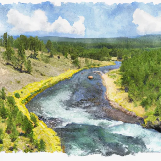
In addition to the rapids, there are also potential hazards such as strainers and sweepers, which require careful navigation. It is recommended that only experienced whitewater paddlers attempt this run.
Specific regulations for the Gallatin River include a limit on the number of commercial river users, and a requirement for all boaters to wear personal flotation devices (PFDs). The river is also subject to seasonal closures and restrictions to protect fish populations.
Overall, the Gallatin Forest Boundary to Blakley Creek run is a challenging and exciting whitewater experience, but should only be attempted by experienced paddlers with appropriate equipment and caution.
Plan your run down to the hour
Same weather feed Snoflo's iOS app uses -- updated continuously from NOAA / yr.no. Watch the precipitation column on the meteogram; rain ahead of a run typically lifts flows 12-48 hours later depending on the basin.
Next 5 days, hour by hour
Temperature line with weather symbols on top, snow + rain accumulation as columns, humidity as a dotted line.
5-day forecast table
Every 3 hours, broken out across temperature, snow, rain, humidity, and wind. Each cell is colour-coded relative to the column min/max.
| Time | Condition | Temp (°F) | Snow (in) | Rain (in) | Humidity (%) | Wind (mps) | Wind dir |
|---|---|---|---|---|---|---|---|
| Loading detailed forecast… | |||||||
15-day temperature & precipitation
Daily temperatures, snow, and rain projected over the next two weeks -- the upstream story that drives next week's flows.
Regional streamflow levels
USGS streamgauges around Gallatin Forest Boundary, Sec. 26, T3s, R12e To Blakley Creek, Sec. 26, T3s, R12e -- useful for spotting upstream pulses and gauging which tributary is contributing what.
| Streamgauge | Discharge | View |
|---|---|---|
| Yellowstone River Near Livingston Mt | 3,450 cfs | → |
| Shields River Nr Livingston Mt | 119 cfs | → |
| Boulder River At Big Timber Mt | 274 cfs | → |
| West Rosebud Creek Near Roscoe Mt | 402 cfs | → |
| Soda Butte Cr At Park Bndry At Silver Gate | 54 cfs | → |
| Stillwater River Near Absarokee Mt | 1,430 cfs | → |
Plan a longer trip
The closest boat launches, other paddle runs, and campgrounds so a day on the water can grow into a full weekend.
Boat launches
- Park County
- Springdale Bridge
- Sheep Mountain
- Us 89 Park County
- Grey Bear
- North Yellowstone Trail Road Sweet Grass County
Other river runs
- Blakley Creek, Sec. 26, T4s, R12e To Miller Creek, Sec 13, T4s, R21e
- Miller Creek, Sec. 13, T4s, R21e To Bramble Creek, Sec. 26, T5s, R12e
- Bible Run
- Bramble Creek, Sec. 26, T5s, R12e To Absaroka-Beartooth Wilderness, Sec. 22, T7s, R12e
- Custer Forest Boundary, Sec. 15, T5s, R15e To Absaroka-Beartooth Wilderness Boundary
Campgrounds
- East Boulder Campground
- East Boulder - Dispersed
- Falls Creek
- West Boulder
- West Boulder Campground
- West Boulder Cabin
Fishing spots
Whitewater safety
- Check the flow before you run
- Use the linked-gauge card and Regional Flow panel above. Class ratings change with flow -- a Class III at low water can become Class IV+ at high water.
- Know your skill ceiling
- Pick runs comfortably below your ceiling. Cold-water and big-water runs raise the consequences of any mistake.
- Wear the right gear
- Helmet, PFD, drysuit / wetsuit when water is below 60°F. Throw bag, knife, and whistle on your person, not in the boat.
- Scout, set safety, and run with a team
- Scout new rapids on foot, set safety with throw bags above the consequence pool, and run with at least one other competent paddler.
- Respect the river
- Strainers, undercuts, low-head dams, and wood can kill at any class rating. When in doubt, portage.
Set push alerts in the Snoflo app
Save Gallatin Forest Boundary, Sec. 26, T3s, R12e To Blakley Creek, Sec. 26, T3s, R12e as a favorite, set a discharge threshold (e.g. "alert me when flow hits 600 cfs"), and the iOS app pushes the moment the linked gauge crosses.
About Gallatin Forest Boundary, Sec. 26, T3s, R12e To Blakley Creek, Sec. 26, T3s, R12e
What's the optimal flow for Gallatin Forest Boundary, Sec. 26, T3s, R12e To Blakley Creek, Sec. 26, T3s, R12e?
The optimal flow depends on the section and the craft. Check the Run Details panel for the linked gauge and current status.
How fresh is the cfs reading on this page?
The linked USGS streamgauge reports continuously (every 15 minutes); Snoflo refreshes throughout the day. Hover the streamflow sparkline to read individual datapoints.
What's the whitewater class?
See the Run Details panel for the class rating Snoflo tracks for this run. Class ratings change with flow -- a Class III at low water can become Class IV in high water.
Where do I put in / take out?
Tap Directions in the hero above to open driving directions to the put-in. For shuttle planning, check the Nearby Boat Launches panel and the river run operator's site.
Can I get alerts when flows hit the optimal range?
Yes -- alerts are managed in the Snoflo iOS app. Favorite this run, set a discharge threshold, and you'll get a push the moment the gauge crosses.
Other runs near here
Snoflo-tracked paddle runs within driving distance of Gallatin Forest Boundary, Sec. 26, T3s, R12e To Blakley Creek, Sec. 26, T3s, R12e.