Vermilion River River Run
Community Reviews
Been here? Share the conditions.
Reviews, ratings & photos are added in the free Snoflo iOS app — rate a spot, tag the conditions, and your visit is verified by location. Add or manage your reviews from the app.
Vermilion River
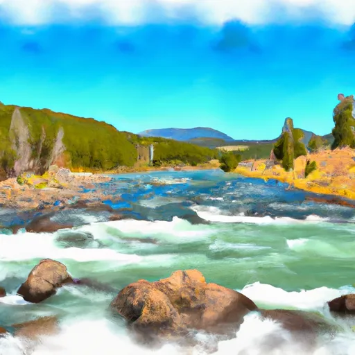
In addition to its thrilling rapids, the Vermilion River is located in a remote area with stunning natural scenery. The river runs through the Absaroka-Beartooth Wilderness, providing kayakers and rafters with incredible views of mountains, forests, and wildlife.
To protect this wilderness area, there are specific regulations that kayakers and rafters must follow. The use of motorized boats is prohibited, and permits are required for all overnight trips. There are also restrictions on group size and camping locations. Kayakers and rafters should always respect the natural environment and leave no trace of their visit.
Overall, the Whitewater River run on the Vermilion River is a challenging adventure that rewards experienced paddlers with incredible scenery and technical rapids. However, it is important to follow regulations and safety protocols to protect this beautiful wilderness area.
Plan your run down to the hour
Same weather feed Snoflo's iOS app uses -- updated continuously from NOAA / yr.no. Watch the precipitation column on the meteogram; rain ahead of a run typically lifts flows 12-48 hours later depending on the basin.
Next 5 days, hour by hour
Temperature line with weather symbols on top, snow + rain accumulation as columns, humidity as a dotted line.
5-day forecast table
Every 3 hours, broken out across temperature, snow, rain, humidity, and wind. Each cell is colour-coded relative to the column min/max.
| Time | Condition | Temp (°F) | Snow (in) | Rain (in) | Humidity (%) | Wind (mps) | Wind dir |
|---|---|---|---|---|---|---|---|
| Loading detailed forecast… | |||||||
15-day temperature & precipitation
Daily temperatures, snow, and rain projected over the next two weeks -- the upstream story that drives next week's flows.
Regional streamflow levels
USGS streamgauges around Vermilion River -- useful for spotting upstream pulses and gauging which tributary is contributing what.
| Streamgauge | Discharge | View |
|---|---|---|
| Thompson River Near Thompson Falls Mt | 213 cfs | → |
| Prospect Creek At Thompson Falls Mt | 74 cfs | → |
| Mill Cr Ab Bassoo Cr Nr Niarada Mt | 2 cfs | → |
| Clark Fork Near Plains Mt | 13,200 cfs | → |
| St. Regis River Near St. Regis | 119 cfs | → |
| Clark Fork At St. Regis Mt | 4,230 cfs | → |
Plan a longer trip
The closest boat launches, other paddle runs, and campgrounds so a day on the water can grow into a full weekend.
Boat launches
- Flatiron Ridge
- Thompson Falls State Recreation Area
- Thompson Falls
- Trout Creek
- Mckay Landing
- North Shore Road Trout Creek;Trout Creek Post Office
Other river runs
- Willow Creek, Sec. 32, T24n, R29w To Noxon Reservoir, Sec. 14, T24n, R31w
- East Fork Bull River, Headwaters, Sec. 13, T27n, R32w To Cabinet Mountains Wilderness Boundary, Sec. 3, T27n, R32w
- Boundary Proposed Addition Cabinet Mtns Wilderness, Sec. To Cabinet Gorge Reservoir
- Cabinet Mtns Wilderness Boundary, Sec. 3, T27n, R32w To Bull River, Sec. 12, T27n, R33w
- Slowery, Sec. 15, T17n, R27w To Sec. 31, T18n. R28w
Whitewater safety
- Check the flow before you run
- Use the linked-gauge card and Regional Flow panel above. Class ratings change with flow -- a Class III at low water can become Class IV+ at high water.
- Know your skill ceiling
- Pick runs comfortably below your ceiling. Cold-water and big-water runs raise the consequences of any mistake.
- Wear the right gear
- Helmet, PFD, drysuit / wetsuit when water is below 60°F. Throw bag, knife, and whistle on your person, not in the boat.
- Scout, set safety, and run with a team
- Scout new rapids on foot, set safety with throw bags above the consequence pool, and run with at least one other competent paddler.
- Respect the river
- Strainers, undercuts, low-head dams, and wood can kill at any class rating. When in doubt, portage.
Set push alerts in the Snoflo app
Save Vermilion River as a favorite, set a discharge threshold (e.g. "alert me when flow hits 600 cfs"), and the iOS app pushes the moment the linked gauge crosses.
About Vermilion River
What's the optimal flow for Vermilion River?
The optimal flow depends on the section and the craft. Check the Run Details panel for the linked gauge and current status.
How fresh is the cfs reading on this page?
The linked USGS streamgauge reports continuously (every 15 minutes); Snoflo refreshes throughout the day. Hover the streamflow sparkline to read individual datapoints.
What's the whitewater class?
See the Run Details panel for the class rating Snoflo tracks for this run. Class ratings change with flow -- a Class III at low water can become Class IV in high water.
Where do I put in / take out?
Tap Directions in the hero above to open driving directions to the put-in. For shuttle planning, check the Nearby Boat Launches panel and the river run operator's site.
Can I get alerts when flows hit the optimal range?
Yes -- alerts are managed in the Snoflo iOS app. Favorite this run, set a discharge threshold, and you'll get a push the moment the gauge crosses.
Other runs near here
Snoflo-tracked paddle runs within driving distance of Vermilion River.