Chief Joseph Cg, Sec. 28, T9s, R15e To Montana State Line, Sec. 34, T9s, R15e River Run
Community Reviews
Been here? Share the conditions.
Reviews, ratings & photos are added in the free Snoflo iOS app — rate a spot, tag the conditions, and your visit is verified by location. Add or manage your reviews from the app.
Chief Joseph Cg, Sec. 28, T9s, R15e To Montana State Line, Sec. 34, T9s, R15e
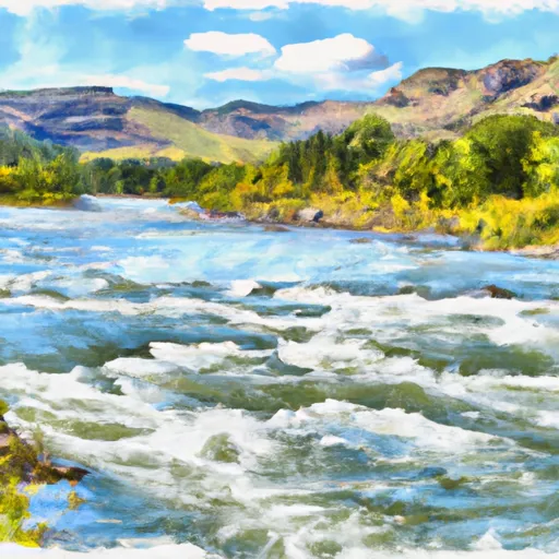
The segment mileage for this run is approximately 9 miles, with a number of notable rapids and obstacles along the way. Some of these include The Notch, a narrow chute with a sharp turn and a steep drop, and Pinball, a series of boulder gardens and drops that require skilled maneuvering. Other notable rapids include Bodacious Boulders, The Kitchen Sink, and Jaws.
There are specific regulations and guidelines that must be followed when visiting this area, including the need to obtain a permit for overnight camping. Additionally, visitors are advised to bring adequate safety gear, including helmets and personal flotation devices, and to be aware of potential hazards such as strainers and undercut rocks.
Overall, the Whitewater River Run is a challenging and exhilarating experience for experienced kayakers and rafters, offering stunning scenery and thrilling rapids. However, it is important to approach the run with caution and to follow all safety guidelines and regulations to ensure a safe and enjoyable trip.
Plan your run down to the hour
Same weather feed Snoflo's iOS app uses -- updated continuously from NOAA / yr.no. Watch the precipitation column on the meteogram; rain ahead of a run typically lifts flows 12-48 hours later depending on the basin.
Next 5 days, hour by hour
Temperature line with weather symbols on top, snow + rain accumulation as columns, humidity as a dotted line.
5-day forecast table
Every 3 hours, broken out across temperature, snow, rain, humidity, and wind. Each cell is colour-coded relative to the column min/max.
| Time | Condition | Temp (°F) | Snow (in) | Rain (in) | Humidity (%) | Wind (mps) | Wind dir |
|---|---|---|---|---|---|---|---|
| Loading detailed forecast… | |||||||
15-day temperature & precipitation
Daily temperatures, snow, and rain projected over the next two weeks -- the upstream story that drives next week's flows.
Regional streamflow levels
USGS streamgauges around Chief Joseph Cg, Sec. 28, T9s, R15e To Montana State Line, Sec. 34, T9s, R15e -- useful for spotting upstream pulses and gauging which tributary is contributing what.
| Streamgauge | Discharge | View |
|---|---|---|
| Soda Butte Cr At Park Bndry At Silver Gate | 49 cfs | → |
| West Rosebud Creek Near Roscoe Mt | 375 cfs | → |
| Rock Creek Near Red Lodge Mt | 390 cfs | → |
| Lamar River Nr Tower Falls Ranger Station Ynp | 391 cfs | → |
| Clarks Fork Yellowstone River Nr Belfry Mt | 1,210 cfs | → |
| Yellowstone River At Yellowstone Lk Outlet Ynp | 2,420 cfs | → |
Plan a longer trip
The closest boat launches, other paddle runs, and campgrounds so a day on the water can grow into a full weekend.
Boat launches
Other river runs
- Northeast Yellowstone National Park Boundary, Near Cooke City To The Confluence With Lamar River
- Absaroka-Beartooth Wilderness Boundary To Headwaters, Sec. 29, T7s, R15e
- Absaroka-Beartooth Wilderness Boundary To Headwaters, Sec. 20, T9s, R17e
- The Headwaters To Ends Above Slough Creek Campground, Located On A Secondary Spur Road To The Park's Main Road
- Absaroka-Beartooth Wilderness Boundary To Headwaters, Sec. 25, T8s, R17e
Campgrounds
- Fox Creek Campground - Closed
- Colter Campground
- Soda Butte Campground
- Crazy Creek Campground (Usfs)
- Lily Lake Camping Area
- 3c4
Fishing spots
Parks
Whitewater safety
- Check the flow before you run
- Use the linked-gauge card and Regional Flow panel above. Class ratings change with flow -- a Class III at low water can become Class IV+ at high water.
- Know your skill ceiling
- Pick runs comfortably below your ceiling. Cold-water and big-water runs raise the consequences of any mistake.
- Wear the right gear
- Helmet, PFD, drysuit / wetsuit when water is below 60°F. Throw bag, knife, and whistle on your person, not in the boat.
- Scout, set safety, and run with a team
- Scout new rapids on foot, set safety with throw bags above the consequence pool, and run with at least one other competent paddler.
- Respect the river
- Strainers, undercuts, low-head dams, and wood can kill at any class rating. When in doubt, portage.
Set push alerts in the Snoflo app
Save Chief Joseph Cg, Sec. 28, T9s, R15e To Montana State Line, Sec. 34, T9s, R15e as a favorite, set a discharge threshold (e.g. "alert me when flow hits 600 cfs"), and the iOS app pushes the moment the linked gauge crosses.
About Chief Joseph Cg, Sec. 28, T9s, R15e To Montana State Line, Sec. 34, T9s, R15e
What's the optimal flow for Chief Joseph Cg, Sec. 28, T9s, R15e To Montana State Line, Sec. 34, T9s, R15e?
The optimal flow depends on the section and the craft. Check the Run Details panel for the linked gauge and current status.
How fresh is the cfs reading on this page?
The linked USGS streamgauge reports continuously (every 15 minutes); Snoflo refreshes throughout the day. Hover the streamflow sparkline to read individual datapoints.
What's the whitewater class?
See the Run Details panel for the class rating Snoflo tracks for this run. Class ratings change with flow -- a Class III at low water can become Class IV in high water.
Where do I put in / take out?
Tap Directions in the hero above to open driving directions to the put-in. For shuttle planning, check the Nearby Boat Launches panel and the river run operator's site.
Can I get alerts when flows hit the optimal range?
Yes -- alerts are managed in the Snoflo iOS app. Favorite this run, set a discharge threshold, and you'll get a push the moment the gauge crosses.
Other runs near here
Snoflo-tracked paddle runs within driving distance of Chief Joseph Cg, Sec. 28, T9s, R15e To Montana State Line, Sec. 34, T9s, R15e.