Headwaters To Forest Boundary River Run
Community Reviews
Been here? Share the conditions.
Reviews, ratings & photos are added in the free Snoflo iOS app — rate a spot, tag the conditions, and your visit is verified by location. Add or manage your reviews from the app.
Headwaters To Forest Boundary
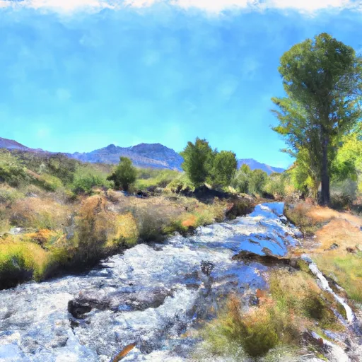
Some of the specific rapids and obstacles that paddlers will encounter during their run include the California Slide, a class III rapid that requires precise navigation, and the Windy Hole, a class II rapid known for its strong eddies. Paddlers should also be aware of the river's rocky bottom and narrow channels.
In terms of regulations, paddlers are required to obtain a permit from the Bureau of Land Management before launching on this section of the river. Additionally, camping is only allowed at designated campsites and all trash must be packed out. These regulations are in place to ensure the preservation of the natural surroundings and to minimize the impact of human activities on the river and its ecosystem.
Overall, the Headwaters to Forest Boundary section of the Whitewater River offers a thrilling and challenging experience for whitewater enthusiasts, with its ideal streamflow range, class rating, and specific rapids and obstacles. However, it is important for paddlers to abide by the regulations in place to ensure the long-term sustainability of this valuable natural resource.
Plan your run down to the hour
Same weather feed Snoflo's iOS app uses -- updated continuously from NOAA / yr.no. Watch the precipitation column on the meteogram; rain ahead of a run typically lifts flows 12-48 hours later depending on the basin.
Next 5 days, hour by hour
Temperature line with weather symbols on top, snow + rain accumulation as columns, humidity as a dotted line.
5-day forecast table
Every 3 hours, broken out across temperature, snow, rain, humidity, and wind. Each cell is colour-coded relative to the column min/max.
| Time | Condition | Temp (°F) | Snow (in) | Rain (in) | Humidity (%) | Wind (mps) | Wind dir |
|---|---|---|---|---|---|---|---|
| Loading detailed forecast… | |||||||
15-day temperature & precipitation
Daily temperatures, snow, and rain projected over the next two weeks -- the upstream story that drives next week's flows.
Regional streamflow levels
USGS streamgauges around Headwaters To Forest Boundary -- useful for spotting upstream pulses and gauging which tributary is contributing what.
| Streamgauge | Discharge | View |
|---|---|---|
| S Twin R Nr Round Mountain | 2 cfs | → |
| Kingston C Bl Cougar Canyon Nr Austin | 9 cfs | → |
| Walker R At Lateral 2-A Siphon Nr Schurz | 18 cfs | → |
| Stillwater Point Reservoir Div Canal Nr Fallon Nv | 6 cfs | → |
| Canal No 1 Blw Little Dam Nr Schurz | 20 cfs | → |
| Canal No 2 Abv Little Dam Nr Schurz | 12 cfs | → |
Plan a longer trip
The closest boat launches, other paddle runs, and campgrounds so a day on the water can grow into a full weekend.
Whitewater safety
- Check the flow before you run
- Use the linked-gauge card and Regional Flow panel above. Class ratings change with flow -- a Class III at low water can become Class IV+ at high water.
- Know your skill ceiling
- Pick runs comfortably below your ceiling. Cold-water and big-water runs raise the consequences of any mistake.
- Wear the right gear
- Helmet, PFD, drysuit / wetsuit when water is below 60°F. Throw bag, knife, and whistle on your person, not in the boat.
- Scout, set safety, and run with a team
- Scout new rapids on foot, set safety with throw bags above the consequence pool, and run with at least one other competent paddler.
- Respect the river
- Strainers, undercuts, low-head dams, and wood can kill at any class rating. When in doubt, portage.
Set push alerts in the Snoflo app
Save Headwaters To Forest Boundary as a favorite, set a discharge threshold (e.g. "alert me when flow hits 600 cfs"), and the iOS app pushes the moment the linked gauge crosses.
About Headwaters To Forest Boundary
What's the optimal flow for Headwaters To Forest Boundary?
The optimal flow depends on the section and the craft. Check the Run Details panel for the linked gauge and current status.
How fresh is the cfs reading on this page?
The linked USGS streamgauge reports continuously (every 15 minutes); Snoflo refreshes throughout the day. Hover the streamflow sparkline to read individual datapoints.
What's the whitewater class?
See the Run Details panel for the class rating Snoflo tracks for this run. Class ratings change with flow -- a Class III at low water can become Class IV in high water.
Where do I put in / take out?
Tap Directions in the hero above to open driving directions to the put-in. For shuttle planning, check the Nearby Boat Launches panel and the river run operator's site.
Can I get alerts when flows hit the optimal range?
Yes -- alerts are managed in the Snoflo iOS app. Favorite this run, set a discharge threshold, and you'll get a push the moment the gauge crosses.
Other runs near here
Snoflo-tracked paddle runs within driving distance of Headwaters To Forest Boundary.