Headwaters To Comanche Creek River Run
Community Reviews
Been here? Share the conditions.
Reviews, ratings & photos are added in the free Snoflo iOS app — rate a spot, tag the conditions, and your visit is verified by location. Add or manage your reviews from the app.
Headwaters To Comanche Creek
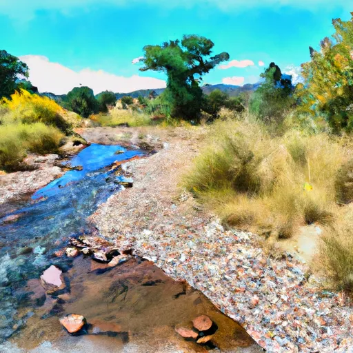
The segment mileage for this run is approximately 9 miles. Paddlers will encounter several challenging rapids, including Pinball, Souse Hole, and Red Wall. Pinball is a technical rapid with multiple rocks and eddies that require precise maneuvering. Souse Hole is a powerful hydraulic that can flip a raft if not navigated correctly. Red Wall is a long and steep rapid that requires precise line selection.
There are specific regulations in place for this area to ensure the safety of paddlers. All boaters must wear a personal flotation device, and helmets are required for kayakers and paddleboarders. The area is also subject to seasonal closures during periods of high water, so it is important to check with local authorities before planning a trip.
Overall, the Whitewater River Run from Headwaters to Comanche Creek is a challenging and exciting experience for experienced paddlers. It is important to check the water levels and regulations before embarking on this adventure to ensure a safe and enjoyable trip.
Plan your run down to the hour
Same weather feed Snoflo's iOS app uses -- updated continuously from NOAA / yr.no. Watch the precipitation column on the meteogram; rain ahead of a run typically lifts flows 12-48 hours later depending on the basin.
Next 5 days, hour by hour
Temperature line with weather symbols on top, snow + rain accumulation as columns, humidity as a dotted line.
5-day forecast table
Every 3 hours, broken out across temperature, snow, rain, humidity, and wind. Each cell is colour-coded relative to the column min/max.
| Time | Condition | Temp (°F) | Snow (in) | Rain (in) | Humidity (%) | Wind (mps) | Wind dir |
|---|---|---|---|---|---|---|---|
| Loading detailed forecast… | |||||||
15-day temperature & precipitation
Daily temperatures, snow, and rain projected over the next two weeks -- the upstream story that drives next week's flows.
Regional streamflow levels
USGS streamgauges around Headwaters To Comanche Creek -- useful for spotting upstream pulses and gauging which tributary is contributing what.
| Streamgauge | Discharge | View |
|---|---|---|
| Costilla Creek Below Costilla Dam | 6 cfs | → |
| Santistevan Creek Near Costilla | 1 cfs | → |
| Casias Creek Near Costilla | 2 cfs | → |
| Costilla Creek Above Costilla Dam | 1 cfs | → |
| Red River Near Questa | 16 cfs | → |
| Cimarron River Below Eagle Nest Dam | 30 cfs | → |
Plan a longer trip
The closest boat launches, other paddle runs, and campgrounds so a day on the water can grow into a full weekend.
Campgrounds
- Little Costilla Low Impact Camp
- Cimarron Campground
- Nfs Cimarron Campground
- Middle Ponil Camp
- Ash Mountain Camp
- Little Costilla Camp
Fishing spots
- Shuree Lakes Fishing
- Red River Fishing
- Columbine Creek Fishing
- Rio Grande Fishing
- Sanchez Reservoir
- Rio Fernando Fishing
Parks
Whitewater safety
- Check the flow before you run
- Use the linked-gauge card and Regional Flow panel above. Class ratings change with flow -- a Class III at low water can become Class IV+ at high water.
- Know your skill ceiling
- Pick runs comfortably below your ceiling. Cold-water and big-water runs raise the consequences of any mistake.
- Wear the right gear
- Helmet, PFD, drysuit / wetsuit when water is below 60°F. Throw bag, knife, and whistle on your person, not in the boat.
- Scout, set safety, and run with a team
- Scout new rapids on foot, set safety with throw bags above the consequence pool, and run with at least one other competent paddler.
- Respect the river
- Strainers, undercuts, low-head dams, and wood can kill at any class rating. When in doubt, portage.
Set push alerts in the Snoflo app
Save Headwaters To Comanche Creek as a favorite, set a discharge threshold (e.g. "alert me when flow hits 600 cfs"), and the iOS app pushes the moment the linked gauge crosses.
About Headwaters To Comanche Creek
What's the optimal flow for Headwaters To Comanche Creek?
The optimal flow depends on the section and the craft. Check the Run Details panel for the linked gauge and current status.
How fresh is the cfs reading on this page?
The linked USGS streamgauge reports continuously (every 15 minutes); Snoflo refreshes throughout the day. Hover the streamflow sparkline to read individual datapoints.
What's the whitewater class?
See the Run Details panel for the class rating Snoflo tracks for this run. Class ratings change with flow -- a Class III at low water can become Class IV in high water.
Where do I put in / take out?
Tap Directions in the hero above to open driving directions to the put-in. For shuttle planning, check the Nearby Boat Launches panel and the river run operator's site.
Can I get alerts when flows hit the optimal range?
Yes -- alerts are managed in the Snoflo iOS app. Favorite this run, set a discharge threshold, and you'll get a push the moment the gauge crosses.
Other runs near here
Snoflo-tracked paddle runs within driving distance of Headwaters To Comanche Creek.