Southern Boundary Of The Elkhorn Unit Of Theodore Roosevelt National Park To Northern Boundary Of The Elkhorn Unit Of Theodore Roosevelt National Park River Run
Community Reviews
Been here? Share the conditions.
Reviews, ratings & photos are added in the free Snoflo iOS app — rate a spot, tag the conditions, and your visit is verified by location. Add or manage your reviews from the app.
Southern Boundary Of The Elkhorn Unit Of Theodore Roosevelt National Park To Northern Boundary Of The Elkhorn Unit Of Theodore Roosevelt National Park
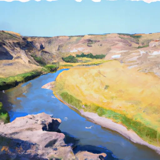
The class rating for this run is Class II-III, which means that it is suitable for intermediate paddlers with some experience. Some of the specific rapids and obstacles on this run include the "S-Turn Rapid," the "Mud Slide," and the "Potholes." These are all fun and challenging features that require paddlers to navigate carefully and strategically.
The total segment mileage for the Whitewater River Run is 11.5 miles, and it typically takes around 3-4 hours to complete. It is important to note that there are specific regulations in place for this area, including restrictions on camping and fires. Paddlers should also be aware of any wildlife in the area, such as bison, and give them a wide berth.
Overall, the Whitewater River Run is a great option for intermediate paddlers looking for a fun and challenging day on the water. With the right streamflow and careful navigation, paddlers can enjoy the beautiful scenery of Theodore Roosevelt National Park while navigating exciting rapids and obstacles.
Plan your run down to the hour
Same weather feed Snoflo's iOS app uses -- updated continuously from NOAA / yr.no. Watch the precipitation column on the meteogram; rain ahead of a run typically lifts flows 12-48 hours later depending on the basin.
Next 5 days, hour by hour
Temperature line with weather symbols on top, snow + rain accumulation as columns, humidity as a dotted line.
5-day forecast table
Every 3 hours, broken out across temperature, snow, rain, humidity, and wind. Each cell is colour-coded relative to the column min/max.
| Time | Condition | Temp (°F) | Snow (in) | Rain (in) | Humidity (%) | Wind (mps) | Wind dir |
|---|---|---|---|---|---|---|---|
| Loading detailed forecast… | |||||||
15-day temperature & precipitation
Daily temperatures, snow, and rain projected over the next two weeks -- the upstream story that drives next week's flows.
Regional streamflow levels
USGS streamgauges around Southern Boundary Of The Elkhorn Unit Of Theodore Roosevelt National Park To Northern Boundary Of The Elkhorn Unit Of Theodore Roosevelt National Park -- useful for spotting upstream pulses and gauging which tributary is contributing what.
| Streamgauge | Discharge | View |
|---|---|---|
| Beaver Creek Nr Trotters | 0 cfs | → |
| Little Missouri River At Medora | · | → |
| Little Missouri River Nr Watford City | 49 cfs | → |
| Green River Nr New Hradec | · | → |
| Yellowstone River Near Sidney Mt | 6,270 cfs | → |
| Knife River At Manning | 1 cfs | → |
Plan a longer trip
The closest boat launches, other paddle runs, and campgrounds so a day on the water can grow into a full weekend.
Other river runs
- Southern Boundary Of The South Unit Of Theodore Roosevelt National Park To Northern Boundary Of The South Unit Of Theodore Roosevelt National Park
- Northern Boundary Of Knife River Indian Villages National Historic Site To Southern Boundary Of Knife River Indian Villages National Historic Site
- Yellowstone River
Campgrounds
Whitewater safety
- Check the flow before you run
- Use the linked-gauge card and Regional Flow panel above. Class ratings change with flow -- a Class III at low water can become Class IV+ at high water.
- Know your skill ceiling
- Pick runs comfortably below your ceiling. Cold-water and big-water runs raise the consequences of any mistake.
- Wear the right gear
- Helmet, PFD, drysuit / wetsuit when water is below 60°F. Throw bag, knife, and whistle on your person, not in the boat.
- Scout, set safety, and run with a team
- Scout new rapids on foot, set safety with throw bags above the consequence pool, and run with at least one other competent paddler.
- Respect the river
- Strainers, undercuts, low-head dams, and wood can kill at any class rating. When in doubt, portage.
Set push alerts in the Snoflo app
Save Southern Boundary Of The Elkhorn Unit Of Theodore Roosevelt National Park To Northern Boundary Of The Elkhorn Unit Of Theodore Roosevelt National Park as a favorite, set a discharge threshold (e.g. "alert me when flow hits 600 cfs"), and the iOS app pushes the moment the linked gauge crosses.
About Southern Boundary Of The Elkhorn Unit Of Theodore Roosevelt National Park To Northern Boundary Of The Elkhorn Unit Of Theodore Roosevelt National Park
What's the optimal flow for Southern Boundary Of The Elkhorn Unit Of Theodore Roosevelt National Park To Northern Boundary Of The Elkhorn Unit Of Theodore Roosevelt National Park?
The optimal flow depends on the section and the craft. Check the Run Details panel for the linked gauge and current status.
How fresh is the cfs reading on this page?
The linked USGS streamgauge reports continuously (every 15 minutes); Snoflo refreshes throughout the day. Hover the streamflow sparkline to read individual datapoints.
What's the whitewater class?
See the Run Details panel for the class rating Snoflo tracks for this run. Class ratings change with flow -- a Class III at low water can become Class IV in high water.
Where do I put in / take out?
Tap Directions in the hero above to open driving directions to the put-in. For shuttle planning, check the Nearby Boat Launches panel and the river run operator's site.
Can I get alerts when flows hit the optimal range?
Yes -- alerts are managed in the Snoflo iOS app. Favorite this run, set a discharge threshold, and you'll get a push the moment the gauge crosses.
Other runs near here
Snoflo-tracked paddle runs within driving distance of Southern Boundary Of The Elkhorn Unit Of Theodore Roosevelt National Park To Northern Boundary Of The Elkhorn Unit Of Theodore Roosevelt National Park.