State Highway 4 To Broken Bow Lake River Run
Community Reviews
Been here? Share the conditions.
Reviews, ratings & photos are added in the free Snoflo iOS app — rate a spot, tag the conditions, and your visit is verified by location. Add or manage your reviews from the app.
State Highway 4 To Broken Bow Lake
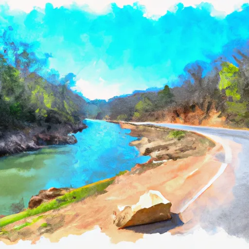
The river is rated as a Class II-III on the International Scale of River Difficulty, making it a great option for intermediate rafters. The run spans 8.5 miles from State Highway 4 to Broken Bow Lake and offers breathtaking views of the surrounding Ouachita Mountains.
There are several notable rapids and obstacles along the Whitewater River Run, including the Big Rock Drop and the Boquillas Canyon. The Big Rock Drop is a class III rapid that requires precise maneuvering to navigate successfully. Boquillas Canyon is a narrow passage with steep walls, providing a thrilling and scenic experience for rafters.
It is important to note that there are specific regulations to the area, including a limit on the number of rafts that can be on the river at any given time. Additionally, all rafters are required to wear personal flotation devices and follow Leave No Trace principles to protect the natural environment.
Overall, the Whitewater River Run is a must-visit destination for anyone looking to experience the thrill of whitewater rafting in Oklahoma.
Plan your run down to the hour
Same weather feed Snoflo's iOS app uses -- updated continuously from NOAA / yr.no. Watch the precipitation column on the meteogram; rain ahead of a run typically lifts flows 12-48 hours later depending on the basin.
Next 5 days, hour by hour
Temperature line with weather symbols on top, snow + rain accumulation as columns, humidity as a dotted line.
5-day forecast table
Every 3 hours, broken out across temperature, snow, rain, humidity, and wind. Each cell is colour-coded relative to the column min/max.
| Time | Condition | Temp (°F) | Snow (in) | Rain (in) | Humidity (%) | Wind (mps) | Wind dir |
|---|---|---|---|---|---|---|---|
| Loading detailed forecast… | |||||||
15-day temperature & precipitation
Daily temperatures, snow, and rain projected over the next two weeks -- the upstream story that drives next week's flows.
Regional streamflow levels
USGS streamgauges around State Highway 4 To Broken Bow Lake -- useful for spotting upstream pulses and gauging which tributary is contributing what.
| Streamgauge | Discharge | View |
|---|---|---|
| Mountain Fork At Smithville | 205 cfs | → |
| Kiamichi River Near Big Cedar | 0 cfs | → |
| Glover River Near Glover | 94 cfs | → |
| Mountain Fork Near Eagletown | 1,500 cfs | → |
| Cossatot River Near Vandervoort | 50 cfs | → |
| Little River Blw Lukfata Creek | 247 cfs | → |
Plan a longer trip
The closest boat launches, other paddle runs, and campgrounds so a day on the water can grow into a full weekend.
Boat launches
Other river runs
- Confluence Of East And West Forks, Sec 7, T3s, R23e To Nf Boundary Sec 32, T4s, R23e
- Headwaters In Sec 8, T1s, R31w To Nf Boundary At Acorn, Ar
- Sec 30, T3s, R27w To Sec 19, T4s, R24w
- Nf Boundary At Pine Ridge, Ar To Highway 298 Bridge Near Sims, Ar
- Highway 298 Bridge Near Sims, Ar To Slackwater Of Lake Ouachita
Campgrounds
Whitewater safety
- Check the flow before you run
- Use the linked-gauge card and Regional Flow panel above. Class ratings change with flow -- a Class III at low water can become Class IV+ at high water.
- Know your skill ceiling
- Pick runs comfortably below your ceiling. Cold-water and big-water runs raise the consequences of any mistake.
- Wear the right gear
- Helmet, PFD, drysuit / wetsuit when water is below 60°F. Throw bag, knife, and whistle on your person, not in the boat.
- Scout, set safety, and run with a team
- Scout new rapids on foot, set safety with throw bags above the consequence pool, and run with at least one other competent paddler.
- Respect the river
- Strainers, undercuts, low-head dams, and wood can kill at any class rating. When in doubt, portage.
Set push alerts in the Snoflo app
Save State Highway 4 To Broken Bow Lake as a favorite, set a discharge threshold (e.g. "alert me when flow hits 600 cfs"), and the iOS app pushes the moment the linked gauge crosses.
About State Highway 4 To Broken Bow Lake
What's the optimal flow for State Highway 4 To Broken Bow Lake?
The optimal flow depends on the section and the craft. Check the Run Details panel for the linked gauge and current status.
How fresh is the cfs reading on this page?
The linked USGS streamgauge reports continuously (every 15 minutes); Snoflo refreshes throughout the day. Hover the streamflow sparkline to read individual datapoints.
What's the whitewater class?
See the Run Details panel for the class rating Snoflo tracks for this run. Class ratings change with flow -- a Class III at low water can become Class IV in high water.
Where do I put in / take out?
Tap Directions in the hero above to open driving directions to the put-in. For shuttle planning, check the Nearby Boat Launches panel and the river run operator's site.
Can I get alerts when flows hit the optimal range?
Yes -- alerts are managed in the Snoflo iOS app. Favorite this run, set a discharge threshold, and you'll get a push the moment the gauge crosses.
Other runs near here
Snoflo-tracked paddle runs within driving distance of State Highway 4 To Broken Bow Lake.