Mt. Hood Wilderness Boundary To Confluence With Sandy River River Run
Community Reviews
Been here? Share the conditions.
Reviews, ratings & photos are added in the free Snoflo iOS app — rate a spot, tag the conditions, and your visit is verified by location. Add or manage your reviews from the app.
Mt. Hood Wilderness Boundary To Confluence With Sandy River
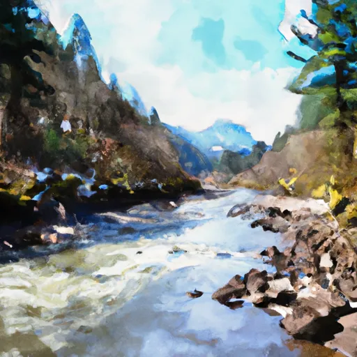
The Whitewater River run presents several rapids and obstacles, including "Boulder Sluice," "Pinball," and "Boxcar." These rapids offer challenging and thrilling experiences for rafters, but they require precise maneuvers and expert navigation skills. The run also features several scenic spots, such as the lush forests, imposing cliffs, and crystal-clear water that add to the beauty of the river.
There are specific regulations that rafters must follow to ensure their safety and preserve the natural environment. For instance, rafters must wear personal flotation devices (PFDs) at all times, and they must not litter or disturb the wildlife and vegetation in the area. Additionally, the Whitewater River run is only open during certain months of the year, usually between May and October, depending on the water level and weather conditions.
In conclusion, the Whitewater River run in Mt. Hood Wilderness Area is an exciting and challenging destination for white-water rafting enthusiasts. With its ideal streamflow range, Class III-IV rating, segment mileage, specific river rapids/obstacles, and regulations, this river run offers a perfect combination of adventure and natural beauty.
Plan your run down to the hour
Same weather feed Snoflo's iOS app uses -- updated continuously from NOAA / yr.no. Watch the precipitation column on the meteogram; rain ahead of a run typically lifts flows 12-48 hours later depending on the basin.
Next 5 days, hour by hour
Temperature line with weather symbols on top, snow + rain accumulation as columns, humidity as a dotted line.
5-day forecast table
Every 3 hours, broken out across temperature, snow, rain, humidity, and wind. Each cell is colour-coded relative to the column min/max.
| Time | Condition | Temp (°F) | Snow (in) | Rain (in) | Humidity (%) | Wind (mps) | Wind dir |
|---|---|---|---|---|---|---|---|
| Loading detailed forecast… | |||||||
15-day temperature & precipitation
Daily temperatures, snow, and rain projected over the next two weeks -- the upstream story that drives next week's flows.
Regional streamflow levels
USGS streamgauges around Mt. Hood Wilderness Boundary To Confluence With Sandy River -- useful for spotting upstream pulses and gauging which tributary is contributing what.
| Streamgauge | Discharge | View |
|---|---|---|
| Blazed Alder Creek Near Rhododendron | 2 cfs | → |
| Bull Run River At Lower Flume Nr Brightwood | 19 cfs | → |
| Sandy River Near Marmot | 277 cfs | → |
| Fir Creek Near Brightwood | 3 cfs | → |
| South Fork Bull Run River Near Bull Run | 10 cfs | → |
| Bull Run River Near Multnomah Falls | 44 cfs | → |
Plan a longer trip
The closest boat launches, other paddle runs, and campgrounds so a day on the water can grow into a full weekend.
Boat launches
- Trillium Lake Camp
- Lost Lake Resort
- Hole In The Wall Boat Access Day Site
- Clackamas Highway Clackamas County
- Laurance Lake
- Moore Creek Boat Access Day Site
Other river runs
- Sandy River
- Welches Run
- Salmon River Canyon (Split Falls To Road Access)
- North Fork Clackamas River
- Headwaters To North Section Line Of Sec 17, T4s, R5e
Campgrounds
Whitewater safety
- Check the flow before you run
- Use the linked-gauge card and Regional Flow panel above. Class ratings change with flow -- a Class III at low water can become Class IV+ at high water.
- Know your skill ceiling
- Pick runs comfortably below your ceiling. Cold-water and big-water runs raise the consequences of any mistake.
- Wear the right gear
- Helmet, PFD, drysuit / wetsuit when water is below 60°F. Throw bag, knife, and whistle on your person, not in the boat.
- Scout, set safety, and run with a team
- Scout new rapids on foot, set safety with throw bags above the consequence pool, and run with at least one other competent paddler.
- Respect the river
- Strainers, undercuts, low-head dams, and wood can kill at any class rating. When in doubt, portage.
Set push alerts in the Snoflo app
Save Mt. Hood Wilderness Boundary To Confluence With Sandy River as a favorite, set a discharge threshold (e.g. "alert me when flow hits 600 cfs"), and the iOS app pushes the moment the linked gauge crosses.
About Mt. Hood Wilderness Boundary To Confluence With Sandy River
What's the optimal flow for Mt. Hood Wilderness Boundary To Confluence With Sandy River?
The optimal flow depends on the section and the craft. Check the Run Details panel for the linked gauge and current status.
How fresh is the cfs reading on this page?
The linked USGS streamgauge reports continuously (every 15 minutes); Snoflo refreshes throughout the day. Hover the streamflow sparkline to read individual datapoints.
What's the whitewater class?
See the Run Details panel for the class rating Snoflo tracks for this run. Class ratings change with flow -- a Class III at low water can become Class IV in high water.
Where do I put in / take out?
Tap Directions in the hero above to open driving directions to the put-in. For shuttle planning, check the Nearby Boat Launches panel and the river run operator's site.
Can I get alerts when flows hit the optimal range?
Yes -- alerts are managed in the Snoflo iOS app. Favorite this run, set a discharge threshold, and you'll get a push the moment the gauge crosses.
Other runs near here
Snoflo-tracked paddle runs within driving distance of Mt. Hood Wilderness Boundary To Confluence With Sandy River.