Mt. Jefferson Wilderness Boundary To Confluence With Breitenbush River River Run
Community Reviews
Been here? Share the conditions.
Reviews, ratings & photos are added in the free Snoflo iOS app — rate a spot, tag the conditions, and your visit is verified by location. Add or manage your reviews from the app.
Mt. Jefferson Wilderness Boundary To Confluence With Breitenbush River
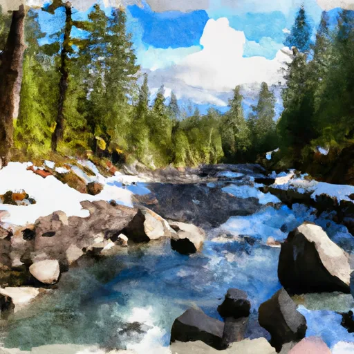
This run features several challenging rapids, including Big Brother, Little Brother, and the Nutcracker. The Big Brother rapid is a steep drop with a tight turn and requires precise maneuvering. Little Brother is a narrow, technical rapid with a strong eddy line. The Nutcracker is a complex series of drops and chutes that require careful planning and execution.
There are specific regulations that apply to this area, including permits for overnight camping and fire restrictions. It is important to check with the local ranger station for the most up-to-date information before planning a trip to this area.
Overall, the Whitewater River run is a challenging and rewarding destination for experienced kayakers and rafters. It is essential to have the proper equipment, skills, and knowledge of the area before attempting this run.
Plan your run down to the hour
Same weather feed Snoflo's iOS app uses -- updated continuously from NOAA / yr.no. Watch the precipitation column on the meteogram; rain ahead of a run typically lifts flows 12-48 hours later depending on the basin.
Next 5 days, hour by hour
Temperature line with weather symbols on top, snow + rain accumulation as columns, humidity as a dotted line.
5-day forecast table
Every 3 hours, broken out across temperature, snow, rain, humidity, and wind. Each cell is colour-coded relative to the column min/max.
| Time | Condition | Temp (°F) | Snow (in) | Rain (in) | Humidity (%) | Wind (mps) | Wind dir |
|---|---|---|---|---|---|---|---|
| Loading detailed forecast… | |||||||
15-day temperature & precipitation
Daily temperatures, snow, and rain projected over the next two weeks -- the upstream story that drives next week's flows.
Regional streamflow levels
USGS streamgauges around Mt. Jefferson Wilderness Boundary To Confluence With Breitenbush River -- useful for spotting upstream pulses and gauging which tributary is contributing what.
| Streamgauge | Discharge | View |
|---|---|---|
| No Santiam R Blw Boulder Crk | 430 cfs | → |
| Breitenbush R Abv French Cr Nr Detroit | 132 cfs | → |
| Blowout Creek Near Detroit | 8 cfs | → |
| Shitike Cr | 32 cfs | → |
| North Santiam River At Niagara | 1,020 cfs | → |
| Oak Grove Fork Above Powerplant Intake | 263 cfs | → |
Plan a longer trip
The closest boat launches, other paddle runs, and campgrounds so a day on the water can grow into a full weekend.
Boat launches
- Elk Lake Campgound
- Ollalie Lake Resort
- Hoover Campground
- Peninsula Campground
- Detroit Lake Marina
- Kane's Marina
Other river runs
- Russel Lake To Mt. Jefferson Wilderness Boundary
- Breitenbush Lake To Confluence With North Fork Breitenbush River
- Highway 22 To Confluence With Rainbow Creek
- Confluence With North Fork Breitenbush River To Detroit Reservoir
- Opal Lake To Confluence With Battle Axe Creek
Campgrounds
- Breitenbush Campground
- Cleator Bend Group Campground
- Fox Creek Group Campground
- Humbug Campground
- Whispering Falls Campground
- River Mountain Rv Park
Whitewater safety
- Check the flow before you run
- Use the linked-gauge card and Regional Flow panel above. Class ratings change with flow -- a Class III at low water can become Class IV+ at high water.
- Know your skill ceiling
- Pick runs comfortably below your ceiling. Cold-water and big-water runs raise the consequences of any mistake.
- Wear the right gear
- Helmet, PFD, drysuit / wetsuit when water is below 60°F. Throw bag, knife, and whistle on your person, not in the boat.
- Scout, set safety, and run with a team
- Scout new rapids on foot, set safety with throw bags above the consequence pool, and run with at least one other competent paddler.
- Respect the river
- Strainers, undercuts, low-head dams, and wood can kill at any class rating. When in doubt, portage.
Set push alerts in the Snoflo app
Save Mt. Jefferson Wilderness Boundary To Confluence With Breitenbush River as a favorite, set a discharge threshold (e.g. "alert me when flow hits 600 cfs"), and the iOS app pushes the moment the linked gauge crosses.
About Mt. Jefferson Wilderness Boundary To Confluence With Breitenbush River
What's the optimal flow for Mt. Jefferson Wilderness Boundary To Confluence With Breitenbush River?
The optimal flow depends on the section and the craft. Check the Run Details panel for the linked gauge and current status.
How fresh is the cfs reading on this page?
The linked USGS streamgauge reports continuously (every 15 minutes); Snoflo refreshes throughout the day. Hover the streamflow sparkline to read individual datapoints.
What's the whitewater class?
See the Run Details panel for the class rating Snoflo tracks for this run. Class ratings change with flow -- a Class III at low water can become Class IV in high water.
Where do I put in / take out?
Tap Directions in the hero above to open driving directions to the put-in. For shuttle planning, check the Nearby Boat Launches panel and the river run operator's site.
Can I get alerts when flows hit the optimal range?
Yes -- alerts are managed in the Snoflo iOS app. Favorite this run, set a discharge threshold, and you'll get a push the moment the gauge crosses.
Other runs near here
Snoflo-tracked paddle runs within driving distance of Mt. Jefferson Wilderness Boundary To Confluence With Breitenbush River.