Headwaters To Boulder Creek Wilderness Boundary river run
Community Reviews
Been here? Share the conditions.
Reviews, ratings & photos are added in the free Snoflo iOS app — rate a spot, tag the conditions, and your visit is verified by location. Add or manage your reviews from the app.
Headwaters To Boulder Creek Wilderness Boundary
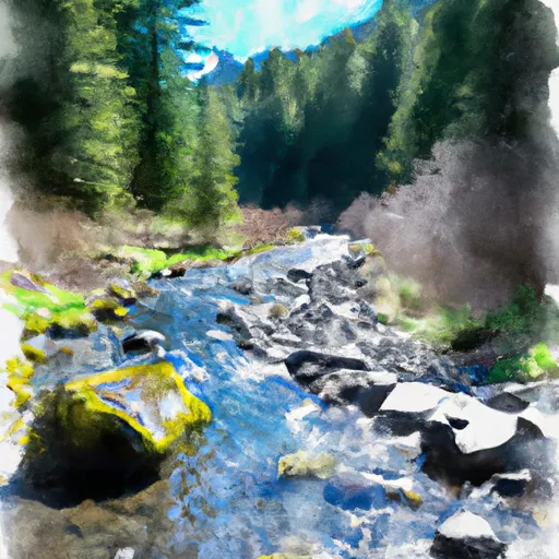
The Whitewater River run features several specific rapids and obstacles, including "The Toilet Bowl," "Mile 5," and "The Gauntlet." These rapids require expert skill and knowledge to navigate safely, making this run best suited for experienced paddlers. There are also several waterfalls along the run, including the impressive "Big Falls," which drops 35 feet into a large pool.
Specific regulations to the area include a permit requirement for overnight camping and a limit on group size to 12 people. Additionally, visitors are encouraged to practice Leave No Trace ethics and follow all fire restrictions and rules. It is important to note that in order to access the Headwaters To Boulder Creek Wilderness Boundary run, visitors must first obtain a parking permit from the National Forest Service.
Overall, the Whitewater River run Headwaters To Boulder Creek Wilderness Boundary in Oregon is a challenging and exciting adventure for experienced kayakers and rafters. With technical rapids, stunning waterfalls, and specific regulations to protect the area, it offers a unique and unforgettable river experience.
Plan your run down to the hour
Same weather feed Snoflo's iOS app uses -- updated continuously from NOAA / yr.no. Watch the precipitation column on the meteogram; rain ahead of a run typically lifts flows 12-48 hours later depending on the basin.
Next 5 days, hour by hour
Temperature line with weather symbols on top, snow + rain accumulation as columns, humidity as a dotted line.
5-day forecast table
Every 3 hours, broken out across temperature, snow, rain, humidity, and wind. Each cell is colour-coded relative to the column min/max.
| Time | Condition | Temp (°F) | Snow (in) | Rain (in) | Humidity (%) | Wind (mps) | Wind dir |
|---|---|---|---|---|---|---|---|
| Loading detailed forecast… | |||||||
15-day temperature & precipitation
Daily temperatures, snow, and rain projected over the next two weeks -- the upstream story that drives next week's flows.
Regional streamflow levels
USGS streamgauges around Headwaters To Boulder Creek Wilderness Boundary -- useful for spotting upstream pulses and gauging which tributary is contributing what.
| Streamgauge | Discharge | View |
|---|---|---|
| Boulder Creek Near Toketee Falls | 6 cfs | → |
| N Umpqua River Abv Copeland Ck Nr Toketee Falls | 699 cfs | → |
| N.Umpqua R Blw Soda Spgs Resv | 309 cfs | → |
| N.Umpqua R Blw Slide Ck Dam Nr Toketee Falls | 263 cfs | → |
| North Umpqua River At Toketee Falls Oreg. | 91 cfs | → |
| Fish Creek Abv Slipper Creek Nr Toketee Falls | 42 cfs | → |
Plan a longer trip
The closest boat launches, other paddle runs, and campgrounds so a day on the water can grow into a full weekend.
Boat launches
Other river runs
- Headwaters Of East Fork Steamboat Creek To Confluence With Siwash Creek
- Confluence Of Siwash Creek To Little Falls
- Little Falls To Confluence With North Umpqua River
- Lower Timpanogas Lake To Confluence With Echo Creek
- Headwaters To Rogue-Umpqua Wilderness Boundary
Whitewater safety
- Check the flow before you run
- Use the linked-gauge card and Regional Flow panel above. Class ratings change with flow -- a Class III at low water can become Class IV+ at high water.
- Know your skill ceiling
- Pick runs comfortably below your ceiling. Cold-water and big-water runs raise the consequences of any mistake.
- Wear the right gear
- Helmet, PFD, drysuit / wetsuit when water is below 60°F. Throw bag, knife, and whistle on your person, not in the boat.
- Scout, set safety, and run with a team
- Scout new rapids on foot, set safety with throw bags above the consequence pool, and run with at least one other competent paddler.
- Respect the river
- Strainers, undercuts, low-head dams, and wood can kill at any class rating. When in doubt, portage.
Set push alerts in the Snoflo app
Save Headwaters To Boulder Creek Wilderness Boundary as a favorite, set a discharge threshold (e.g. "alert me when flow hits 600 cfs"), and the iOS app pushes the moment the linked gauge crosses.
About Headwaters To Boulder Creek Wilderness Boundary
What's the optimal flow for Headwaters To Boulder Creek Wilderness Boundary?
The optimal flow depends on the section and the craft. Check the Run Details panel for the linked gauge and current status.
How fresh is the cfs reading on this page?
The linked USGS streamgauge reports continuously (every 15 minutes); Snoflo refreshes throughout the day. Hover the streamflow sparkline to read individual datapoints.
What's the whitewater class?
See the Run Details panel for the class rating Snoflo tracks for this run. Class ratings change with flow -- a Class III at low water can become Class IV in high water.
Where do I put in / take out?
Tap Directions in the hero above to open driving directions to the put-in. For shuttle planning, check the Nearby Boat Launches panel and the river run operator's site.
Can I get alerts when flows hit the optimal range?
Yes -- alerts are managed in the Snoflo iOS app. Favorite this run, set a discharge threshold, and you'll get a push the moment the gauge crosses.
Other runs near here
Snoflo-tracked paddle runs within driving distance of Headwaters To Boulder Creek Wilderness Boundary.