Little Falls To Confluence With North Umpqua River River Run
Community Reviews
Been here? Share the conditions.
Reviews, ratings & photos are added in the free Snoflo iOS app — rate a spot, tag the conditions, and your visit is verified by location. Add or manage your reviews from the app.
Little Falls To Confluence With North Umpqua River
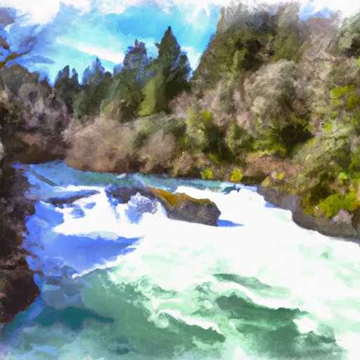
The class rating for this run is Class III-IV, with several notable rapids and obstacles including Little Falls, Horseshoe, and Pinball. These rapids require technical skill and experience to navigate safely.
The total segment mileage for this run is approximately 6.7 miles, with an average gradient of 55 feet per mile. The scenery on this run is beautiful, with rocky canyons and old-growth forests lining the riverbanks.
There are specific regulations to be aware of when planning a trip on this run. The North Umpqua River is designated as a Wild and Scenic River, which means that certain activities may be restricted or prohibited. Additionally, all boaters are required to carry a properly fitting personal flotation device and a whistle at all times.
Plan your run down to the hour
Same weather feed Snoflo's iOS app uses -- updated continuously from NOAA / yr.no. Watch the precipitation column on the meteogram; rain ahead of a run typically lifts flows 12-48 hours later depending on the basin.
Next 5 days, hour by hour
Temperature line with weather symbols on top, snow + rain accumulation as columns, humidity as a dotted line.
5-day forecast table
Every 3 hours, broken out across temperature, snow, rain, humidity, and wind. Each cell is colour-coded relative to the column min/max.
| Time | Condition | Temp (°F) | Snow (in) | Rain (in) | Humidity (%) | Wind (mps) | Wind dir |
|---|---|---|---|---|---|---|---|
| Loading detailed forecast… | |||||||
15-day temperature & precipitation
Daily temperatures, snow, and rain projected over the next two weeks -- the upstream story that drives next week's flows.
Regional streamflow levels
USGS streamgauges around Little Falls To Confluence With North Umpqua River -- useful for spotting upstream pulses and gauging which tributary is contributing what.
| Streamgauge | Discharge | View |
|---|---|---|
| Steamboat Creek Near Glide | 36 cfs | → |
| N Umpqua River Abv Copeland Ck Nr Toketee Falls | 693 cfs | → |
| Boulder Creek Near Toketee Falls | 5 cfs | → |
| N.Umpqua R Blw Soda Spgs Resv | 306 cfs | → |
| N.Umpqua R Blw Slide Ck Dam Nr Toketee Falls | 263 cfs | → |
| Little River At Peel | 2,120 cfs | → |
Plan a longer trip
The closest boat launches, other paddle runs, and campgrounds so a day on the water can grow into a full weekend.
Boat launches
- Gravel Bin Take Out
- Bogus Creek
- Bogus Raft Launch Boating Site
- Apple Creek Campground
- Horseshoe Bend
- Susan Creek
Other river runs
- Confluence Of Siwash Creek To Little Falls
- Headwaters Of East Fork Steamboat Creek To Confluence With Siwash Creek
- Headwaters To Boulder Creek Wilderness Boundary
- Lower Timpanogas Lake To Confluence With Echo Creek
- Confluence With Echo Creek To Hills Creek Reservoir
Whitewater safety
- Check the flow before you run
- Use the linked-gauge card and Regional Flow panel above. Class ratings change with flow -- a Class III at low water can become Class IV+ at high water.
- Know your skill ceiling
- Pick runs comfortably below your ceiling. Cold-water and big-water runs raise the consequences of any mistake.
- Wear the right gear
- Helmet, PFD, drysuit / wetsuit when water is below 60°F. Throw bag, knife, and whistle on your person, not in the boat.
- Scout, set safety, and run with a team
- Scout new rapids on foot, set safety with throw bags above the consequence pool, and run with at least one other competent paddler.
- Respect the river
- Strainers, undercuts, low-head dams, and wood can kill at any class rating. When in doubt, portage.
Set push alerts in the Snoflo app
Save Little Falls To Confluence With North Umpqua River as a favorite, set a discharge threshold (e.g. "alert me when flow hits 600 cfs"), and the iOS app pushes the moment the linked gauge crosses.
About Little Falls To Confluence With North Umpqua River
What's the optimal flow for Little Falls To Confluence With North Umpqua River?
The optimal flow depends on the section and the craft. Check the Run Details panel for the linked gauge and current status.
How fresh is the cfs reading on this page?
The linked USGS streamgauge reports continuously (every 15 minutes); Snoflo refreshes throughout the day. Hover the streamflow sparkline to read individual datapoints.
What's the whitewater class?
See the Run Details panel for the class rating Snoflo tracks for this run. Class ratings change with flow -- a Class III at low water can become Class IV in high water.
Where do I put in / take out?
Tap Directions in the hero above to open driving directions to the put-in. For shuttle planning, check the Nearby Boat Launches panel and the river run operator's site.
Can I get alerts when flows hit the optimal range?
Yes -- alerts are managed in the Snoflo iOS app. Favorite this run, set a discharge threshold, and you'll get a push the moment the gauge crosses.
Other runs near here
Snoflo-tracked paddle runs within driving distance of Little Falls To Confluence With North Umpqua River.