Mt. Jefferson Wilderness Boundary To Highway 22 River Run
Community Reviews
Been here? Share the conditions.
Reviews, ratings & photos are added in the free Snoflo iOS app — rate a spot, tag the conditions, and your visit is verified by location. Add or manage your reviews from the app.
Mt. Jefferson Wilderness Boundary To Highway 22
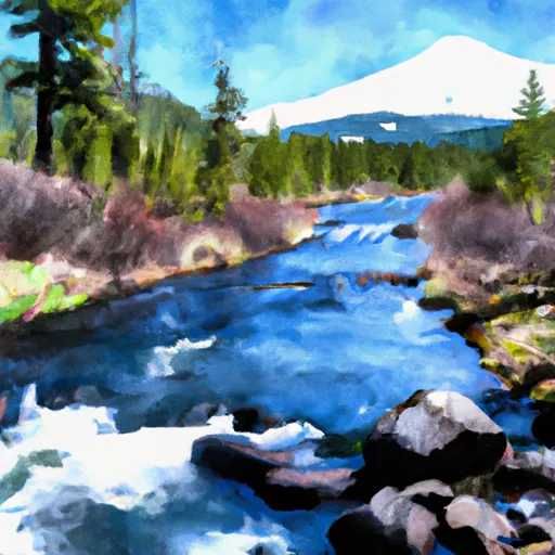
The segment mileage of the Whitewater River Run is approximately 12 miles, with numerous class III rapids and a few class IV rapids such as "The Chute" and "Bus Eater." Other obstacles to be aware of include logjams and sweepers, which can be dangerous if not navigated properly.
There are specific regulations to the area that visitors must abide by, including a permit requirement for overnight camping in the Mt. Jefferson Wilderness. Additionally, boaters must have a valid permit from the Bureau of Land Management to access the river. Visitors are also expected to follow Leave No Trace principles and respect the natural environment around them.
Overall, the Whitewater River Run is a challenging and exciting adventure for experienced paddlers. It's important to pay attention to the ideal streamflow range, class rating, segment mileage, specific river rapids/obstacles, and specific regulations to ensure a safe and enjoyable experience.
Plan your run down to the hour
Same weather feed Snoflo's iOS app uses -- updated continuously from NOAA / yr.no. Watch the precipitation column on the meteogram; rain ahead of a run typically lifts flows 12-48 hours later depending on the basin.
Next 5 days, hour by hour
Temperature line with weather symbols on top, snow + rain accumulation as columns, humidity as a dotted line.
5-day forecast table
Every 3 hours, broken out across temperature, snow, rain, humidity, and wind. Each cell is colour-coded relative to the column min/max.
| Time | Condition | Temp (°F) | Snow (in) | Rain (in) | Humidity (%) | Wind (mps) | Wind dir |
|---|---|---|---|---|---|---|---|
| Loading detailed forecast… | |||||||
15-day temperature & precipitation
Daily temperatures, snow, and rain projected over the next two weeks -- the upstream story that drives next week's flows.
Regional streamflow levels
USGS streamgauges around Mt. Jefferson Wilderness Boundary To Highway 22 -- useful for spotting upstream pulses and gauging which tributary is contributing what.
| Streamgauge | Discharge | View |
|---|---|---|
| Mckenzie River At Outlet Of Clear Lake | 165 cfs | → |
| Smith R Ab Smith R Res Nr Belknap Sprgs | 5 cfs | → |
| Blowout Creek Near Detroit | 7 cfs | → |
| Smith River Abv Trail Brdg Resv Nr Belknap Springs | 6 cfs | → |
| Mckenzie River Bl Payne Cr | 171 cfs | → |
| No Santiam R Blw Boulder Crk | 410 cfs | → |
Plan a longer trip
The closest boat launches, other paddle runs, and campgrounds so a day on the water can grow into a full weekend.
Boat launches
- Lost Lake Campground
- Clear Lake
- Cold Water Cove Campground
- Big Lake Campground
- Carmen Diversion Launch Ramp
- Lake's End Campground
Other river runs
- Headwaters To Mt Jefferson Wilderness Boundary
- West Section Line Of Sec 31, T12s, R6e To Middle Santiam Wilderness Boundary
- Headwaters To Confluence With Unnamed Creek West Of Bruler Creek
- Middle Santiam River
- Middle Santiam Wilderness Boundary To Willamette Nf Boundary
Campgrounds
- Big Meadows Horse Camp
- Camp Pioneer (Bsa Cascade Pacific Council)
- South Pyramid Horse Camp
- Fish Lake Remount Depot - Commissary Cabin
- Fish Lake Remount Depot - Hall House Cabin
- Lost Prairie Group Campground
Whitewater safety
- Check the flow before you run
- Use the linked-gauge card and Regional Flow panel above. Class ratings change with flow -- a Class III at low water can become Class IV+ at high water.
- Know your skill ceiling
- Pick runs comfortably below your ceiling. Cold-water and big-water runs raise the consequences of any mistake.
- Wear the right gear
- Helmet, PFD, drysuit / wetsuit when water is below 60°F. Throw bag, knife, and whistle on your person, not in the boat.
- Scout, set safety, and run with a team
- Scout new rapids on foot, set safety with throw bags above the consequence pool, and run with at least one other competent paddler.
- Respect the river
- Strainers, undercuts, low-head dams, and wood can kill at any class rating. When in doubt, portage.
Set push alerts in the Snoflo app
Save Mt. Jefferson Wilderness Boundary To Highway 22 as a favorite, set a discharge threshold (e.g. "alert me when flow hits 600 cfs"), and the iOS app pushes the moment the linked gauge crosses.
About Mt. Jefferson Wilderness Boundary To Highway 22
What's the optimal flow for Mt. Jefferson Wilderness Boundary To Highway 22?
The optimal flow depends on the section and the craft. Check the Run Details panel for the linked gauge and current status.
How fresh is the cfs reading on this page?
The linked USGS streamgauge reports continuously (every 15 minutes); Snoflo refreshes throughout the day. Hover the streamflow sparkline to read individual datapoints.
What's the whitewater class?
See the Run Details panel for the class rating Snoflo tracks for this run. Class ratings change with flow -- a Class III at low water can become Class IV in high water.
Where do I put in / take out?
Tap Directions in the hero above to open driving directions to the put-in. For shuttle planning, check the Nearby Boat Launches panel and the river run operator's site.
Can I get alerts when flows hit the optimal range?
Yes -- alerts are managed in the Snoflo iOS app. Favorite this run, set a discharge threshold, and you'll get a push the moment the gauge crosses.
Other runs near here
Snoflo-tracked paddle runs within driving distance of Mt. Jefferson Wilderness Boundary To Highway 22.