Crooked River National Grassland Boundary To Confluence With Deschutes River River Run
Community Reviews
Been here? Share the conditions.
Reviews, ratings & photos are added in the free Snoflo iOS app — rate a spot, tag the conditions, and your visit is verified by location. Add or manage your reviews from the app.
Crooked River National Grassland Boundary To Confluence With Deschutes River
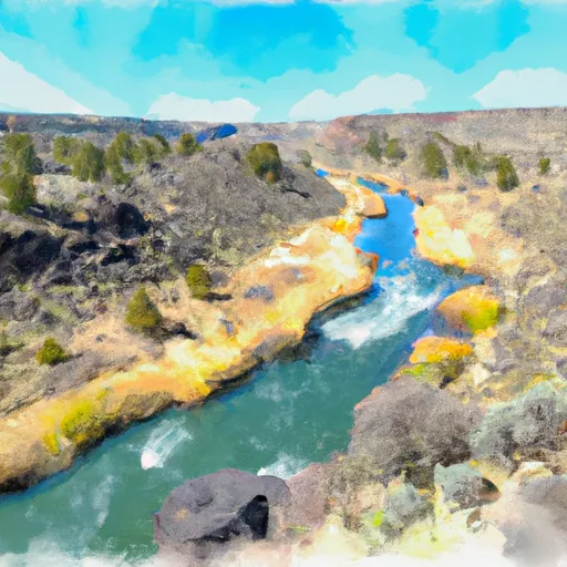
The segment mileage for this run is approximately 15 miles, starting at the Crooked River National Grassland boundary and ending at the confluence with the Deschutes River. The river features several notable rapids, including "Boxcar," "Tumwater," and "Train Wreck." These rapids are known for their technical challenges and require experienced paddlers to navigate safely.
There are specific regulations in place for this area to ensure the safety of all visitors. All paddlers are required to wear a personal flotation device (PFD) and a helmet. Additionally, motorized watercraft are not allowed on this section of the river. It is important to note that the river can be dangerous and unpredictable, and caution should be exercised at all times.
Overall, the Whitewater River Run from Crooked River National Grassland Boundary to Confluence with Deschutes River in Oregon offers a thrilling whitewater experience for experienced paddlers during the appropriate streamflow range. Visitors should be aware of the specific regulations and potential hazards before embarking on this adventure.
Plan your run down to the hour
Same weather feed Snoflo's iOS app uses -- updated continuously from NOAA / yr.no. Watch the precipitation column on the meteogram; rain ahead of a run typically lifts flows 12-48 hours later depending on the basin.
Next 5 days, hour by hour
Temperature line with weather symbols on top, snow + rain accumulation as columns, humidity as a dotted line.
5-day forecast table
Every 3 hours, broken out across temperature, snow, rain, humidity, and wind. Each cell is colour-coded relative to the column min/max.
| Time | Condition | Temp (°F) | Snow (in) | Rain (in) | Humidity (%) | Wind (mps) | Wind dir |
|---|---|---|---|---|---|---|---|
| Loading detailed forecast… | |||||||
15-day temperature & precipitation
Daily temperatures, snow, and rain projected over the next two weeks -- the upstream story that drives next week's flows.
Regional streamflow levels
USGS streamgauges around Crooked River National Grassland Boundary To Confluence With Deschutes River -- useful for spotting upstream pulses and gauging which tributary is contributing what.
| Streamgauge | Discharge | View |
|---|---|---|
| Deschutes River Near Culver | 518 cfs | → |
| Crooked River Below Opal Springs | 1,230 cfs | → |
| Crooked River Blw Osborne Canyon | 112 cfs | → |
| Metolius River Near Grandview | 1,230 cfs | → |
| Deschutes River Near Madras | 3,530 cfs | → |
| Shitike Creek Near Warm Springs | 36 cfs | → |
Plan a longer trip
The closest boat launches, other paddle runs, and campgrounds so a day on the water can grow into a full weekend.
Boat launches
- Cove Palisades - Upper Deschutes
- Cove Palisades - Lower Deschutes
- Crooked River
- Cove Palisades Marina
- Three Rivers Marina
- Haystack West
Other river runs
- Canyon Run (Lower Bridge To Billy Chinook Res.)
- Cline Falls State Park To Lower Bridge
- Source To Confluence With Metolius River
- Warm Springs To Sherars Falls
- Tumalo State Park To Cline Falls State Park
Campgrounds
- Steelhead Falls Campground
- Crooked River Ranch Rv Park
- Cove Palisades State Park
- Blm Beach Campground
- Haystack West Shore Campground And Day Use Area
- Haystack South Shore Group Campground
Whitewater safety
- Check the flow before you run
- Use the linked-gauge card and Regional Flow panel above. Class ratings change with flow -- a Class III at low water can become Class IV+ at high water.
- Know your skill ceiling
- Pick runs comfortably below your ceiling. Cold-water and big-water runs raise the consequences of any mistake.
- Wear the right gear
- Helmet, PFD, drysuit / wetsuit when water is below 60°F. Throw bag, knife, and whistle on your person, not in the boat.
- Scout, set safety, and run with a team
- Scout new rapids on foot, set safety with throw bags above the consequence pool, and run with at least one other competent paddler.
- Respect the river
- Strainers, undercuts, low-head dams, and wood can kill at any class rating. When in doubt, portage.
Set push alerts in the Snoflo app
Save Crooked River National Grassland Boundary To Confluence With Deschutes River as a favorite, set a discharge threshold (e.g. "alert me when flow hits 600 cfs"), and the iOS app pushes the moment the linked gauge crosses.
About Crooked River National Grassland Boundary To Confluence With Deschutes River
What's the optimal flow for Crooked River National Grassland Boundary To Confluence With Deschutes River?
The optimal flow depends on the section and the craft. Check the Run Details panel for the linked gauge and current status.
How fresh is the cfs reading on this page?
The linked USGS streamgauge reports continuously (every 15 minutes); Snoflo refreshes throughout the day. Hover the streamflow sparkline to read individual datapoints.
What's the whitewater class?
See the Run Details panel for the class rating Snoflo tracks for this run. Class ratings change with flow -- a Class III at low water can become Class IV in high water.
Where do I put in / take out?
Tap Directions in the hero above to open driving directions to the put-in. For shuttle planning, check the Nearby Boat Launches panel and the river run operator's site.
Can I get alerts when flows hit the optimal range?
Yes -- alerts are managed in the Snoflo iOS app. Favorite this run, set a discharge threshold, and you'll get a push the moment the gauge crosses.
Other runs near here
Snoflo-tracked paddle runs within driving distance of Crooked River National Grassland Boundary To Confluence With Deschutes River.