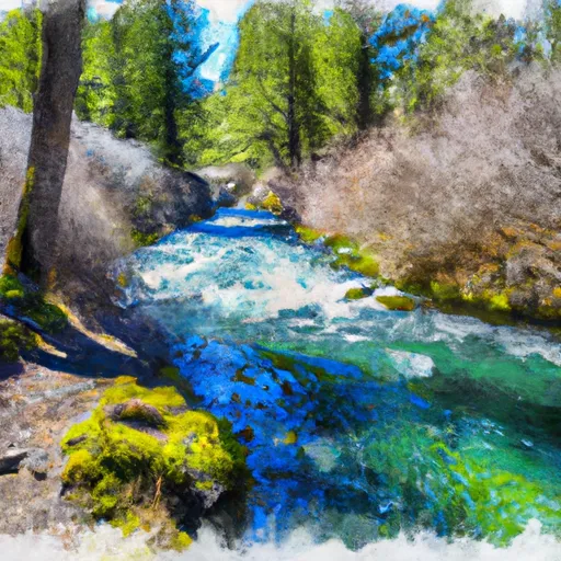
Headwaters Of Sevenmile Creek To Confluence With Latiwi Creek River Run
Community Reviews
Been here? Share the conditions.
Reviews, ratings & photos are added in the free Snoflo iOS app — rate a spot, tag the conditions, and your visit is verified by location. Add or manage your reviews from the app.
Headwaters Of Sevenmile Creek To Confluence With Latiwi Creek
The segment from the Headwaters of Sevenmile Creek to the confluence with Latiwi Creek is approximately 8.5 miles long and is rated as a class III-IV run. There are several notable rapids and obstacles along the way, including the S-Turn, which is a challenging rapid with a steep drop and powerful waves.
It is important to note that there are specific regulations in place for this area. The Oregon State Marine Board requires all boaters to have a valid boating permit and to wear a personal flotation device at all times while on the river. Additionally, camping and fires are prohibited along the riverbanks to protect the sensitive riparian habitat.
Plan your run down to the hour
Same weather feed Snoflo's iOS app uses -- updated continuously from NOAA / yr.no. Watch the precipitation column on the meteogram; rain ahead of a run typically lifts flows 12-48 hours later depending on the basin.
Next 5 days, hour by hour
Temperature line with weather symbols on top, snow + rain accumulation as columns, humidity as a dotted line.
5-day forecast table
Every 3 hours, broken out across temperature, snow, rain, humidity, and wind. Each cell is colour-coded relative to the column min/max.
| Time | Condition | Temp (°F) | Snow (in) | Rain (in) | Humidity (%) | Wind (mps) | Wind dir |
|---|---|---|---|---|---|---|---|
| Loading detailed forecast… | |||||||
15-day temperature & precipitation
Daily temperatures, snow, and rain projected over the next two weeks -- the upstream story that drives next week's flows.
Regional streamflow levels
USGS streamgauges around Headwaters Of Sevenmile Creek To Confluence With Latiwi Creek -- useful for spotting upstream pulses and gauging which tributary is contributing what.
| Streamgauge | Discharge | View |
|---|---|---|
| Smith R Ab Smith R Res Nr Belknap Sprgs | 4 cfs | → |
| Smith River Abv Trail Brdg Resv Nr Belknap Springs | 5 cfs | → |
| Mckenzie River Bl Payne Cr | 167 cfs | → |
| Mckenzie R Blw Trail Br Dam Nr Belknap Springs | 601 cfs | → |
| Mckenzie River At Outlet Of Clear Lake | 157 cfs | → |
| Lookout Creek Near Blue River | 14 cfs | → |
Plan a longer trip
The closest boat launches, other paddle runs, and campgrounds so a day on the water can grow into a full weekend.
Boat launches
Other river runs
- Headwaters To Blue River Reservoir
- West Section Line Of Sec 31, T12s, R6e To Middle Santiam Wilderness Boundary
- Middle Santiam River
- Middle Santiam Wilderness Boundary To Willamette Nf Boundary
- Sevenmile Creek To Willamette Nf Boundary
Campgrounds
Whitewater safety
- Check the flow before you run
- Use the linked-gauge card and Regional Flow panel above. Class ratings change with flow -- a Class III at low water can become Class IV+ at high water.
- Know your skill ceiling
- Pick runs comfortably below your ceiling. Cold-water and big-water runs raise the consequences of any mistake.
- Wear the right gear
- Helmet, PFD, drysuit / wetsuit when water is below 60°F. Throw bag, knife, and whistle on your person, not in the boat.
- Scout, set safety, and run with a team
- Scout new rapids on foot, set safety with throw bags above the consequence pool, and run with at least one other competent paddler.
- Respect the river
- Strainers, undercuts, low-head dams, and wood can kill at any class rating. When in doubt, portage.
Set push alerts in the Snoflo app
Save Headwaters Of Sevenmile Creek To Confluence With Latiwi Creek as a favorite, set a discharge threshold (e.g. "alert me when flow hits 600 cfs"), and the iOS app pushes the moment the linked gauge crosses.
About Headwaters Of Sevenmile Creek To Confluence With Latiwi Creek
What's the optimal flow for Headwaters Of Sevenmile Creek To Confluence With Latiwi Creek?
The optimal flow depends on the section and the craft. Check the Run Details panel for the linked gauge and current status.
How fresh is the cfs reading on this page?
The linked USGS streamgauge reports continuously (every 15 minutes); Snoflo refreshes throughout the day. Hover the streamflow sparkline to read individual datapoints.
What's the whitewater class?
See the Run Details panel for the class rating Snoflo tracks for this run. Class ratings change with flow -- a Class III at low water can become Class IV in high water.
Where do I put in / take out?
Tap Directions in the hero above to open driving directions to the put-in. For shuttle planning, check the Nearby Boat Launches panel and the river run operator's site.
Can I get alerts when flows hit the optimal range?
Yes -- alerts are managed in the Snoflo iOS app. Favorite this run, set a discharge threshold, and you'll get a push the moment the gauge crosses.
Other runs near here
Snoflo-tracked paddle runs within driving distance of Headwaters Of Sevenmile Creek To Confluence With Latiwi Creek.