Rm 47 To Rm 52 (Upper End Of Nestucca River) River Run
Community Reviews
Been here? Share the conditions.
Reviews, ratings & photos are added in the free Snoflo iOS app — rate a spot, tag the conditions, and your visit is verified by location. Add or manage your reviews from the app.
Rm 47 To Rm 52 (Upper End Of Nestucca River)
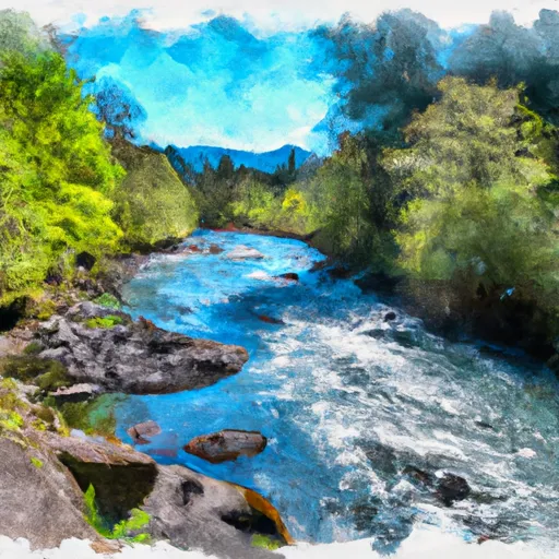
Some of the specific rapids and obstacles on this stretch of river include the Narrows, a narrow and steep drop, the Grotto, a boulder garden rapid, and the S-Turns, a series of tight turns with strong currents. Rafters and kayakers should also be aware of the rocks and logs in the river, which can be hazardous.
The specific regulations for this area include a permit requirement for all commercial outfitters and a limit on the number of commercial trips per day. Additionally, recreational boaters are required to wear a Type III or V personal flotation device while on the river.
Overall, the Whitewater River run from Rm 47 to Rm 52 on the Upper End of Nestucca River is an exciting and challenging stretch of river for experienced kayakers and rafters. Boaters should be aware of the ideal streamflow range, class rating, specific rapids and obstacles, and regulations for the area before embarking on their adventure.
Plan your run down to the hour
Same weather feed Snoflo's iOS app uses -- updated continuously from NOAA / yr.no. Watch the precipitation column on the meteogram; rain ahead of a run typically lifts flows 12-48 hours later depending on the basin.
Next 5 days, hour by hour
Temperature line with weather symbols on top, snow + rain accumulation as columns, humidity as a dotted line.
5-day forecast table
Every 3 hours, broken out across temperature, snow, rain, humidity, and wind. Each cell is colour-coded relative to the column min/max.
| Time | Condition | Temp (°F) | Snow (in) | Rain (in) | Humidity (%) | Wind (mps) | Wind dir |
|---|---|---|---|---|---|---|---|
| Loading detailed forecast… | |||||||
15-day temperature & precipitation
Daily temperatures, snow, and rain projected over the next two weeks -- the upstream story that drives next week's flows.
Regional streamflow levels
USGS streamgauges around Rm 47 To Rm 52 (Upper End Of Nestucca River) -- useful for spotting upstream pulses and gauging which tributary is contributing what.
| Streamgauge | Discharge | View |
|---|---|---|
| Tucca Creek Near Blaine | 2 cfs | → |
| South Yamhill River At Mcminnville | 48 cfs | → |
| Tualatin River Near Dilley | 199 cfs | → |
| Trask River Above Cedar Creek | 122 cfs | → |
| Willamette River At Newberg | 6,050 cfs | → |
| Wilson River Near Tillamook | 115 cfs | → |
Plan a longer trip
The closest boat launches, other paddle runs, and campgrounds so a day on the water can grow into a full weekend.
Boat launches
Other river runs
- County Boudary (Confluence With Wsr) To Rm 47 (Lower End Mcguire Reservoir)
- Nestucca River Seg B
- Tualatin River
- North Fork Trask River
- South Fork Trask River
Campgrounds
- Fan Creek Campground
- Dovre Campground
- Camp Cooper (Bsa Cascade Pacific Council)
- Elk Bend Campground
- Alder Glen Campground
- Rocky Bend
Whitewater safety
- Check the flow before you run
- Use the linked-gauge card and Regional Flow panel above. Class ratings change with flow -- a Class III at low water can become Class IV+ at high water.
- Know your skill ceiling
- Pick runs comfortably below your ceiling. Cold-water and big-water runs raise the consequences of any mistake.
- Wear the right gear
- Helmet, PFD, drysuit / wetsuit when water is below 60°F. Throw bag, knife, and whistle on your person, not in the boat.
- Scout, set safety, and run with a team
- Scout new rapids on foot, set safety with throw bags above the consequence pool, and run with at least one other competent paddler.
- Respect the river
- Strainers, undercuts, low-head dams, and wood can kill at any class rating. When in doubt, portage.
Set push alerts in the Snoflo app
Save Rm 47 To Rm 52 (Upper End Of Nestucca River) as a favorite, set a discharge threshold (e.g. "alert me when flow hits 600 cfs"), and the iOS app pushes the moment the linked gauge crosses.
About Rm 47 To Rm 52 (Upper End Of Nestucca River)
What's the optimal flow for Rm 47 To Rm 52 (Upper End Of Nestucca River)?
The optimal flow depends on the section and the craft. Check the Run Details panel for the linked gauge and current status.
How fresh is the cfs reading on this page?
The linked USGS streamgauge reports continuously (every 15 minutes); Snoflo refreshes throughout the day. Hover the streamflow sparkline to read individual datapoints.
What's the whitewater class?
See the Run Details panel for the class rating Snoflo tracks for this run. Class ratings change with flow -- a Class III at low water can become Class IV in high water.
Where do I put in / take out?
Tap Directions in the hero above to open driving directions to the put-in. For shuttle planning, check the Nearby Boat Launches panel and the river run operator's site.
Can I get alerts when flows hit the optimal range?
Yes -- alerts are managed in the Snoflo iOS app. Favorite this run, set a discharge threshold, and you'll get a push the moment the gauge crosses.
Other runs near here
Snoflo-tracked paddle runs within driving distance of Rm 47 To Rm 52 (Upper End Of Nestucca River).