Big Butte Creek (Incl South Fork Big Butte Creek) River Run
Community Reviews
Been here? Share the conditions.
Reviews, ratings & photos are added in the free Snoflo iOS app — rate a spot, tag the conditions, and your visit is verified by location. Add or manage your reviews from the app.
Big Butte Creek (Incl South Fork Big Butte Creek)
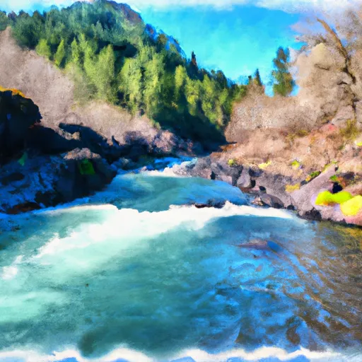
The Big Butte creek features several challenging rapids such as the popular "Boxcar" rapid, which features a steep drop and turbulent water. Other notable rapids include "Fowler's" and "Cave Man."
There are specific regulations in place for the Big Butte Creek, including the requirement of a permit from the Bureau of Land Management, which can be obtained online. Additionally, there are restrictions on camping and fires in the area to protect the natural environment.
According to American Whitewater, the Big Butte Creek is a "hidden gem" that offers a scenic and thrilling river run for experienced whitewater enthusiasts. With its challenging rapids and stunning natural beauty, the Big Butte Creek is definitely worth a visit for those looking for an adrenaline rush on the water.
Plan your run down to the hour
Same weather feed Snoflo's iOS app uses -- updated continuously from NOAA / yr.no. Watch the precipitation column on the meteogram; rain ahead of a run typically lifts flows 12-48 hours later depending on the basin.
Next 5 days, hour by hour
Temperature line with weather symbols on top, snow + rain accumulation as columns, humidity as a dotted line.
5-day forecast table
Every 3 hours, broken out across temperature, snow, rain, humidity, and wind. Each cell is colour-coded relative to the column min/max.
| Time | Condition | Temp (°F) | Snow (in) | Rain (in) | Humidity (%) | Wind (mps) | Wind dir |
|---|---|---|---|---|---|---|---|
| Loading detailed forecast… | |||||||
15-day temperature & precipitation
Daily temperatures, snow, and rain projected over the next two weeks -- the upstream story that drives next week's flows.
Regional streamflow levels
USGS streamgauges around Big Butte Creek (Incl South Fork Big Butte Creek) -- useful for spotting upstream pulses and gauging which tributary is contributing what.
| Streamgauge | Discharge | View |
|---|---|---|
| South Fork Rogue River Near Prospect | 38 cfs | → |
| Rogue River Below Prospect | 617 cfs | → |
| Big Butte Creek Near Mcleod | 25 cfs | → |
| Rogue R At Cole M Rivers F Hatchery Nr Mcleod | 1,070 cfs | → |
| Rogue River Near Mcleod | 1,440 cfs | → |
| Rogue River Above Prospect | 811 cfs | → |
Plan a longer trip
The closest boat launches, other paddle runs, and campgrounds so a day on the water can grow into a full weekend.
Boat launches
- Willow Lake County Park
- Fourmile Lake Campground
- Fish Lake Boating Site
- Fish Lake Resort
- Joseph Stewart State Park
- Takelma Park
Other river runs
- Sw1/4 Of Sec 1, T33s, R4e To Rogue River Nf Boundary
- Headwaters To Sw1/4 Of Sec 1, T33s, R4e
- Rogue River
- Lost Creek Lake To Gold Ray Dam
- South Fork Little Butte Creek
Campgrounds
- Whiskey Springs
- Fourbit Ford Campground
- Fourbit Ford
- Whiskey Springs Campground
- Group Camp
- Parker Meadows Campground
Whitewater safety
- Check the flow before you run
- Use the linked-gauge card and Regional Flow panel above. Class ratings change with flow -- a Class III at low water can become Class IV+ at high water.
- Know your skill ceiling
- Pick runs comfortably below your ceiling. Cold-water and big-water runs raise the consequences of any mistake.
- Wear the right gear
- Helmet, PFD, drysuit / wetsuit when water is below 60°F. Throw bag, knife, and whistle on your person, not in the boat.
- Scout, set safety, and run with a team
- Scout new rapids on foot, set safety with throw bags above the consequence pool, and run with at least one other competent paddler.
- Respect the river
- Strainers, undercuts, low-head dams, and wood can kill at any class rating. When in doubt, portage.
Set push alerts in the Snoflo app
Save Big Butte Creek (Incl South Fork Big Butte Creek) as a favorite, set a discharge threshold (e.g. "alert me when flow hits 600 cfs"), and the iOS app pushes the moment the linked gauge crosses.
About Big Butte Creek (Incl South Fork Big Butte Creek)
What's the optimal flow for Big Butte Creek (Incl South Fork Big Butte Creek)?
The optimal flow depends on the section and the craft. Check the Run Details panel for the linked gauge and current status.
How fresh is the cfs reading on this page?
The linked USGS streamgauge reports continuously (every 15 minutes); Snoflo refreshes throughout the day. Hover the streamflow sparkline to read individual datapoints.
What's the whitewater class?
See the Run Details panel for the class rating Snoflo tracks for this run. Class ratings change with flow -- a Class III at low water can become Class IV in high water.
Where do I put in / take out?
Tap Directions in the hero above to open driving directions to the put-in. For shuttle planning, check the Nearby Boat Launches panel and the river run operator's site.
Can I get alerts when flows hit the optimal range?
Yes -- alerts are managed in the Snoflo iOS app. Favorite this run, set a discharge threshold, and you'll get a push the moment the gauge crosses.
Other runs near here
Snoflo-tracked paddle runs within driving distance of Big Butte Creek (Incl South Fork Big Butte Creek).