North Fork Gate Creek River Run
Community Reviews
Been here? Share the conditions.
Reviews, ratings & photos are added in the free Snoflo iOS app — rate a spot, tag the conditions, and your visit is verified by location. Add or manage your reviews from the app.
North Fork Gate Creek
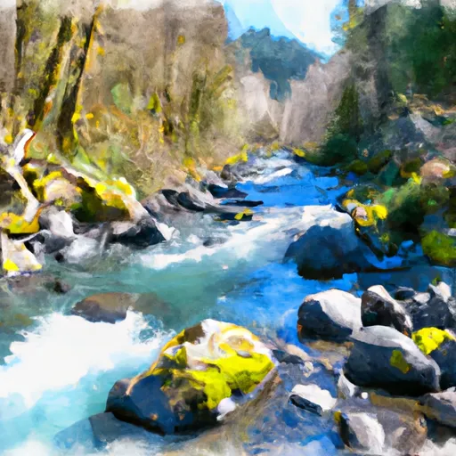
The North Fork Gate Creek, located in southwestern Oregon, is a popular whitewater river run among kayakers and rafters. The ideal streamflow range for this river is between 600 and 2000 cfs, with the best times for rafting being in late spring and early summer.
The North Fork Gate Creek is a class III-IV river, meaning it has moderate to difficult rapids with high waves and narrow passages. The segment mileage is approximately 5.5 miles, and the run takes around 2-3 hours to complete.
There are specific river rapids and obstacles on the North Fork Gate Creek that are notable. One of the most well-known rapids is called "Pegasus," which is a class IV rapid with a steep drop and a tight chute. Another notable rapid is "Guardian," a class III rapid with a large rock in the center that requires precise navigation.
There are specific regulations to the area that kayakers and rafters must be aware of. The North Fork Gate Creek is located in the Rogue River-Siskiyou National Forest and is subject to regulations set forth by the Forest Service. A permit is required for commercial rafting operations, and all river users must adhere to Leave No Trace principles.
Plan your run down to the hour
Same weather feed Snoflo's iOS app uses -- updated continuously from NOAA / yr.no. Watch the precipitation column on the meteogram; rain ahead of a run typically lifts flows 12-48 hours later depending on the basin.
Next 5 days, hour by hour
Temperature line with weather symbols on top, snow + rain accumulation as columns, humidity as a dotted line.
5-day forecast table
Every 3 hours, broken out across temperature, snow, rain, humidity, and wind. Each cell is colour-coded relative to the column min/max.
| Time | Condition | Temp (°F) | Snow (in) | Rain (in) | Humidity (%) | Wind (mps) | Wind dir |
|---|---|---|---|---|---|---|---|
| Loading detailed forecast… | |||||||
15-day temperature & precipitation
Daily temperatures, snow, and rain projected over the next two weeks -- the upstream story that drives next week's flows.
Regional streamflow levels
USGS streamgauges around North Fork Gate Creek -- useful for spotting upstream pulses and gauging which tributary is contributing what.
| Streamgauge | Discharge | View |
|---|---|---|
| Mckenzie River Near Vida | 1,860 cfs | → |
| Mckenzie River Blw Leaburg Dam | 1,830 cfs | → |
| Blue River At Blue River | 221 cfs | → |
| Mckenzie River Near Walterville | 1,760 cfs | → |
| South Fork Mckenzie River Near Rainbow | 336 cfs | → |
| Lookout Creek Near Blue River | 14 cfs | → |
Plan a longer trip
The closest boat launches, other paddle runs, and campgrounds so a day on the water can grow into a full weekend.
Boat launches
- Helfrich Landing
- Ben &Amp; Kay Dorris Park
- Ikes Landing
- Leaburg Dam
- Lloyd Knoxwater Board Park
- Rennie Landing
Other river runs
- South Fork Gate Creek
- Mckenzie River Seg B
- Mckenzie River Seg A
- Below Cougar Dam To Confluence With Mckenzie River
- Fall Creek - Eugene
Campgrounds
Whitewater safety
- Check the flow before you run
- Use the linked-gauge card and Regional Flow panel above. Class ratings change with flow -- a Class III at low water can become Class IV+ at high water.
- Know your skill ceiling
- Pick runs comfortably below your ceiling. Cold-water and big-water runs raise the consequences of any mistake.
- Wear the right gear
- Helmet, PFD, drysuit / wetsuit when water is below 60°F. Throw bag, knife, and whistle on your person, not in the boat.
- Scout, set safety, and run with a team
- Scout new rapids on foot, set safety with throw bags above the consequence pool, and run with at least one other competent paddler.
- Respect the river
- Strainers, undercuts, low-head dams, and wood can kill at any class rating. When in doubt, portage.
Set push alerts in the Snoflo app
Save North Fork Gate Creek as a favorite, set a discharge threshold (e.g. "alert me when flow hits 600 cfs"), and the iOS app pushes the moment the linked gauge crosses.
About North Fork Gate Creek
What's the optimal flow for North Fork Gate Creek?
The optimal flow depends on the section and the craft. Check the Run Details panel for the linked gauge and current status.
How fresh is the cfs reading on this page?
The linked USGS streamgauge reports continuously (every 15 minutes); Snoflo refreshes throughout the day. Hover the streamflow sparkline to read individual datapoints.
What's the whitewater class?
See the Run Details panel for the class rating Snoflo tracks for this run. Class ratings change with flow -- a Class III at low water can become Class IV in high water.
Where do I put in / take out?
Tap Directions in the hero above to open driving directions to the put-in. For shuttle planning, check the Nearby Boat Launches panel and the river run operator's site.
Can I get alerts when flows hit the optimal range?
Yes -- alerts are managed in the Snoflo iOS app. Favorite this run, set a discharge threshold, and you'll get a push the moment the gauge crosses.
Other runs near here
Snoflo-tracked paddle runs within driving distance of North Fork Gate Creek.