South Yamhill River River Run
Community Reviews
Been here? Share the conditions.
Reviews, ratings & photos are added in the free Snoflo iOS app — rate a spot, tag the conditions, and your visit is verified by location. Add or manage your reviews from the app.
South Yamhill River
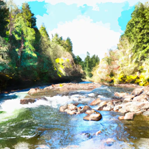
The South Yamhill River is a popular destination for whitewater enthusiasts in Oregon. It is rated as a Class III/IV river, meaning that it contains rapids that are challenging and require good technique and experience to navigate safely. The ideal streamflow range for the South Yamhill River is between 400 and 1000 cfs, although experienced paddlers may choose to run it at higher or lower levels.
The river runs for approximately 15 miles, starting near the town of McMinnville and flowing south through scenic forested areas and farmland. The rapids on the South Yamhill River offer a mix of technical moves and powerful waves, with notable obstacles including the "Cement Bridge" rapid, "S-Turn," and "Roller Coaster."
There are several regulations and restrictions that apply to the South Yamhill River. The river is managed by the Oregon Department of Fish and Wildlife, which requires all paddlers to have a valid fishing license. Additionally, there are several access points and put-in locations that require permits or fees, including the Oregon Department of Fish and Wildlife access site at the Haskins Bridge and the McMinnville Parks and Recreation Department access point at Lafayette Park.
Overall, the South Yamhill River is a challenging and rewarding destination for experienced whitewater paddlers in Oregon. It offers a mix of technical maneuvers, power waves, and scenic surroundings, making it a popular choice for those seeking adventure on the water.
Plan your run down to the hour
Same weather feed Snoflo's iOS app uses -- updated continuously from NOAA / yr.no. Watch the precipitation column on the meteogram; rain ahead of a run typically lifts flows 12-48 hours later depending on the basin.
Next 5 days, hour by hour
Temperature line with weather symbols on top, snow + rain accumulation as columns, humidity as a dotted line.
5-day forecast table
Every 3 hours, broken out across temperature, snow, rain, humidity, and wind. Each cell is colour-coded relative to the column min/max.
| Time | Condition | Temp (°F) | Snow (in) | Rain (in) | Humidity (%) | Wind (mps) | Wind dir |
|---|---|---|---|---|---|---|---|
| Loading detailed forecast… | |||||||
15-day temperature & precipitation
Daily temperatures, snow, and rain projected over the next two weeks -- the upstream story that drives next week's flows.
Regional streamflow levels
USGS streamgauges around South Yamhill River -- useful for spotting upstream pulses and gauging which tributary is contributing what.
| Streamgauge | Discharge | View |
|---|---|---|
| Nestucca River Near Beaver | 101 cfs | → |
| Tucca Creek Near Blaine | 1 cfs | → |
| Trask River Above Cedar Creek | 105 cfs | → |
| Wilson River Near Tillamook | 98 cfs | → |
| South Yamhill River At Mcminnville | 24 cfs | → |
| Siletz River At Siletz | 86 cfs | → |
Plan a longer trip
The closest boat launches, other paddle runs, and campgrounds so a day on the water can grow into a full weekend.
Boat launches
- Oregon Coast Highway Cloverdale
- Meda Loop Road Tillamook County
- Three Rivers
- Farmer Creek
- Fourth Bridge
- First Bridge Ramp
Other river runs
- Nestucca River Seg B
- Rm 26 To Rm 32 Confluence With Wsr
- North Fork Siletz River
- Rm 7 To Rm 15 (Town Of Beaver)
- Rm 15 To Rm 26 (Above Confluence Of Limestone Creek)
Campgrounds
- South Lake Dispersed Area
- South Lake
- South Lake Dispersed Camping
- Castle Rock Campground
- Castle Rock Group Campground
- Hebo Lake Campground
Whitewater safety
- Check the flow before you run
- Use the linked-gauge card and Regional Flow panel above. Class ratings change with flow -- a Class III at low water can become Class IV+ at high water.
- Know your skill ceiling
- Pick runs comfortably below your ceiling. Cold-water and big-water runs raise the consequences of any mistake.
- Wear the right gear
- Helmet, PFD, drysuit / wetsuit when water is below 60°F. Throw bag, knife, and whistle on your person, not in the boat.
- Scout, set safety, and run with a team
- Scout new rapids on foot, set safety with throw bags above the consequence pool, and run with at least one other competent paddler.
- Respect the river
- Strainers, undercuts, low-head dams, and wood can kill at any class rating. When in doubt, portage.
Set push alerts in the Snoflo app
Save South Yamhill River as a favorite, set a discharge threshold (e.g. "alert me when flow hits 600 cfs"), and the iOS app pushes the moment the linked gauge crosses.
About South Yamhill River
What's the optimal flow for South Yamhill River?
The optimal flow depends on the section and the craft. Check the Run Details panel for the linked gauge and current status.
How fresh is the cfs reading on this page?
The linked USGS streamgauge reports continuously (every 15 minutes); Snoflo refreshes throughout the day. Hover the streamflow sparkline to read individual datapoints.
What's the whitewater class?
See the Run Details panel for the class rating Snoflo tracks for this run. Class ratings change with flow -- a Class III at low water can become Class IV in high water.
Where do I put in / take out?
Tap Directions in the hero above to open driving directions to the put-in. For shuttle planning, check the Nearby Boat Launches panel and the river run operator's site.
Can I get alerts when flows hit the optimal range?
Yes -- alerts are managed in the Snoflo iOS app. Favorite this run, set a discharge threshold, and you'll get a push the moment the gauge crosses.
Other runs near here
Snoflo-tracked paddle runs within driving distance of South Yamhill River.