Lobster Creek River Run
Community Reviews
Been here? Share the conditions.
Reviews, ratings & photos are added in the free Snoflo iOS app — rate a spot, tag the conditions, and your visit is verified by location. Add or manage your reviews from the app.
Lobster Creek
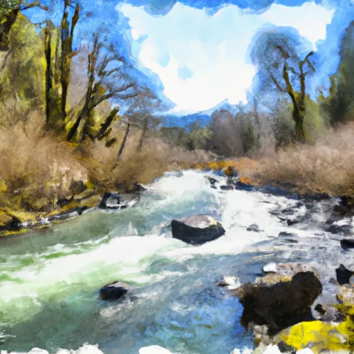
The river is surrounded by beautiful scenery, including lush forests, granite cliffs, and moss-covered rocks. The area is also home to diverse wildlife, including salmon, steelhead, and various bird species. The Oregon State Parks and Recreation Department manages the river, and visitors are required to obtain permits from the department before accessing the site.
Visitors must also adhere to various rules and regulations while on the river. For instance, all boats must carry a personal flotation device for each person on board, and alcohol is strictly prohibited. Additionally, visitors are required to pack out all their trash and leave the riverbank and surrounding area clean.
In conclusion, Lobster Creek is an exciting river run that offers visitors the opportunity to experience the beauty of Oregon's wilderness. With its ideal streamflow range, class III rating, and diverse rapids and obstacles, the river is an excellent destination for both experienced and novice rafters and kayakers. Visitors should, however, ensure they follow all regulations and leave the area clean to maintain the natural beauty of the river.
Plan your run down to the hour
Same weather feed Snoflo's iOS app uses -- updated continuously from NOAA / yr.no. Watch the precipitation column on the meteogram; rain ahead of a run typically lifts flows 12-48 hours later depending on the basin.
Next 5 days, hour by hour
Temperature line with weather symbols on top, snow + rain accumulation as columns, humidity as a dotted line.
5-day forecast table
Every 3 hours, broken out across temperature, snow, rain, humidity, and wind. Each cell is colour-coded relative to the column min/max.
| Time | Condition | Temp (°F) | Snow (in) | Rain (in) | Humidity (%) | Wind (mps) | Wind dir |
|---|---|---|---|---|---|---|---|
| Loading detailed forecast… | |||||||
15-day temperature & precipitation
Daily temperatures, snow, and rain projected over the next two weeks -- the upstream story that drives next week's flows.
Regional streamflow levels
USGS streamgauges around Lobster Creek -- useful for spotting upstream pulses and gauging which tributary is contributing what.
| Streamgauge | Discharge | View |
|---|---|---|
| East Fork Lobster Creek Near Alsea | 1 cfs | → |
| Alsea River Near Tidewater | 81 cfs | → |
| Long Tom River At Monroe | 50 cfs | → |
| Siuslaw River Near Mapleton | 107 cfs | → |
| Long Tom River Near Noti | 14 cfs | → |
| Long Tom River Near Alvadore | 62 cfs | → |
Plan a longer trip
The closest boat launches, other paddle runs, and campgrounds so a day on the water can grow into a full weekend.
Boat launches
Other river runs
Campgrounds
- Salmonberry County Park Campground
- Upper Lake Creek
- Upper Lake Creek Dispersed Camping
- Hult Pond - Dispersed
- Alsea Falls
- Alsea Falls Recreation Site
Parks
Whitewater safety
- Check the flow before you run
- Use the linked-gauge card and Regional Flow panel above. Class ratings change with flow -- a Class III at low water can become Class IV+ at high water.
- Know your skill ceiling
- Pick runs comfortably below your ceiling. Cold-water and big-water runs raise the consequences of any mistake.
- Wear the right gear
- Helmet, PFD, drysuit / wetsuit when water is below 60°F. Throw bag, knife, and whistle on your person, not in the boat.
- Scout, set safety, and run with a team
- Scout new rapids on foot, set safety with throw bags above the consequence pool, and run with at least one other competent paddler.
- Respect the river
- Strainers, undercuts, low-head dams, and wood can kill at any class rating. When in doubt, portage.
Set push alerts in the Snoflo app
Save Lobster Creek as a favorite, set a discharge threshold (e.g. "alert me when flow hits 600 cfs"), and the iOS app pushes the moment the linked gauge crosses.
About Lobster Creek
What's the optimal flow for Lobster Creek?
The optimal flow depends on the section and the craft. Check the Run Details panel for the linked gauge and current status.
How fresh is the cfs reading on this page?
The linked USGS streamgauge reports continuously (every 15 minutes); Snoflo refreshes throughout the day. Hover the streamflow sparkline to read individual datapoints.
What's the whitewater class?
See the Run Details panel for the class rating Snoflo tracks for this run. Class ratings change with flow -- a Class III at low water can become Class IV in high water.
Where do I put in / take out?
Tap Directions in the hero above to open driving directions to the put-in. For shuttle planning, check the Nearby Boat Launches panel and the river run operator's site.
Can I get alerts when flows hit the optimal range?
Yes -- alerts are managed in the Snoflo iOS app. Favorite this run, set a discharge threshold, and you'll get a push the moment the gauge crosses.
Other runs near here
Snoflo-tracked paddle runs within driving distance of Lobster Creek.