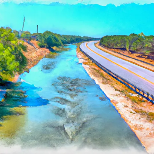
Us Highway 59 To Us Highway 69 River Run
Community Reviews
Been here? Share the conditions.
Reviews, ratings & photos are added in the free Snoflo iOS app — rate a spot, tag the conditions, and your visit is verified by location. Add or manage your reviews from the app.
Us Highway 59 To Us Highway 69
The segment mileage for this river run is approximately 4.5 miles. The river rapids/obstacles include several drops, waves, and ledges. One notable rapid is called "The Maze," which requires precise navigation through a series of rocks.
Specific regulations for the area include the mandatory use of personal flotation devices (PFDs) for all paddlers and the requirement of a river access permit. The river access permit can be obtained from the Texas Parks and Wildlife Department.
In conclusion, the Whitewater River Run in Texas is a Class II-III river suitable for intermediate paddlers. The ideal streamflow range is between 300-500 cfs, and the segment mileage is approximately 4.5 miles. Paddlers must adhere to specific regulations, including the use of PFDs and obtaining a river access permit.
Plan your run down to the hour
Same weather feed Snoflo's iOS app uses -- updated continuously from NOAA / yr.no. Watch the precipitation column on the meteogram; rain ahead of a run typically lifts flows 12-48 hours later depending on the basin.
Next 5 days, hour by hour
Temperature line with weather symbols on top, snow + rain accumulation as columns, humidity as a dotted line.
5-day forecast table
Every 3 hours, broken out across temperature, snow, rain, humidity, and wind. Each cell is colour-coded relative to the column min/max.
| Time | Condition | Temp (°F) | Snow (in) | Rain (in) | Humidity (%) | Wind (mps) | Wind dir |
|---|---|---|---|---|---|---|---|
| Loading detailed forecast… | |||||||
15-day temperature & precipitation
Daily temperatures, snow, and rain projected over the next two weeks -- the upstream story that drives next week's flows.
Regional streamflow levels
USGS streamgauges around Us Highway 59 To Us Highway 69 -- useful for spotting upstream pulses and gauging which tributary is contributing what.
| Streamgauge | Discharge | View |
|---|---|---|
| Neches Rv Nr Rockland | 498 cfs | → |
| Neches Rv Nr Diboll | 441 cfs | → |
| Neches Rv Nr Town Bluff | 2,850 cfs | → |
| Ayish Bayou Nr San Augustine | 103 cfs | → |
| Attoyac Bayou Nr Chireno | 1,010 cfs | → |
| Long King Ck At Livingston | 10 cfs | → |
Plan a longer trip
The closest boat launches, other paddle runs, and campgrounds so a day on the water can grow into a full weekend.
Boat launches
- Highway 255 Bridge
- Farm To Market Road 3124, Zavalla
- Caney Creek Park
- Cassells-Boykin Park (West)
- Boat Ramp Road
- Cassells-Boykin Park (East)
Other river runs
- Us Highway 69 To Ba Steinhagen Reservoir
- State Highway 7 To Us Highway 59
- Town Bluff Dam To Hwy 96 Bridge
- Preserve Boundary Of The Big Sandy Unit To Confluence With Village Creek
- Preserve Boundary In The Big Sandy Unit To Confluence With Big Sandy Creek
Campgrounds
- Bouton Lake
- Bouton Lake Campground
- Lake Tejas City Park
- Boykin Springs: (936) 897-1068
- Boykin Springs Recreation Area
- Boykin Spring
Fishing spots
Whitewater safety
- Check the flow before you run
- Use the linked-gauge card and Regional Flow panel above. Class ratings change with flow -- a Class III at low water can become Class IV+ at high water.
- Know your skill ceiling
- Pick runs comfortably below your ceiling. Cold-water and big-water runs raise the consequences of any mistake.
- Wear the right gear
- Helmet, PFD, drysuit / wetsuit when water is below 60°F. Throw bag, knife, and whistle on your person, not in the boat.
- Scout, set safety, and run with a team
- Scout new rapids on foot, set safety with throw bags above the consequence pool, and run with at least one other competent paddler.
- Respect the river
- Strainers, undercuts, low-head dams, and wood can kill at any class rating. When in doubt, portage.
Set push alerts in the Snoflo app
Save Us Highway 59 To Us Highway 69 as a favorite, set a discharge threshold (e.g. "alert me when flow hits 600 cfs"), and the iOS app pushes the moment the linked gauge crosses.
About Us Highway 59 To Us Highway 69
What's the optimal flow for Us Highway 59 To Us Highway 69?
The optimal flow depends on the section and the craft. Check the Run Details panel for the linked gauge and current status.
How fresh is the cfs reading on this page?
The linked USGS streamgauge reports continuously (every 15 minutes); Snoflo refreshes throughout the day. Hover the streamflow sparkline to read individual datapoints.
What's the whitewater class?
See the Run Details panel for the class rating Snoflo tracks for this run. Class ratings change with flow -- a Class III at low water can become Class IV in high water.
Where do I put in / take out?
Tap Directions in the hero above to open driving directions to the put-in. For shuttle planning, check the Nearby Boat Launches panel and the river run operator's site.
Can I get alerts when flows hit the optimal range?
Yes -- alerts are managed in the Snoflo iOS app. Favorite this run, set a discharge threshold, and you'll get a push the moment the gauge crosses.
Other runs near here
Snoflo-tracked paddle runs within driving distance of Us Highway 59 To Us Highway 69.