Boundary Of Glen Canyon National Recreation Area To Confluence With San Juan River River Run
Community Reviews
Been here? Share the conditions.
Reviews, ratings & photos are added in the free Snoflo iOS app — rate a spot, tag the conditions, and your visit is verified by location. Add or manage your reviews from the app.
Boundary Of Glen Canyon National Recreation Area To Confluence With San Juan River
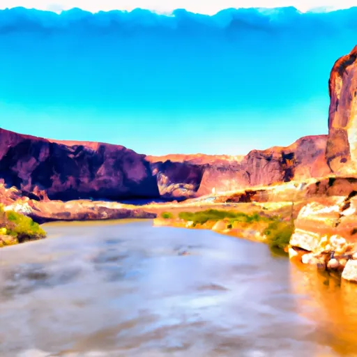
The Whitewater River Run on the Colorado River runs from the boundary of Glen Canyon National Recreation Area to the confluence with the San Juan River in Utah. The ideal streamflow range for this run is between 10,000 and 25,000 cubic feet per second (cfs). This range provides the best water flow for an enjoyable and exciting ride.
The class rating for the Whitewater River Run is rated as Class III to Class IV, which means it is suitable for intermediate to advanced paddlers with previous whitewater experience. The segment mileage of this run is approximately 26 miles, with rapids and obstacles scattered throughout the stretch of water.
Specific rapids on this run include Badger Creek Rapid, Soap Creek Rapid, and Government Rapid. These rapids vary in difficulty but are generally challenging and require skillful navigation. Some obstacles include rocks, eddies, and strong currents.
There are specific regulations in place for this area to ensure the safety of visitors and the preservation of the natural environment. Visitors must obtain a permit before entering the Glen Canyon National Recreation Area, and it is essential to follow all rules and regulations set forth by the National Park Service. Additionally, visitors are encouraged to pack out all trash and respect the natural surroundings.
Overall, the Whitewater River Run is an exciting and challenging experience for experienced paddlers. It is important to respect the natural environment and follow all regulations to ensure a safe and enjoyable experience.
Plan your run down to the hour
Same weather feed Snoflo's iOS app uses -- updated continuously from NOAA / yr.no. Watch the precipitation column on the meteogram; rain ahead of a run typically lifts flows 12-48 hours later depending on the basin.
Next 5 days, hour by hour
Temperature line with weather symbols on top, snow + rain accumulation as columns, humidity as a dotted line.
5-day forecast table
Every 3 hours, broken out across temperature, snow, rain, humidity, and wind. Each cell is colour-coded relative to the column min/max.
| Time | Condition | Temp (°F) | Snow (in) | Rain (in) | Humidity (%) | Wind (mps) | Wind dir |
|---|---|---|---|---|---|---|---|
| Loading detailed forecast… | |||||||
15-day temperature & precipitation
Daily temperatures, snow, and rain projected over the next two weeks -- the upstream story that drives next week's flows.
Regional streamflow levels
USGS streamgauges around Boundary Of Glen Canyon National Recreation Area To Confluence With San Juan River -- useful for spotting upstream pulses and gauging which tributary is contributing what.
| Streamgauge | Discharge | View |
|---|---|---|
| San Juan River Near Bluff | 817 cfs | → |
| Chinle Creek Near Mexican Water | 0 cfs | → |
| Dirty Devil R Abv Poison Sp Wash Nr Hanksville | 56 cfs | → |
| Recapture Creek Near Blanding | · | → |
| Colorado River At Lees Ferry | 9,020 cfs | → |
| Paria River At Lees Ferry | 4 cfs | → |
Plan a longer trip
The closest boat launches, other paddle runs, and campgrounds so a day on the water can grow into a full weekend.
Boat launches
Other river runs
- Mexican Hat To Clay Hills
- Eastern Boundary Of Glen Canyon National Recreation Area To Confluence With Lake Powell
- Headwaters In T41s R11e To Confluence With San Juan River
- Headwaters At T41s, R10e To Confluence With San Juan River
Campgrounds
Whitewater safety
- Check the flow before you run
- Use the linked-gauge card and Regional Flow panel above. Class ratings change with flow -- a Class III at low water can become Class IV+ at high water.
- Know your skill ceiling
- Pick runs comfortably below your ceiling. Cold-water and big-water runs raise the consequences of any mistake.
- Wear the right gear
- Helmet, PFD, drysuit / wetsuit when water is below 60°F. Throw bag, knife, and whistle on your person, not in the boat.
- Scout, set safety, and run with a team
- Scout new rapids on foot, set safety with throw bags above the consequence pool, and run with at least one other competent paddler.
- Respect the river
- Strainers, undercuts, low-head dams, and wood can kill at any class rating. When in doubt, portage.
Set push alerts in the Snoflo app
Save Boundary Of Glen Canyon National Recreation Area To Confluence With San Juan River as a favorite, set a discharge threshold (e.g. "alert me when flow hits 600 cfs"), and the iOS app pushes the moment the linked gauge crosses.
About Boundary Of Glen Canyon National Recreation Area To Confluence With San Juan River
What's the optimal flow for Boundary Of Glen Canyon National Recreation Area To Confluence With San Juan River?
The optimal flow depends on the section and the craft. Check the Run Details panel for the linked gauge and current status.
How fresh is the cfs reading on this page?
The linked USGS streamgauge reports continuously (every 15 minutes); Snoflo refreshes throughout the day. Hover the streamflow sparkline to read individual datapoints.
What's the whitewater class?
See the Run Details panel for the class rating Snoflo tracks for this run. Class ratings change with flow -- a Class III at low water can become Class IV in high water.
Where do I put in / take out?
Tap Directions in the hero above to open driving directions to the put-in. For shuttle planning, check the Nearby Boat Launches panel and the river run operator's site.
Can I get alerts when flows hit the optimal range?
Yes -- alerts are managed in the Snoflo iOS app. Favorite this run, set a discharge threshold, and you'll get a push the moment the gauge crosses.
Other runs near here
Snoflo-tracked paddle runs within driving distance of Boundary Of Glen Canyon National Recreation Area To Confluence With San Juan River.