Headwaters At T41s, R10e To Confluence With San Juan River River Run
Community Reviews
Been here? Share the conditions.
Reviews, ratings & photos are added in the free Snoflo iOS app — rate a spot, tag the conditions, and your visit is verified by location. Add or manage your reviews from the app.
Headwaters At T41s, R10e To Confluence With San Juan River
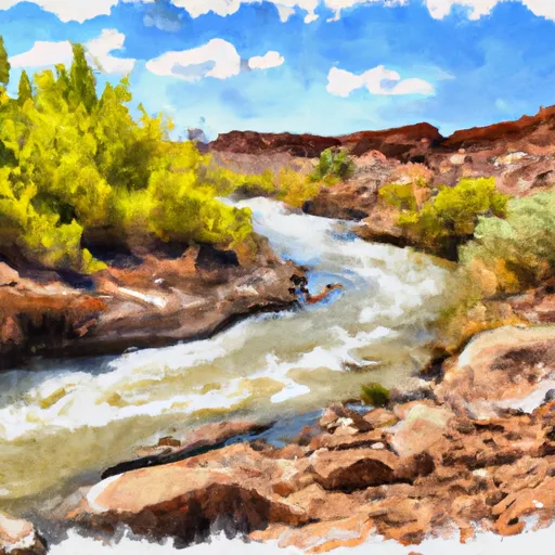
Some of the specific rapids and obstacles on this run include the Rapidian, a Class III rapid with a large rock in the middle that requires precise navigation. Another challenging rapid is the Corkscrew, a Class IV chute that requires advanced maneuvering skills. Other notable rapids include Slickhorn and Government Rapid.
There are some specific regulations that apply to this area, such as the requirement to obtain a permit from the Bureau of Land Management (BLM) to access the river. The BLM also enforces rules regarding camping and fire restrictions. Additionally, boaters are required to follow Leave No Trace principles to help preserve the natural beauty of the area.
Overall, the Whitewater River Run is a challenging and rewarding adventure for experienced kayakers and rafters, and it is important to follow regulations and safety guidelines to ensure a successful trip.
Plan your run down to the hour
Same weather feed Snoflo's iOS app uses -- updated continuously from NOAA / yr.no. Watch the precipitation column on the meteogram; rain ahead of a run typically lifts flows 12-48 hours later depending on the basin.
Next 5 days, hour by hour
Temperature line with weather symbols on top, snow + rain accumulation as columns, humidity as a dotted line.
5-day forecast table
Every 3 hours, broken out across temperature, snow, rain, humidity, and wind. Each cell is colour-coded relative to the column min/max.
| Time | Condition | Temp (°F) | Snow (in) | Rain (in) | Humidity (%) | Wind (mps) | Wind dir |
|---|---|---|---|---|---|---|---|
| Loading detailed forecast… | |||||||
15-day temperature & precipitation
Daily temperatures, snow, and rain projected over the next two weeks -- the upstream story that drives next week's flows.
Regional streamflow levels
USGS streamgauges around Headwaters At T41s, R10e To Confluence With San Juan River -- useful for spotting upstream pulses and gauging which tributary is contributing what.
| Streamgauge | Discharge | View |
|---|---|---|
| Colorado River At Lees Ferry | 9,020 cfs | → |
| Paria River At Lees Ferry | 4 cfs | → |
| San Juan River Near Bluff | 817 cfs | → |
| Escalante River Near Escalante | 1 cfs | → |
| Paria River Near Kanab | 2 cfs | → |
| Pine Creek Near Escalante | 0 cfs | → |
Plan a longer trip
The closest boat launches, other paddle runs, and campgrounds so a day on the water can grow into a full weekend.
Other river runs
- Headwaters In T41s R11e To Confluence With San Juan River
- Headwaters At T39s, R9e To Confluence With Escalante River
- Headwaters To Confluence With Colorado River
- Fence Canyon
- Headwaters At T39s, R9e To Confluence With Escalante River
Campgrounds
Whitewater safety
- Check the flow before you run
- Use the linked-gauge card and Regional Flow panel above. Class ratings change with flow -- a Class III at low water can become Class IV+ at high water.
- Know your skill ceiling
- Pick runs comfortably below your ceiling. Cold-water and big-water runs raise the consequences of any mistake.
- Wear the right gear
- Helmet, PFD, drysuit / wetsuit when water is below 60°F. Throw bag, knife, and whistle on your person, not in the boat.
- Scout, set safety, and run with a team
- Scout new rapids on foot, set safety with throw bags above the consequence pool, and run with at least one other competent paddler.
- Respect the river
- Strainers, undercuts, low-head dams, and wood can kill at any class rating. When in doubt, portage.
Set push alerts in the Snoflo app
Save Headwaters At T41s, R10e To Confluence With San Juan River as a favorite, set a discharge threshold (e.g. "alert me when flow hits 600 cfs"), and the iOS app pushes the moment the linked gauge crosses.
About Headwaters At T41s, R10e To Confluence With San Juan River
What's the optimal flow for Headwaters At T41s, R10e To Confluence With San Juan River?
The optimal flow depends on the section and the craft. Check the Run Details panel for the linked gauge and current status.
How fresh is the cfs reading on this page?
The linked USGS streamgauge reports continuously (every 15 minutes); Snoflo refreshes throughout the day. Hover the streamflow sparkline to read individual datapoints.
What's the whitewater class?
See the Run Details panel for the class rating Snoflo tracks for this run. Class ratings change with flow -- a Class III at low water can become Class IV in high water.
Where do I put in / take out?
Tap Directions in the hero above to open driving directions to the put-in. For shuttle planning, check the Nearby Boat Launches panel and the river run operator's site.
Can I get alerts when flows hit the optimal range?
Yes -- alerts are managed in the Snoflo iOS app. Favorite this run, set a discharge threshold, and you'll get a push the moment the gauge crosses.
Other runs near here
Snoflo-tracked paddle runs within driving distance of Headwaters At T41s, R10e To Confluence With San Juan River.