Segment C--Southern Boundary Hidden Valley Tract To Mcclintic Bridge River Run
Community Reviews
Been here? Share the conditions.
Reviews, ratings & photos are added in the free Snoflo iOS app — rate a spot, tag the conditions, and your visit is verified by location. Add or manage your reviews from the app.
Segment C--Southern Boundary Hidden Valley Tract To Mcclintic Bridge
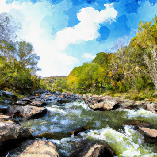
Some of the notable rapids and obstacles on this segment include the "Crack in the Rock," "Hidden Valley Rapid," and "Maytag." These rapids require experienced paddlers to navigate through them safely. The "Crack in the Rock" is a narrow channel that requires precise maneuvering to avoid getting stuck. The "Hidden Valley Rapid" offers a steep drop and strong currents that can create large waves. The "Maytag" is a swirling hydraulic that can easily flip inexperienced paddlers.
To ensure safety and preserve the natural environment, the Virginia Department of Game and Inland Fisheries has specific regulations for this area. Paddlers are required to wear life jackets and helmets at all times while on the water. Additionally, it is prohibited to remove or disturb any natural materials, including rocks and vegetation, along the riverbank.
Plan your run down to the hour
Same weather feed Snoflo's iOS app uses -- updated continuously from NOAA / yr.no. Watch the precipitation column on the meteogram; rain ahead of a run typically lifts flows 12-48 hours later depending on the basin.
Next 5 days, hour by hour
Temperature line with weather symbols on top, snow + rain accumulation as columns, humidity as a dotted line.
5-day forecast table
Every 3 hours, broken out across temperature, snow, rain, humidity, and wind. Each cell is colour-coded relative to the column min/max.
| Time | Condition | Temp (°F) | Snow (in) | Rain (in) | Humidity (%) | Wind (mps) | Wind dir |
|---|---|---|---|---|---|---|---|
| Loading detailed forecast… | |||||||
15-day temperature & precipitation
Daily temperatures, snow, and rain projected over the next two weeks -- the upstream story that drives next week's flows.
Regional streamflow levels
USGS streamgauges around Segment C--Southern Boundary Hidden Valley Tract To Mcclintic Bridge -- useful for spotting upstream pulses and gauging which tributary is contributing what.
| Streamgauge | Discharge | View |
|---|---|---|
| Back Creek Near Mountain Grove | 32 cfs | → |
| Jackson River Near Bacova | 25 cfs | → |
| Back Creek At Sunrise | 26 cfs | → |
| Little Back Creek Near Sunrise | 4 cfs | → |
| Back Creek Near Sunrise | 6 cfs | → |
| Jackson River Bl Gathright Dam Nr Hot Spgs | 240 cfs | → |
Plan a longer trip
The closest boat launches, other paddle runs, and campgrounds so a day on the water can grow into a full weekend.
Boat launches
- Lake Moomaw Marina
- Lake Sherwood Road Greenbrier County
- Walton Tract Canoe Access Point
- Coles Point
- Douthat State Park Road Bath County
- Lake Moomaw (Coles Point)
Other river runs
- Segment A--State Route 39 At Blowing Springs Campground To Lake Moomaw
- Segment B--Northern Boundary, Hidden Valley Tract To Southern Boundary Of Hidden Valley Tract
- Segment B--Pump Storage Lake To Blowing Springs Campground
- Segment B--Confluence With Bullpasture River To Route 42 Bridge
- Ford Where Route 609 Departs From Route 678 To Confluence With Cowpasture River
Campgrounds
- Hidden Valley Recreation Area
- Blowing Springs
- Blowing Springs Campground
- Mcclintic Point
- Pocahontas Campground
- Pocahontas
Parks
Whitewater safety
- Check the flow before you run
- Use the linked-gauge card and Regional Flow panel above. Class ratings change with flow -- a Class III at low water can become Class IV+ at high water.
- Know your skill ceiling
- Pick runs comfortably below your ceiling. Cold-water and big-water runs raise the consequences of any mistake.
- Wear the right gear
- Helmet, PFD, drysuit / wetsuit when water is below 60°F. Throw bag, knife, and whistle on your person, not in the boat.
- Scout, set safety, and run with a team
- Scout new rapids on foot, set safety with throw bags above the consequence pool, and run with at least one other competent paddler.
- Respect the river
- Strainers, undercuts, low-head dams, and wood can kill at any class rating. When in doubt, portage.
Set push alerts in the Snoflo app
Save Segment C--Southern Boundary Hidden Valley Tract To Mcclintic Bridge as a favorite, set a discharge threshold (e.g. "alert me when flow hits 600 cfs"), and the iOS app pushes the moment the linked gauge crosses.
About Segment C--Southern Boundary Hidden Valley Tract To Mcclintic Bridge
What's the optimal flow for Segment C--Southern Boundary Hidden Valley Tract To Mcclintic Bridge?
The optimal flow depends on the section and the craft. Check the Run Details panel for the linked gauge and current status.
How fresh is the cfs reading on this page?
The linked USGS streamgauge reports continuously (every 15 minutes); Snoflo refreshes throughout the day. Hover the streamflow sparkline to read individual datapoints.
What's the whitewater class?
See the Run Details panel for the class rating Snoflo tracks for this run. Class ratings change with flow -- a Class III at low water can become Class IV in high water.
Where do I put in / take out?
Tap Directions in the hero above to open driving directions to the put-in. For shuttle planning, check the Nearby Boat Launches panel and the river run operator's site.
Can I get alerts when flows hit the optimal range?
Yes -- alerts are managed in the Snoflo iOS app. Favorite this run, set a discharge threshold, and you'll get a push the moment the gauge crosses.
Other runs near here
Snoflo-tracked paddle runs within driving distance of Segment C--Southern Boundary Hidden Valley Tract To Mcclintic Bridge.