Headwaters And Includes All Tributaries To Confluence With Hoh River River Run
Community Reviews
Been here? Share the conditions.
Reviews, ratings & photos are added in the free Snoflo iOS app — rate a spot, tag the conditions, and your visit is verified by location. Add or manage your reviews from the app.
Headwaters And Includes All Tributaries To Confluence With Hoh River
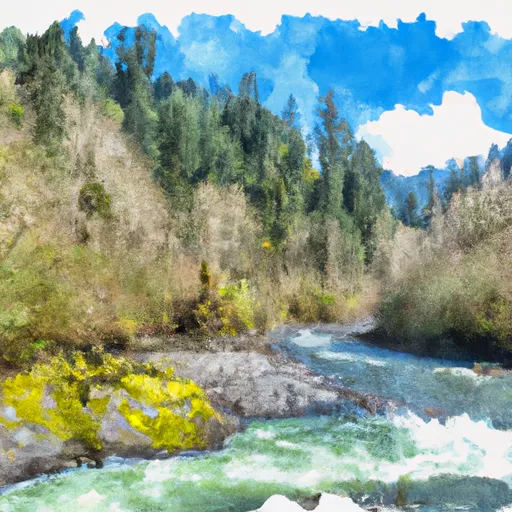
The run spans over 10.5 miles, starting at the confluence of the East Fork and West Fork of the river and ending at the confluence with the Hoh River. The first 4 miles consist of mostly Class I-II rapids, followed by a 2-mile section of Class III rapids at Kimmel Fork. The remaining 4.5 miles include a mixture of Class III-IV rapids and calm stretches.
The Whitewater River Run includes several specific rapids and obstacles, including Kimmel Fork, which is known for its large waves and challenging drops. Other notable rapids include Triple Drop, which features three consecutive drops, and Fangorn, which has a narrow chute and a tight turn.
There are specific regulations in place for the Whitewater River Run to ensure the safety of participants and protect the natural environment. Rafters are required to wear personal flotation devices and helmets, and commercial outfitters must have permits and follow guidelines set by the National Park Service.
In conclusion, the Whitewater River Run in Washington state offers a thrilling white-water rafting experience with a variety of rapids and challenges. The ideal streamflow range, class rating, segment mileage, specific rapids, and regulations make it a popular and safe destination for rafters of intermediate to advanced skill levels.
Plan your run down to the hour
Same weather feed Snoflo's iOS app uses -- updated continuously from NOAA / yr.no. Watch the precipitation column on the meteogram; rain ahead of a run typically lifts flows 12-48 hours later depending on the basin.
Next 5 days, hour by hour
Temperature line with weather symbols on top, snow + rain accumulation as columns, humidity as a dotted line.
5-day forecast table
Every 3 hours, broken out across temperature, snow, rain, humidity, and wind. Each cell is colour-coded relative to the column min/max.
| Time | Condition | Temp (°F) | Snow (in) | Rain (in) | Humidity (%) | Wind (mps) | Wind dir |
|---|---|---|---|---|---|---|---|
| Loading detailed forecast… | |||||||
15-day temperature & precipitation
Daily temperatures, snow, and rain projected over the next two weeks -- the upstream story that drives next week's flows.
Regional streamflow levels
USGS streamgauges around Headwaters And Includes All Tributaries To Confluence With Hoh River -- useful for spotting upstream pulses and gauging which tributary is contributing what.
| Streamgauge | Discharge | View |
|---|---|---|
| Elwha River Above Lake Mills Nr Port Angeles | 725 cfs | → |
| Elwha River At Mcdonald Br Near Port Angeles | 395 cfs | → |
| Hoh River At Us Highway 101 Near Forks | 685 cfs | → |
| Dungeness River Near Sequim | 131 cfs | → |
| Quinault River At Quinault Lake | 486 cfs | → |
| Calawah River Near Forks | 100 cfs | → |
Plan a longer trip
The closest boat launches, other paddle runs, and campgrounds so a day on the water can grow into a full weekend.
Other river runs
- Headwaters And Includes All Tributaries To Confluence With Sol Duc River
- Headwaters And Includes All Tributaries Within The Park To Confluence With Sol Duc River
Whitewater safety
- Check the flow before you run
- Use the linked-gauge card and Regional Flow panel above. Class ratings change with flow -- a Class III at low water can become Class IV+ at high water.
- Know your skill ceiling
- Pick runs comfortably below your ceiling. Cold-water and big-water runs raise the consequences of any mistake.
- Wear the right gear
- Helmet, PFD, drysuit / wetsuit when water is below 60°F. Throw bag, knife, and whistle on your person, not in the boat.
- Scout, set safety, and run with a team
- Scout new rapids on foot, set safety with throw bags above the consequence pool, and run with at least one other competent paddler.
- Respect the river
- Strainers, undercuts, low-head dams, and wood can kill at any class rating. When in doubt, portage.
Set push alerts in the Snoflo app
Save Headwaters And Includes All Tributaries To Confluence With Hoh River as a favorite, set a discharge threshold (e.g. "alert me when flow hits 600 cfs"), and the iOS app pushes the moment the linked gauge crosses.
About Headwaters And Includes All Tributaries To Confluence With Hoh River
What's the optimal flow for Headwaters And Includes All Tributaries To Confluence With Hoh River?
The optimal flow depends on the section and the craft. Check the Run Details panel for the linked gauge and current status.
How fresh is the cfs reading on this page?
The linked USGS streamgauge reports continuously (every 15 minutes); Snoflo refreshes throughout the day. Hover the streamflow sparkline to read individual datapoints.
What's the whitewater class?
See the Run Details panel for the class rating Snoflo tracks for this run. Class ratings change with flow -- a Class III at low water can become Class IV in high water.
Where do I put in / take out?
Tap Directions in the hero above to open driving directions to the put-in. For shuttle planning, check the Nearby Boat Launches panel and the river run operator's site.
Can I get alerts when flows hit the optimal range?
Yes -- alerts are managed in the Snoflo iOS app. Favorite this run, set a discharge threshold, and you'll get a push the moment the gauge crosses.
Other runs near here
Snoflo-tracked paddle runs within driving distance of Headwaters And Includes All Tributaries To Confluence With Hoh River.