Headwaters And Includes All Tributaries To Confluence With Graves Creek river run
Community Reviews
Been here? Share the conditions.
Reviews, ratings & photos are added in the free Snoflo iOS app — rate a spot, tag the conditions, and your visit is verified by location. Add or manage your reviews from the app.
Headwaters And Includes All Tributaries To Confluence With Graves Creek
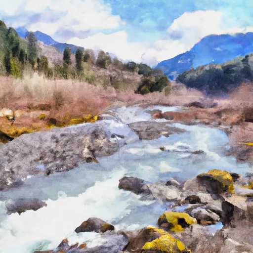
There are specific river rapids and obstacles that make this river run exciting and challenging. Some of the notable rapids include Boulder Drop, Hammering Spot, and Snowblind. These rapids require advanced skills in navigating technical water and fast-moving rapids. The river also has several large boulders and steep drops that add to the excitement of the run.
There are specific regulations to the area that must be followed to ensure safety. All rafters must wear a personal flotation device (PFD) at all times on the river. Additionally, all rafts must be equipped with a throw rope, first aid kit, and repair kit. Rafters must also be experienced in white-water rafting and have the necessary skills to navigate the river safely.
Overall, the Whitewater River Run is an exciting and challenging river run that is not for the faint of heart. It is recommended that only experienced white-water rafters attempt this run and that all safety regulations are followed to ensure a safe and thrilling experience.
Plan your run down to the hour
Same weather feed Snoflo's iOS app uses -- updated continuously from NOAA / yr.no. Watch the precipitation column on the meteogram; rain ahead of a run typically lifts flows 12-48 hours later depending on the basin.
Next 5 days, hour by hour
Temperature line with weather symbols on top, snow + rain accumulation as columns, humidity as a dotted line.
5-day forecast table
Every 3 hours, broken out across temperature, snow, rain, humidity, and wind. Each cell is colour-coded relative to the column min/max.
| Time | Condition | Temp (°F) | Snow (in) | Rain (in) | Humidity (%) | Wind (mps) | Wind dir |
|---|---|---|---|---|---|---|---|
| Loading detailed forecast… | |||||||
15-day temperature & precipitation
Daily temperatures, snow, and rain projected over the next two weeks -- the upstream story that drives next week's flows.
Regional streamflow levels
USGS streamgauges around Headwaters And Includes All Tributaries To Confluence With Graves Creek -- useful for spotting upstream pulses and gauging which tributary is contributing what.
| Streamgauge | Discharge | View |
|---|---|---|
| Nf Skokomish R Bl Staircase Rpds Nr Hoodsport | 52 cfs | → |
| Wynoochee River Near Grisdale | 235 cfs | → |
| South Fork Skokomish River Near Union | 116 cfs | → |
| North Fork Skokomish River Near Potlatch | 154 cfs | → |
| Wynoochee River Above Save Creek Near Aberdeen | 263 cfs | → |
| Quinault River At Quinault Lake | 481 cfs | → |
Plan a longer trip
The closest boat launches, other paddle runs, and campgrounds so a day on the water can grow into a full weekend.
Boat launches
- National Forest Development Road 2294, Montesano
- Lake Cushman State Park
- N Deer Lane W
- Dow Creek Drive
- South Shore Road 419, Quinault
Other river runs
- Headwaters- Includes All Tributaries To Confluence With North Fork Skokomish River
- Headwaters To Southern Boundary Of Olympic National Park
- Headwaters And Includes All Tributaries To Confluence With Quinault River
Campgrounds
Whitewater safety
- Check the flow before you run
- Use the linked-gauge card and Regional Flow panel above. Class ratings change with flow -- a Class III at low water can become Class IV+ at high water.
- Know your skill ceiling
- Pick runs comfortably below your ceiling. Cold-water and big-water runs raise the consequences of any mistake.
- Wear the right gear
- Helmet, PFD, drysuit / wetsuit when water is below 60°F. Throw bag, knife, and whistle on your person, not in the boat.
- Scout, set safety, and run with a team
- Scout new rapids on foot, set safety with throw bags above the consequence pool, and run with at least one other competent paddler.
- Respect the river
- Strainers, undercuts, low-head dams, and wood can kill at any class rating. When in doubt, portage.
Set push alerts in the Snoflo app
Save Headwaters And Includes All Tributaries To Confluence With Graves Creek as a favorite, set a discharge threshold (e.g. "alert me when flow hits 600 cfs"), and the iOS app pushes the moment the linked gauge crosses.
About Headwaters And Includes All Tributaries To Confluence With Graves Creek
What's the optimal flow for Headwaters And Includes All Tributaries To Confluence With Graves Creek?
The optimal flow depends on the section and the craft. Check the Run Details panel for the linked gauge and current status.
How fresh is the cfs reading on this page?
The linked USGS streamgauge reports continuously (every 15 minutes); Snoflo refreshes throughout the day. Hover the streamflow sparkline to read individual datapoints.
What's the whitewater class?
See the Run Details panel for the class rating Snoflo tracks for this run. Class ratings change with flow -- a Class III at low water can become Class IV in high water.
Where do I put in / take out?
Tap Directions in the hero above to open driving directions to the put-in. For shuttle planning, check the Nearby Boat Launches panel and the river run operator's site.
Can I get alerts when flows hit the optimal range?
Yes -- alerts are managed in the Snoflo iOS app. Favorite this run, set a discharge threshold, and you'll get a push the moment the gauge crosses.
Other runs near here
Snoflo-tracked paddle runs within driving distance of Headwaters And Includes All Tributaries To Confluence With Graves Creek.