Summary
The ideal streamflow range for this run is between 800 and 4000 cfs, providing the perfect balance of challenging rapids and navigable sections. The class rating for the Whitewater River Run is a mixture of class II-IV rapids, offering a range of difficulty for rafters and kayakers.
This run spans a distance of 20 miles, from the headwaters at 2800 ft to the western boundary of Olympic National Park. It is known for its beautiful scenery, including old-growth forests and stunning waterfalls. However, this run also presents a number of challenging rapids and obstacles, including the infamous "Brain Damage" rapid and "Hole in the Wall" rapid.
To ensure the safety of all visitors, there are specific regulations in place for the Whitewater River Run. All boaters must have a valid permit to access the river, and it is recommended that visitors check local weather and river conditions before embarking on their journey. Additionally, visitors are required to follow Leave No Trace principles and properly dispose of all waste.
Overall, the Whitewater River Run offers an exciting and challenging experience for those seeking to test their skills on the rapids. However, visitors should always prioritize safety and follow all regulations to ensure a successful trip.
°F
°F
mph
Wind
%
Humidity
15-Day Weather Outlook
River Run Details
| Last Updated | 2026-02-07 |
| River Levels | 1890 cfs (3.17 ft) |
| Percent of Normal | 64% |
| Status | |
| Class Level | ii-iv |
| Elevation | ft |
| Run Length | 17.0 Mi |
| Streamflow Discharge | cfs |
| Gauge Height | ft |
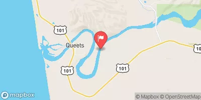
| Reporting Streamgage | USGS 12041200 |
5-Day Hourly Forecast Detail
Nearby Streamflow Levels
 Hoh River At Us Highway 101 Near Forks
|
2370cfs |
 Elwha River Above Lake Mills Nr Port Angeles
|
725cfs |
 Calawah River Near Forks
|
1110cfs |
 Elwha River At Mcdonald Br Near Port Angeles
|
1680cfs |
 Hoko River Near Sekiu
|
369cfs |
 Queets River Near Clearwater
|
3740cfs |
Area Campgrounds
| Location | Reservations | Toilets |
|---|---|---|
 Mink Lake Campground
|
||
 Sol Duc
|
||
 Sol Duc - Olympic National Park
|
||
 Hoh Rain Forest
|
||
 Mount Tom Creek Campsites
|
||
 Deer Lake Campground
|
River Runs
-
 Headwaters At 2800 Ft To Western Boundary Of Olympic National Park
-
 Headwaters And Includes All Tributaries To Confluence With North Fork Bogachiel River
-
 Headwaters And Includes All Tributaries Within The Park To Confluence With Sol Duc River
-
 Headwaters And Includes All Tributaries To Confluence With Sol Duc River

