Outlet Of Snoqualmie Lake To Alpine Lakes Wilderness Boundary River Run
Community Reviews
Been here? Share the conditions.
Reviews, ratings & photos are added in the free Snoflo iOS app — rate a spot, tag the conditions, and your visit is verified by location. Add or manage your reviews from the app.
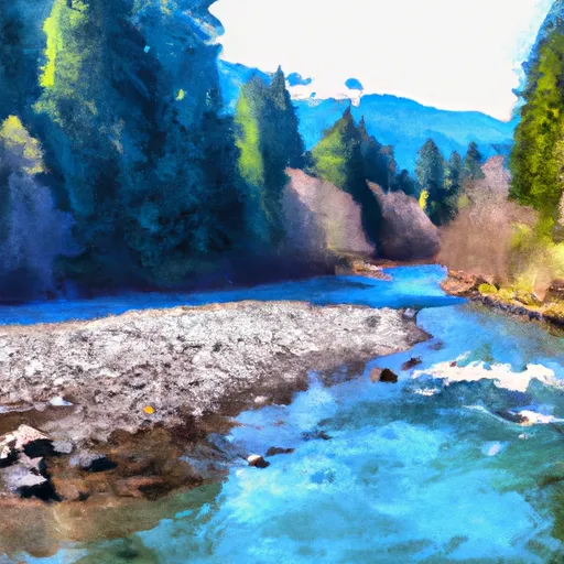
Outlet Of Snoqualmie Lake To Alpine Lakes Wilderness Boundary
Some of the specific rapids and obstacles to watch out for include "Pinball" and "S-Turns." The Pinball rapid is named for its resemblance to a pinball machine as the water bounces off of rocks and creates a challenging obstacle course. The S-Turns rapid is a series of sharp turns that require quick maneuvering.
There are specific regulations in place for this area, including a requirement for a permit to enter the Alpine Lakes Wilderness. Additionally, all motorized boats are prohibited on the river.
Plan your run down to the hour
Same weather feed Snoflo's iOS app uses -- updated continuously from NOAA / yr.no. Watch the precipitation column on the meteogram; rain ahead of a run typically lifts flows 12-48 hours later depending on the basin.
Next 5 days, hour by hour
Temperature line with weather symbols on top, snow + rain accumulation as columns, humidity as a dotted line.
5-day forecast table
Every 3 hours, broken out across temperature, snow, rain, humidity, and wind. Each cell is colour-coded relative to the column min/max.
| Time | Condition | Temp (°F) | Snow (in) | Rain (in) | Humidity (%) | Wind (mps) | Wind dir |
|---|---|---|---|---|---|---|---|
| Loading detailed forecast… | |||||||
15-day temperature & precipitation
Daily temperatures, snow, and rain projected over the next two weeks -- the upstream story that drives next week's flows.
Regional streamflow levels
USGS streamgauges around Outlet Of Snoqualmie Lake To Alpine Lakes Wilderness Boundary -- useful for spotting upstream pulses and gauging which tributary is contributing what.
| Streamgauge | Discharge | View |
|---|---|---|
| Middle Fork Snoqualmie River Near Tanner | 147 cfs | → |
| South Fork Tolt River Near Index | 3 cfs | → |
| Sf Snoqualmie River Ab Alice Creek Near Garcia | 34 cfs | → |
| Nf Snoqualmie River Near Snoqualmie Falls | 47 cfs | → |
| South Fork Tolt River Near Carnation | 65 cfs | → |
| Sf Snoqualmie River At Edgewick | 54 cfs | → |
Plan a longer trip
The closest boat launches, other paddle runs, and campgrounds so a day on the water can grow into a full weekend.
Boat launches
- King County
- Keechelus Lake Boat Launch
- Keechelus
- Cooper Lake Boat Launch
- Bakers Lane, Easton
- Scatter Creek Campground
Other river runs
- Lake Dorothy To Alpine Lakes Wilderness Boundary
- Alpine Lakes Wilderness Boundary To Quartz Creek Road
- Headwaters In Se1/4 Of Sec 31, T24 1/2n, R11e To Alpine Lakes Wilderness Boundary
- Quartz Road To Confluence With Middle Fork Snoqualmie River
- Alpine Lakes Wilderness Boundary To Confluence With West Fork Miller River
Campgrounds
- Middle Fork Backcountry Camping
- Hardscrabble Horse Camp
- Pratt River Backcountry Camping
- West Fork Campground
- Miller River Group Campground
- Miller River Campground
Whitewater safety
- Check the flow before you run
- Use the linked-gauge card and Regional Flow panel above. Class ratings change with flow -- a Class III at low water can become Class IV+ at high water.
- Know your skill ceiling
- Pick runs comfortably below your ceiling. Cold-water and big-water runs raise the consequences of any mistake.
- Wear the right gear
- Helmet, PFD, drysuit / wetsuit when water is below 60°F. Throw bag, knife, and whistle on your person, not in the boat.
- Scout, set safety, and run with a team
- Scout new rapids on foot, set safety with throw bags above the consequence pool, and run with at least one other competent paddler.
- Respect the river
- Strainers, undercuts, low-head dams, and wood can kill at any class rating. When in doubt, portage.
Set push alerts in the Snoflo app
Save Outlet Of Snoqualmie Lake To Alpine Lakes Wilderness Boundary as a favorite, set a discharge threshold (e.g. "alert me when flow hits 600 cfs"), and the iOS app pushes the moment the linked gauge crosses.
About Outlet Of Snoqualmie Lake To Alpine Lakes Wilderness Boundary
What's the optimal flow for Outlet Of Snoqualmie Lake To Alpine Lakes Wilderness Boundary?
The optimal flow depends on the section and the craft. Check the Run Details panel for the linked gauge and current status.
How fresh is the cfs reading on this page?
The linked USGS streamgauge reports continuously (every 15 minutes); Snoflo refreshes throughout the day. Hover the streamflow sparkline to read individual datapoints.
What's the whitewater class?
See the Run Details panel for the class rating Snoflo tracks for this run. Class ratings change with flow -- a Class III at low water can become Class IV in high water.
Where do I put in / take out?
Tap Directions in the hero above to open driving directions to the put-in. For shuttle planning, check the Nearby Boat Launches panel and the river run operator's site.
Can I get alerts when flows hit the optimal range?
Yes -- alerts are managed in the Snoflo iOS app. Favorite this run, set a discharge threshold, and you'll get a push the moment the gauge crosses.
Other runs near here
Snoflo-tracked paddle runs within driving distance of Outlet Of Snoqualmie Lake To Alpine Lakes Wilderness Boundary.