Confluence With Ranier Fork To Confluence With Bumping River river run
Community Reviews
Been here? Share the conditions.
Reviews, ratings & photos are added in the free Snoflo iOS app — rate a spot, tag the conditions, and your visit is verified by location. Add or manage your reviews from the app.
Confluence With Ranier Fork To Confluence With Bumping River
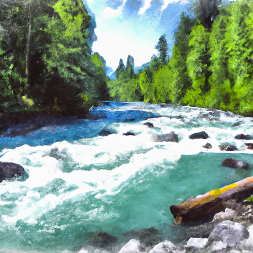
The ideal streamflow range for this section of the river is between 800-2000 cfs. Lower than 800 cfs and the river becomes too bony and challenging to navigate, while above 2000 cfs the rapids become too powerful and dangerous.
Some of the notable rapids and obstacles along the route include S-Turn, Double Drop, Pinball, and Corkscrew. These rapids offer a mix of technical maneuvers, large drops, and powerful hydraulics that require precision paddling and strong teamwork.
There are specific regulations in place for this area, including a permit requirement from the National Forest Service. The permit allows for a maximum of 12 people per group and is required from May 15th to September 15th. Additionally, all participants must wear a properly fitted personal flotation device (PFD) and helmets while on the river.
In summary, the Whitewater River run Confluence with Ranier Fork to Confluence with Bumping River is a challenging and exciting route that requires advanced paddling skills and experience. It is important to pay attention to the ideal streamflow range, class rating, segment mileage, specific river rapids/obstacles, and specific regulations before attempting this run.
Plan your run down to the hour
Same weather feed Snoflo's iOS app uses -- updated continuously from NOAA / yr.no. Watch the precipitation column on the meteogram; rain ahead of a run typically lifts flows 12-48 hours later depending on the basin.
Next 5 days, hour by hour
Temperature line with weather symbols on top, snow + rain accumulation as columns, humidity as a dotted line.
5-day forecast table
Every 3 hours, broken out across temperature, snow, rain, humidity, and wind. Each cell is colour-coded relative to the column min/max.
| Time | Condition | Temp (°F) | Snow (in) | Rain (in) | Humidity (%) | Wind (mps) | Wind dir |
|---|---|---|---|---|---|---|---|
| Loading detailed forecast… | |||||||
15-day temperature & precipitation
Daily temperatures, snow, and rain projected over the next two weeks -- the upstream story that drives next week's flows.
Regional streamflow levels
USGS streamgauges around Confluence With Ranier Fork To Confluence With Bumping River -- useful for spotting upstream pulses and gauging which tributary is contributing what.
| Streamgauge | Discharge | View |
|---|---|---|
| American River Near Nile | 63 cfs | → |
| Greenwater River At Greenwater | 49 cfs | → |
| Cedar River Below Bear Creek Near Cedar Falls | 24 cfs | → |
| Yakima River At Umtanum | 3,660 cfs | → |
| Cedar River Near Cedar Falls | 39 cfs | → |
| White River Below Clearwater River Nr Buckley | 2,550 cfs | → |
Plan a longer trip
The closest boat launches, other paddle runs, and campgrounds so a day on the water can grow into a full weekend.
Other river runs
- Headwaters At American Lake To Confluence With Ranier Fork
- Mt. Baker-Snoqualmie Nf/Mt. Ranier Np Boundary At North Section Line Of Sec 3, T17 N, R10e To Confluence With Huckleberry Creek
- Confluence With Chinook Creek To Southern Boundary Of Mount Rainier National Park
- Headwaters On The Southeast Flank Of Mount Rainier At An Elevation Of 5500 Ft To Confluence With Chinook Creek
- Private Land Boundary To Head Of Lake Cle Elum Reservoir
Whitewater safety
- Check the flow before you run
- Use the linked-gauge card and Regional Flow panel above. Class ratings change with flow -- a Class III at low water can become Class IV+ at high water.
- Know your skill ceiling
- Pick runs comfortably below your ceiling. Cold-water and big-water runs raise the consequences of any mistake.
- Wear the right gear
- Helmet, PFD, drysuit / wetsuit when water is below 60°F. Throw bag, knife, and whistle on your person, not in the boat.
- Scout, set safety, and run with a team
- Scout new rapids on foot, set safety with throw bags above the consequence pool, and run with at least one other competent paddler.
- Respect the river
- Strainers, undercuts, low-head dams, and wood can kill at any class rating. When in doubt, portage.
Set push alerts in the Snoflo app
Save Confluence With Ranier Fork To Confluence With Bumping River as a favorite, set a discharge threshold (e.g. "alert me when flow hits 600 cfs"), and the iOS app pushes the moment the linked gauge crosses.
About Confluence With Ranier Fork To Confluence With Bumping River
What's the optimal flow for Confluence With Ranier Fork To Confluence With Bumping River?
The optimal flow depends on the section and the craft. Check the Run Details panel for the linked gauge and current status.
How fresh is the cfs reading on this page?
The linked USGS streamgauge reports continuously (every 15 minutes); Snoflo refreshes throughout the day. Hover the streamflow sparkline to read individual datapoints.
What's the whitewater class?
See the Run Details panel for the class rating Snoflo tracks for this run. Class ratings change with flow -- a Class III at low water can become Class IV in high water.
Where do I put in / take out?
Tap Directions in the hero above to open driving directions to the put-in. For shuttle planning, check the Nearby Boat Launches panel and the river run operator's site.
Can I get alerts when flows hit the optimal range?
Yes -- alerts are managed in the Snoflo iOS app. Favorite this run, set a discharge threshold, and you'll get a push the moment the gauge crosses.
Other runs near here
Snoflo-tracked paddle runs within driving distance of Confluence With Ranier Fork To Confluence With Bumping River.