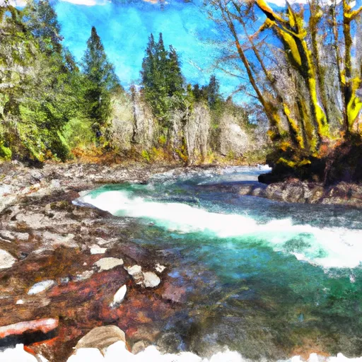
Junction Of Muddy And Clear Forks Cowlitz To Gifford Pinchot Nf Boundary River Run
Community Reviews
Been here? Share the conditions.
Reviews, ratings & photos are added in the free Snoflo iOS app — rate a spot, tag the conditions, and your visit is verified by location. Add or manage your reviews from the app.
Junction Of Muddy And Clear Forks Cowlitz To Gifford Pinchot Nf Boundary
The run starts with a series of small rapids that build up to the first major obstacle, a class IV rapid known as “Mighty Mouse.” This rapid can be bypassed by portaging on the left or running the easier Class III-IV option on the right. The next major obstacle is “Boulder Drop,” a Class IV rapid with a tight left-hand turn and a large boulder in the middle of the channel. This rapid requires precise maneuvering and a strong paddle stroke.
After Boulder Drop, the river mellows out to Class III rapids for the remainder of the run. Kayakers will encounter several challenging rapids, including “Labor Day,” “Pinball,” and “The Slot.” There are no specific regulations to this area, but it is important to respect the environment and practice Leave No Trace principles while enjoying this beautiful wilderness.
Overall, the Whitewater River run at the junction of Muddy and Clear Forks is a must-do for any avid kayaker looking for a challenging and rewarding adventure in the Pacific Northwest.
Plan your run down to the hour
Same weather feed Snoflo's iOS app uses -- updated continuously from NOAA / yr.no. Watch the precipitation column on the meteogram; rain ahead of a run typically lifts flows 12-48 hours later depending on the basin.
Next 5 days, hour by hour
Temperature line with weather symbols on top, snow + rain accumulation as columns, humidity as a dotted line.
5-day forecast table
Every 3 hours, broken out across temperature, snow, rain, humidity, and wind. Each cell is colour-coded relative to the column min/max.
| Time | Condition | Temp (°F) | Snow (in) | Rain (in) | Humidity (%) | Wind (mps) | Wind dir |
|---|---|---|---|---|---|---|---|
| Loading detailed forecast… | |||||||
15-day temperature & precipitation
Daily temperatures, snow, and rain projected over the next two weeks -- the upstream story that drives next week's flows.
Regional streamflow levels
USGS streamgauges around Junction Of Muddy And Clear Forks Cowlitz To Gifford Pinchot Nf Boundary -- useful for spotting upstream pulses and gauging which tributary is contributing what.
| Streamgauge | Discharge | View |
|---|---|---|
| Cowlitz River At Packwood | 648 cfs | → |
| Cispus River Ab Yellowjacket Creek Near Randle | 460 cfs | → |
| Cowlitz River At Randle | 1,000 cfs | → |
| Nisqually River Near National | 763 cfs | → |
| Mineral Creek Near Mineral | 32 cfs | → |
| Puyallup River Near Electron | 711 cfs | → |
Plan a longer trip
The closest boat launches, other paddle runs, and campgrounds so a day on the water can grow into a full weekend.
Boat launches
Other river runs
- Tatoosh Wilderness Boundary To Confluence With Clear Fork Cowlitz River
- Gifford Pinchot Nf Boundary To Tatoosh Wilderness Boundary
- Goat Rocks Wilderness Boundary To Confluence With Muddy Fork Cowlitz River
- Mt. Ranier Np/Gifford Pinchot Nf Boundary To Confluence With Clear Fork Cowlitz River
- Begins 1/4 Mile South Of Box Canyon To Southern Boundary Of Mount Rainier National Park
Campgrounds
- Campground: Coho Group Camp
- Campground: La Wis Wis
- Butter Creek Site
- Dispersed Camping
- Ohanapecosh - Mount Rainier National Park
- Ohanapecosh
Parks
Whitewater safety
- Check the flow before you run
- Use the linked-gauge card and Regional Flow panel above. Class ratings change with flow -- a Class III at low water can become Class IV+ at high water.
- Know your skill ceiling
- Pick runs comfortably below your ceiling. Cold-water and big-water runs raise the consequences of any mistake.
- Wear the right gear
- Helmet, PFD, drysuit / wetsuit when water is below 60°F. Throw bag, knife, and whistle on your person, not in the boat.
- Scout, set safety, and run with a team
- Scout new rapids on foot, set safety with throw bags above the consequence pool, and run with at least one other competent paddler.
- Respect the river
- Strainers, undercuts, low-head dams, and wood can kill at any class rating. When in doubt, portage.
Set push alerts in the Snoflo app
Save Junction Of Muddy And Clear Forks Cowlitz To Gifford Pinchot Nf Boundary as a favorite, set a discharge threshold (e.g. "alert me when flow hits 600 cfs"), and the iOS app pushes the moment the linked gauge crosses.
About Junction Of Muddy And Clear Forks Cowlitz To Gifford Pinchot Nf Boundary
What's the optimal flow for Junction Of Muddy And Clear Forks Cowlitz To Gifford Pinchot Nf Boundary?
The optimal flow depends on the section and the craft. Check the Run Details panel for the linked gauge and current status.
How fresh is the cfs reading on this page?
The linked USGS streamgauge reports continuously (every 15 minutes); Snoflo refreshes throughout the day. Hover the streamflow sparkline to read individual datapoints.
What's the whitewater class?
See the Run Details panel for the class rating Snoflo tracks for this run. Class ratings change with flow -- a Class III at low water can become Class IV in high water.
Where do I put in / take out?
Tap Directions in the hero above to open driving directions to the put-in. For shuttle planning, check the Nearby Boat Launches panel and the river run operator's site.
Can I get alerts when flows hit the optimal range?
Yes -- alerts are managed in the Snoflo iOS app. Favorite this run, set a discharge threshold, and you'll get a push the moment the gauge crosses.
Other runs near here
Snoflo-tracked paddle runs within driving distance of Junction Of Muddy And Clear Forks Cowlitz To Gifford Pinchot Nf Boundary.