Mt. Adams Wilderness Boundary To Gifford Pinchot Nf Boundary River Run
Community Reviews
Been here? Share the conditions.
Reviews, ratings & photos are added in the free Snoflo iOS app — rate a spot, tag the conditions, and your visit is verified by location. Add or manage your reviews from the app.
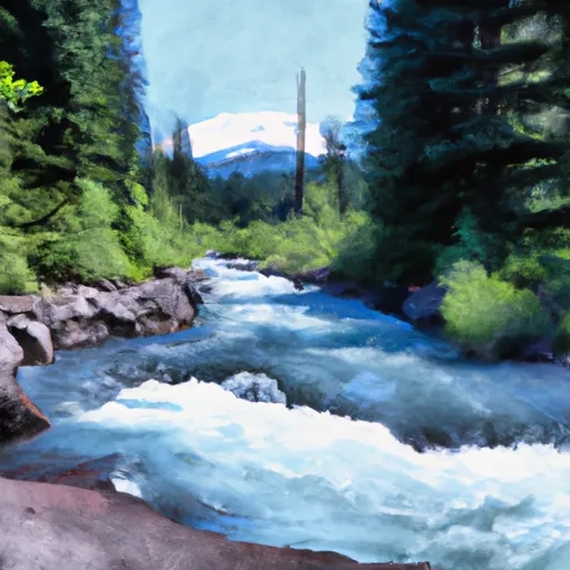
Mt. Adams Wilderness Boundary To Gifford Pinchot Nf Boundary
The segment mileage for this run is approximately 12 miles, with the river flowing through a remote and rugged wilderness area. Some of the specific rapids and obstacles that paddlers may encounter on this run include Boulder Sluice, Devil's Kitchen, and the Narrows.
There are specific regulations that paddlers must follow when navigating this river, including obtaining a permit from the US Forest Service and following Leave No Trace principles. Additionally, motorized watercraft are not allowed on this section of the river.
Plan your run down to the hour
Same weather feed Snoflo's iOS app uses -- updated continuously from NOAA / yr.no. Watch the precipitation column on the meteogram; rain ahead of a run typically lifts flows 12-48 hours later depending on the basin.
Next 5 days, hour by hour
Temperature line with weather symbols on top, snow + rain accumulation as columns, humidity as a dotted line.
5-day forecast table
Every 3 hours, broken out across temperature, snow, rain, humidity, and wind. Each cell is colour-coded relative to the column min/max.
| Time | Condition | Temp (°F) | Snow (in) | Rain (in) | Humidity (%) | Wind (mps) | Wind dir |
|---|---|---|---|---|---|---|---|
| Loading detailed forecast… | |||||||
15-day temperature & precipitation
Daily temperatures, snow, and rain projected over the next two weeks -- the upstream story that drives next week's flows.
Regional streamflow levels
USGS streamgauges around Mt. Adams Wilderness Boundary To Gifford Pinchot Nf Boundary -- useful for spotting upstream pulses and gauging which tributary is contributing what.
| Streamgauge | Discharge | View |
|---|---|---|
| Muddy Creek Below Clear Creek Near Cougar | 134 cfs | → |
| Lewis River Above Muddy River Near Cougar | 240 cfs | → |
| Speelyai Creek Near Cougar | 4 cfs | → |
| Canyon Creek Near Amboy | 31 cfs | → |
| Cispus River Ab Yellowjacket Creek Near Randle | 368 cfs | → |
| Cowlitz River Near Kosmos | 1,050 cfs | → |
Plan a longer trip
The closest boat launches, other paddle runs, and campgrounds so a day on the water can grow into a full weekend.
Boat launches
- Swift Forest Camp
- Boating Site: Mosquito Lakes
- Beaver Bay Recreation Area
- Cougar Camp And Park
- Goose Lake Campground
- Forest Road 81 Cowlitz County
Other river runs
- Confluence With Smith Creek To Confluence With Lewis River
- Gifford Pinchot Nf Boundary To Maximum Pool Of Swift Reservoir In Nw1/4 Of Sec 35, T7n, R6e
- Middle Of Sec 19, T8n, R7e To Confluence With Muddy River In Se1/4 Of Sec 1, T7n, R6e
- Trail 80 Crossing In Nw1/4 Of Sec 28, T9n, R5e To Middle Of Sec 19 T8n, R7e
- (Smith Creek Segment) Headwaters In Se 1/4 Of Sec 3, T8n, R5e To Confluence With Muddy River
Campgrounds
- Swift Forest Camp
- Campground: Lower Falls
- Lower Falls
- Campground: Paradise Creek
- Paradise Creek
- Berry Camp
Parks
Whitewater safety
- Check the flow before you run
- Use the linked-gauge card and Regional Flow panel above. Class ratings change with flow -- a Class III at low water can become Class IV+ at high water.
- Know your skill ceiling
- Pick runs comfortably below your ceiling. Cold-water and big-water runs raise the consequences of any mistake.
- Wear the right gear
- Helmet, PFD, drysuit / wetsuit when water is below 60°F. Throw bag, knife, and whistle on your person, not in the boat.
- Scout, set safety, and run with a team
- Scout new rapids on foot, set safety with throw bags above the consequence pool, and run with at least one other competent paddler.
- Respect the river
- Strainers, undercuts, low-head dams, and wood can kill at any class rating. When in doubt, portage.
Set push alerts in the Snoflo app
Save Mt. Adams Wilderness Boundary To Gifford Pinchot Nf Boundary as a favorite, set a discharge threshold (e.g. "alert me when flow hits 600 cfs"), and the iOS app pushes the moment the linked gauge crosses.
About Mt. Adams Wilderness Boundary To Gifford Pinchot Nf Boundary
What's the optimal flow for Mt. Adams Wilderness Boundary To Gifford Pinchot Nf Boundary?
The optimal flow depends on the section and the craft. Check the Run Details panel for the linked gauge and current status.
How fresh is the cfs reading on this page?
The linked USGS streamgauge reports continuously (every 15 minutes); Snoflo refreshes throughout the day. Hover the streamflow sparkline to read individual datapoints.
What's the whitewater class?
See the Run Details panel for the class rating Snoflo tracks for this run. Class ratings change with flow -- a Class III at low water can become Class IV in high water.
Where do I put in / take out?
Tap Directions in the hero above to open driving directions to the put-in. For shuttle planning, check the Nearby Boat Launches panel and the river run operator's site.
Can I get alerts when flows hit the optimal range?
Yes -- alerts are managed in the Snoflo iOS app. Favorite this run, set a discharge threshold, and you'll get a push the moment the gauge crosses.
Other runs near here
Snoflo-tracked paddle runs within driving distance of Mt. Adams Wilderness Boundary To Gifford Pinchot Nf Boundary.