Confluence Of East And West Forks Of Foss River To Confluence With Tye River River Run
Community Reviews
Been here? Share the conditions.
Reviews, ratings & photos are added in the free Snoflo iOS app — rate a spot, tag the conditions, and your visit is verified by location. Add or manage your reviews from the app.
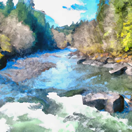
Confluence Of East And West Forks Of Foss River To Confluence With Tye River
The segment covers a distance of approximately 5.5 miles and features a number of notable rapids and obstacles, including the "Zig Zag" and "Toilet Bowl" rapids. These rapids are characterized by large waves, steep drops, and strong currents.
In terms of regulations, boaters are required to follow all state and federal laws, including wearing a personal flotation device at all times and carrying proper safety equipment. The area is also subject to seasonal closures and restrictions, so it is important to check with local authorities before planning a trip.
Overall, the Whitewater River Run from the confluence of East and West Forks of Foss River to confluence with Tye River is a challenging and rewarding experience for those with the necessary skills and equipment. It is important to approach this segment with caution and respect for its natural beauty and potential dangers.
Plan your run down to the hour
Same weather feed Snoflo's iOS app uses -- updated continuously from NOAA / yr.no. Watch the precipitation column on the meteogram; rain ahead of a run typically lifts flows 12-48 hours later depending on the basin.
Next 5 days, hour by hour
Temperature line with weather symbols on top, snow + rain accumulation as columns, humidity as a dotted line.
5-day forecast table
Every 3 hours, broken out across temperature, snow, rain, humidity, and wind. Each cell is colour-coded relative to the column min/max.
| Time | Condition | Temp (°F) | Snow (in) | Rain (in) | Humidity (%) | Wind (mps) | Wind dir |
|---|---|---|---|---|---|---|---|
| Loading detailed forecast… | |||||||
15-day temperature & precipitation
Daily temperatures, snow, and rain projected over the next two weeks -- the upstream story that drives next week's flows.
Regional streamflow levels
USGS streamgauges around Confluence Of East And West Forks Of Foss River To Confluence With Tye River -- useful for spotting upstream pulses and gauging which tributary is contributing what.
| Streamgauge | Discharge | View |
|---|---|---|
| South Fork Tolt River Near Index | 3 cfs | → |
| South Fork Tolt River Near Carnation | 65 cfs | → |
| Skykomish River Near Gold Bar | 512 cfs | → |
| Nf Snoqualmie River Near Snoqualmie Falls | 47 cfs | → |
| Middle Fork Snoqualmie River Near Tanner | 147 cfs | → |
| Sf Tolt River Bl Regulating Basin Nr Carnation | 70 cfs | → |
Plan a longer trip
The closest boat launches, other paddle runs, and campgrounds so a day on the water can grow into a full weekend.
Other river runs
- Headwaters In Se 1/4 Of Sec 14, T26n, R13e To Confluence With Foss River
- Alpine Lakes Wilderness Boundary To Confluence With West Fork Foss River
- Alpine Lakes Wilderness Boundary To Confluence With East Fork Foss River
- Confluence Of East And West Forks Of Miller River To Confluence With South Fork Skykomish River
- Headwaters In Sw 1/4 Of Sec 11, T24n, R13e To Alpine Lakes Wilderness Boundary
Whitewater safety
- Check the flow before you run
- Use the linked-gauge card and Regional Flow panel above. Class ratings change with flow -- a Class III at low water can become Class IV+ at high water.
- Know your skill ceiling
- Pick runs comfortably below your ceiling. Cold-water and big-water runs raise the consequences of any mistake.
- Wear the right gear
- Helmet, PFD, drysuit / wetsuit when water is below 60°F. Throw bag, knife, and whistle on your person, not in the boat.
- Scout, set safety, and run with a team
- Scout new rapids on foot, set safety with throw bags above the consequence pool, and run with at least one other competent paddler.
- Respect the river
- Strainers, undercuts, low-head dams, and wood can kill at any class rating. When in doubt, portage.
Set push alerts in the Snoflo app
Save Confluence Of East And West Forks Of Foss River To Confluence With Tye River as a favorite, set a discharge threshold (e.g. "alert me when flow hits 600 cfs"), and the iOS app pushes the moment the linked gauge crosses.
About Confluence Of East And West Forks Of Foss River To Confluence With Tye River
What's the optimal flow for Confluence Of East And West Forks Of Foss River To Confluence With Tye River?
The optimal flow depends on the section and the craft. Check the Run Details panel for the linked gauge and current status.
How fresh is the cfs reading on this page?
The linked USGS streamgauge reports continuously (every 15 minutes); Snoflo refreshes throughout the day. Hover the streamflow sparkline to read individual datapoints.
What's the whitewater class?
See the Run Details panel for the class rating Snoflo tracks for this run. Class ratings change with flow -- a Class III at low water can become Class IV in high water.
Where do I put in / take out?
Tap Directions in the hero above to open driving directions to the put-in. For shuttle planning, check the Nearby Boat Launches panel and the river run operator's site.
Can I get alerts when flows hit the optimal range?
Yes -- alerts are managed in the Snoflo iOS app. Favorite this run, set a discharge threshold, and you'll get a push the moment the gauge crosses.
Other runs near here
Snoflo-tracked paddle runs within driving distance of Confluence Of East And West Forks Of Foss River To Confluence With Tye River.