Confluence With Troublesome Creek To Confluence With South Fork Skykomish River River Run
Community Reviews
Been here? Share the conditions.
Reviews, ratings & photos are added in the free Snoflo iOS app — rate a spot, tag the conditions, and your visit is verified by location. Add or manage your reviews from the app.
Confluence With Troublesome Creek To Confluence With South Fork Skykomish River
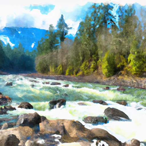
The segment mileage of this section of the river is approximately 12 miles, and it features several specific river rapids and obstacles, including Boulder Drop, Railroad Rapids, and Golf Course Drop. These rapids are known for their technical difficulty and require skilled maneuvering.
There are specific regulations in place for this area, and all visitors must obtain a valid permit to use the river. Additionally, all visitors must wear a personal flotation device (PFD) at all times while on the river.
Overall, the Whitewater River Run from Confluence with Troublesome Creek to Confluence with South Fork Skykomish River is a challenging and thrilling destination for experienced whitewater rafters. It is important to adhere to all regulations and safety precautions while enjoying this section of the river.
Plan your run down to the hour
Same weather feed Snoflo's iOS app uses -- updated continuously from NOAA / yr.no. Watch the precipitation column on the meteogram; rain ahead of a run typically lifts flows 12-48 hours later depending on the basin.
Next 5 days, hour by hour
Temperature line with weather symbols on top, snow + rain accumulation as columns, humidity as a dotted line.
5-day forecast table
Every 3 hours, broken out across temperature, snow, rain, humidity, and wind. Each cell is colour-coded relative to the column min/max.
| Time | Condition | Temp (°F) | Snow (in) | Rain (in) | Humidity (%) | Wind (mps) | Wind dir |
|---|---|---|---|---|---|---|---|
| Loading detailed forecast… | |||||||
15-day temperature & precipitation
Daily temperatures, snow, and rain projected over the next two weeks -- the upstream story that drives next week's flows.
Regional streamflow levels
USGS streamgauges around Confluence With Troublesome Creek To Confluence With South Fork Skykomish River -- useful for spotting upstream pulses and gauging which tributary is contributing what.
| Streamgauge | Discharge | View |
|---|---|---|
| Skykomish River Near Gold Bar | 738 cfs | → |
| South Fork Tolt River Near Index | 5 cfs | → |
| South Fork Sultan River Near Sultan | 13 cfs | → |
| South Fork Tolt River Near Carnation | 67 cfs | → |
| North Fork Tolt River Near Carnation | 68 cfs | → |
| Sf Tolt River Bl Regulating Basin Nr Carnation | 73 cfs | → |
Plan a longer trip
The closest boat launches, other paddle runs, and campgrounds so a day on the water can grow into a full weekend.
Boat launches
- South Shore Road Snohomish County
- Stevens Pass Highway Sultan
- King County
- Lake Margaret
- Upper Tolt
- Ben Howard Road 21101-21283, Monroe
Other river runs
- Confluence Of Tye And Foss Rivers To Gold Bar
- End Of Usfs Road 63 To Confluence With Troublesome Creek
- Usfs Road 63 To Confluence With North Fork Skykomish River
- Headwaters At Outlet Of Blanca Lake To Usfs Road 63
- Confluence Of East And West Forks Of Miller River To Confluence With South Fork Skykomish River
Campgrounds
- Gold Bar Nature Trails
- Wallace Lake Backcountry Camping
- Jay Lake Backcountry Camping
- Money Creek
- Cascades Rv Park
- Money Creek Campground
Whitewater safety
- Check the flow before you run
- Use the linked-gauge card and Regional Flow panel above. Class ratings change with flow -- a Class III at low water can become Class IV+ at high water.
- Know your skill ceiling
- Pick runs comfortably below your ceiling. Cold-water and big-water runs raise the consequences of any mistake.
- Wear the right gear
- Helmet, PFD, drysuit / wetsuit when water is below 60°F. Throw bag, knife, and whistle on your person, not in the boat.
- Scout, set safety, and run with a team
- Scout new rapids on foot, set safety with throw bags above the consequence pool, and run with at least one other competent paddler.
- Respect the river
- Strainers, undercuts, low-head dams, and wood can kill at any class rating. When in doubt, portage.
Set push alerts in the Snoflo app
Save Confluence With Troublesome Creek To Confluence With South Fork Skykomish River as a favorite, set a discharge threshold (e.g. "alert me when flow hits 600 cfs"), and the iOS app pushes the moment the linked gauge crosses.
About Confluence With Troublesome Creek To Confluence With South Fork Skykomish River
What's the optimal flow for Confluence With Troublesome Creek To Confluence With South Fork Skykomish River?
The optimal flow depends on the section and the craft. Check the Run Details panel for the linked gauge and current status.
How fresh is the cfs reading on this page?
The linked USGS streamgauge reports continuously (every 15 minutes); Snoflo refreshes throughout the day. Hover the streamflow sparkline to read individual datapoints.
What's the whitewater class?
See the Run Details panel for the class rating Snoflo tracks for this run. Class ratings change with flow -- a Class III at low water can become Class IV in high water.
Where do I put in / take out?
Tap Directions in the hero above to open driving directions to the put-in. For shuttle planning, check the Nearby Boat Launches panel and the river run operator's site.
Can I get alerts when flows hit the optimal range?
Yes -- alerts are managed in the Snoflo iOS app. Favorite this run, set a discharge threshold, and you'll get a push the moment the gauge crosses.
Other runs near here
Snoflo-tracked paddle runs within driving distance of Confluence With Troublesome Creek To Confluence With South Fork Skykomish River.