Similkameen River Segment 2 River Run
Community Reviews
Been here? Share the conditions.
Reviews, ratings & photos are added in the free Snoflo iOS app — rate a spot, tag the conditions, and your visit is verified by location. Add or manage your reviews from the app.
Similkameen River Segment 2
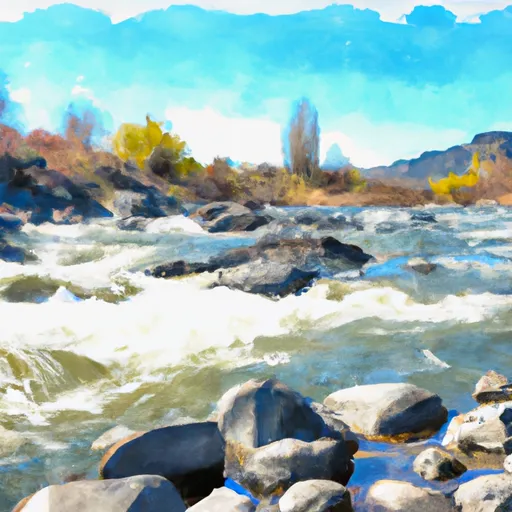
The segment mileage for the Similkameen River Segment 2 is approximately 8 miles, with several notable rapids and obstacles along the way. One of the most challenging rapids on this segment is "Frog Pond," which features a steep drop and strong currents. Other notable obstacles include "Goat Creek Falls" and "Devil's Toilet Bowl."
There are specific regulations in place for the Similkameen River Segment 2, including the requirement for a valid Washington State Parks Discover Pass to access the launch site. Additionally, all boaters are required to wear personal flotation devices (PFDs) and carry a whistle and throw rope. It is also prohibited to bring glass containers or alcoholic beverages on the river.
Overall, the Similkameen River Segment 2 offers a thrilling whitewater experience for experienced boaters with its challenging rapids and stunning scenery. However, it is important to adhere to all regulations and safety precautions to ensure a safe and enjoyable trip.
Plan your run down to the hour
Same weather feed Snoflo's iOS app uses -- updated continuously from NOAA / yr.no. Watch the precipitation column on the meteogram; rain ahead of a run typically lifts flows 12-48 hours later depending on the basin.
Next 5 days, hour by hour
Temperature line with weather symbols on top, snow + rain accumulation as columns, humidity as a dotted line.
5-day forecast table
Every 3 hours, broken out across temperature, snow, rain, humidity, and wind. Each cell is colour-coded relative to the column min/max.
| Time | Condition | Temp (°F) | Snow (in) | Rain (in) | Humidity (%) | Wind (mps) | Wind dir |
|---|---|---|---|---|---|---|---|
| Loading detailed forecast… | |||||||
15-day temperature & precipitation
Daily temperatures, snow, and rain projected over the next two weeks -- the upstream story that drives next week's flows.
Regional streamflow levels
USGS streamgauges around Similkameen River Segment 2 -- useful for spotting upstream pulses and gauging which tributary is contributing what.
| Streamgauge | Discharge | View |
|---|---|---|
| Okanogan River At Oroville | 271 cfs | → |
| Similkameen River Near Nighthawk | 392 cfs | → |
| Okanogan River Near Tonasket | 597 cfs | → |
| Kettle River Near Ferry | 122 cfs | → |
| Andrews Creek Near Mazama | 5 cfs | → |
| Omak Creek Near Omak | 0 cfs | → |
Plan a longer trip
The closest boat launches, other paddle runs, and campgrounds so a day on the water can grow into a full weekend.
Boat launches
- Osoyoos Lake State Park
- Deep Bay Road 98, Oroville
- Veranda Beach Resort
- Wannacut Lake
- Palmer Lake Campground And Picnic Area
- Loomis-Oroville Road 1667, Loomis
Other river runs
- Similkameen River Segment 1
- Confluence With Tungsten Creek To Pasayten Wilderness Boundary
- Salmon Creek
- Pasayten Wilderness Boundary To Okanogan Nf Boundary
- Lake Chelan-Sawtooth Wilderness Boundary To Okanogan Nf Boundary
Whitewater safety
- Check the flow before you run
- Use the linked-gauge card and Regional Flow panel above. Class ratings change with flow -- a Class III at low water can become Class IV+ at high water.
- Know your skill ceiling
- Pick runs comfortably below your ceiling. Cold-water and big-water runs raise the consequences of any mistake.
- Wear the right gear
- Helmet, PFD, drysuit / wetsuit when water is below 60°F. Throw bag, knife, and whistle on your person, not in the boat.
- Scout, set safety, and run with a team
- Scout new rapids on foot, set safety with throw bags above the consequence pool, and run with at least one other competent paddler.
- Respect the river
- Strainers, undercuts, low-head dams, and wood can kill at any class rating. When in doubt, portage.
Set push alerts in the Snoflo app
Save Similkameen River Segment 2 as a favorite, set a discharge threshold (e.g. "alert me when flow hits 600 cfs"), and the iOS app pushes the moment the linked gauge crosses.
About Similkameen River Segment 2
What's the optimal flow for Similkameen River Segment 2?
The optimal flow depends on the section and the craft. Check the Run Details panel for the linked gauge and current status.
How fresh is the cfs reading on this page?
The linked USGS streamgauge reports continuously (every 15 minutes); Snoflo refreshes throughout the day. Hover the streamflow sparkline to read individual datapoints.
What's the whitewater class?
See the Run Details panel for the class rating Snoflo tracks for this run. Class ratings change with flow -- a Class III at low water can become Class IV in high water.
Where do I put in / take out?
Tap Directions in the hero above to open driving directions to the put-in. For shuttle planning, check the Nearby Boat Launches panel and the river run operator's site.
Can I get alerts when flows hit the optimal range?
Yes -- alerts are managed in the Snoflo iOS app. Favorite this run, set a discharge threshold, and you'll get a push the moment the gauge crosses.
Other runs near here
Snoflo-tracked paddle runs within driving distance of Similkameen River Segment 2.