Southwest Bonaparte Lake Road, Tonasket Boat Launch
Community Reviews
Been here? Share the conditions.
Reviews, ratings & photos are added in the free Snoflo iOS app — rate a spot, tag the conditions, and your visit is verified by location. Add or manage your reviews from the app.
Southwest Bonaparte Lake Road, Tonasket
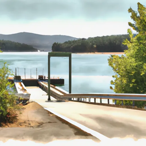
According to the Washington State Department of Fish and Wildlife, the boat ramp named Southwest Bonaparte Lake Road is located on the southwest shore of Bonaparte Lake, near the town of Tonasket. This boat ramp is open to the public and provides access to the lake for various types of watercraft, including motorboats, rowboats, canoes, and kayaks.
The boat ramp is described as a "primitive" facility, meaning that it does not have any amenities such as restrooms or parking areas. However, it is maintained by the state and is accessible to most types of vehicles, including trailers.
In terms of width, the boat ramp appears to be narrow, with room for only one vehicle and boat at a time. However, it is noted that the lake is relatively small and does not receive heavy boating traffic, so the narrowness of the ramp is not likely to be a significant issue.
Based on the available information, it appears that the Southwest Bonaparte Lake Road boat ramp is a basic facility that provides access to a small lake in north-central Washington. While it may not be the most luxurious boat ramp in the state, it serves its purpose by allowing visitors to enjoy the natural beauty of Bonaparte Lake and its surroundings.
Plan your launch down to the hour
Same weather feed Snoflo's iOS app uses -- updated continuously from NOAA / yr.no.
Next 5 days, hour by hour
Temperature line with weather symbols on top, snow + rain accumulation as columns, humidity as a dotted line.
5-day forecast table
Every 3 hours, broken out across temperature, snow, rain, humidity, and wind.
| Time | Condition | Temp (°F) | Snow (in) | Rain (in) | Humidity (%) | Wind (mps) | Wind dir |
|---|---|---|---|---|---|---|---|
| Loading detailed forecast… | |||||||
15-day temperature & precipitation
Daily temperatures, snow, and rain projected over the next two weeks.
Area streamflow levels
USGS streamgauges around Southwest Bonaparte Lake Road, Tonasket -- the same readings that determine whether your launch is safe and your boat is the right craft.
| Streamgauge | Discharge | View |
|---|---|---|
| Kettle River Near Ferry | 163 cfs | → |
| Okanogan River At Oroville | 168 cfs | → |
| Okanogan River Near Tonasket | 597 cfs | → |
| Similkameen River Near Nighthawk | 491 cfs | → |
Plan a longer trip
The closest paddle runs, fishing spots, and other boat launches so you can extend a day on the water.
River runs
Boating safety & etiquette
- Check the conditions before you launch
- Use the streamflow numbers, weather, and wind forecast on this page. High-cfs whitewater requires whitewater-specific craft and skill.
- Wear your life jacket
- Statistically the single biggest survival factor in a boating incident. State law often requires one per passenger.
- File a float plan
- Tell someone on shore your put-in, take-out, and expected return time. Especially for multi-day or remote trips.
- Yield at the ramp
- Prep gear in the parking lot, not on the ramp. Launch and clear quickly so others can use the lane.
- Clean, drain, dry
- Inspect, clean, drain and dry your boat between waters to prevent the spread of aquatic invasive species.
Set push alerts in the Snoflo app
Save Southwest Bonaparte Lake Road, Tonasket as a favorite, set a discharge threshold or a wind/precipitation alert, and the iOS app will push the moment conditions cross.
About Southwest Bonaparte Lake Road, Tonasket
Can I launch a motorboat here?
Most Snoflo-tracked launches support motorboats; check the operator for any horsepower restrictions, paddle-only zones, or seasonal closures.
How fresh is the streamflow data?
USGS streamgauges report continuously (every 15 minutes); the table on this page pulls the latest reading at page load.
Is there a fee?
Many federal and state boat launches charge a day-use fee. Check the operator's site before driving out.
What boat is right for these conditions?
Use the nearby streamflow numbers and river-run panel on this page to gauge current conditions. Wider, slower water is friendly for casual paddling and powerboats; high-cfs whitewater requires whitewater-specific craft and skill.
Can I get alerts when conditions change?
Yes -- alerts are managed in the Snoflo iOS app. Favorite this launch, set a threshold (discharge, wind), and you'll get a push the moment it crosses.
Other launches near here
Snoflo-tracked boat launches within driving distance of Southwest Bonaparte Lake Road, Tonasket.