,5 Mile Above Us 33 To Waterfall Run River Run
Community Reviews
Been here? Share the conditions.
Reviews, ratings & photos are added in the free Snoflo iOS app — rate a spot, tag the conditions, and your visit is verified by location. Add or manage your reviews from the app.
,5 Mile Above Us 33 To Waterfall Run
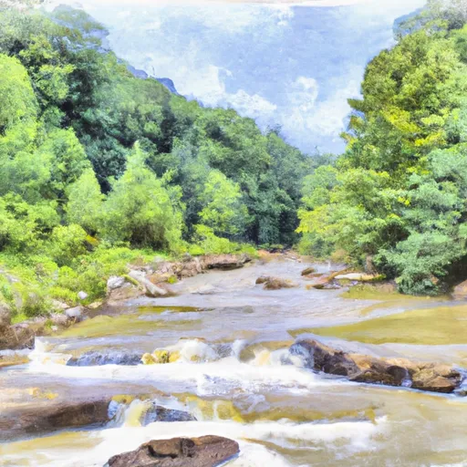
The class rating for this run is Class III-IV, which means it has intermediate to advanced rapids and waves that require experienced paddling skills. The segment covers a distance of approximately 10 miles and includes various rapids such as "Big Nasty," "Staircase," and "Jump Rock." These rapids offer exciting challenges for seasoned rafters and are considered the highlights of the run.
One of the most notable obstacles on this river is the "Big Nasty" rapid, which is a long and technical rapid with multiple drops and boulders. It requires precise maneuvering and teamwork to navigate successfully. Another obstacle is "Jump Rock," a popular spot for cliff jumping. However, jumping from this rock is not allowed due to safety concerns.
There are specific regulations that apply to the Whitewater River Run, 5 Mile Above Us 33 To Waterfall Run. All rafters must wear personal flotation devices (PFDs) at all times while on the river, and helmets are strongly recommended. Additionally, the minimum age for rafters is 12 years old, and anyone under the age of 18 must be accompanied by an adult.
In conclusion, the Whitewater River Run, 5 Mile Above Us 33 To Waterfall Run in West Virginia is a thrilling and challenging destination for white water rafting. With its Class III-IV rapids, ideal streamflow range, and specific regulations, it provides a safe yet exhilarating experience for experienced paddlers.
Plan your run down to the hour
Same weather feed Snoflo's iOS app uses -- updated continuously from NOAA / yr.no. Watch the precipitation column on the meteogram; rain ahead of a run typically lifts flows 12-48 hours later depending on the basin.
Next 5 days, hour by hour
Temperature line with weather symbols on top, snow + rain accumulation as columns, humidity as a dotted line.
5-day forecast table
Every 3 hours, broken out across temperature, snow, rain, humidity, and wind. Each cell is colour-coded relative to the column min/max.
| Time | Condition | Temp (°F) | Snow (in) | Rain (in) | Humidity (%) | Wind (mps) | Wind dir |
|---|---|---|---|---|---|---|---|
| Loading detailed forecast… | |||||||
15-day temperature & precipitation
Daily temperatures, snow, and rain projected over the next two weeks -- the upstream story that drives next week's flows.
Regional streamflow levels
USGS streamgauges around ,5 Mile Above Us 33 To Waterfall Run -- useful for spotting upstream pulses and gauging which tributary is contributing what.
| Streamgauge | Discharge | View |
|---|---|---|
| Shavers Fork Below Bowden | 136 cfs | → |
| Dry Fork At Hendricks | 213 cfs | → |
| Cheat River Near Parsons | 643 cfs | → |
| Tygart Valley River Near Dailey | 78 cfs | → |
| Blackwater R At Davis | 68 cfs | → |
| Tygart Valley River At Belington | 217 cfs | → |
Plan a longer trip
The closest boat launches, other paddle runs, and campgrounds so a day on the water can grow into a full weekend.
Boat launches
Other river runs
- Frazier Creek To .5 Mile Above Us 33
- .5 North Of Us 33 To Shears Hollow
- .5 Mile Above Route 22 To Us 33
- Shears Hollow To Private Land
- Private Land To Dry Fork
Campgrounds
- Bear Heaven Campground
- Cooper's Campground
- Stuart Day Use Area And Campground
- Stuart Campground
- Brian's Place
- Casa Vitela
Whitewater safety
- Check the flow before you run
- Use the linked-gauge card and Regional Flow panel above. Class ratings change with flow -- a Class III at low water can become Class IV+ at high water.
- Know your skill ceiling
- Pick runs comfortably below your ceiling. Cold-water and big-water runs raise the consequences of any mistake.
- Wear the right gear
- Helmet, PFD, drysuit / wetsuit when water is below 60°F. Throw bag, knife, and whistle on your person, not in the boat.
- Scout, set safety, and run with a team
- Scout new rapids on foot, set safety with throw bags above the consequence pool, and run with at least one other competent paddler.
- Respect the river
- Strainers, undercuts, low-head dams, and wood can kill at any class rating. When in doubt, portage.
Set push alerts in the Snoflo app
Save ,5 Mile Above Us 33 To Waterfall Run as a favorite, set a discharge threshold (e.g. "alert me when flow hits 600 cfs"), and the iOS app pushes the moment the linked gauge crosses.
About ,5 Mile Above Us 33 To Waterfall Run
What's the optimal flow for ,5 Mile Above Us 33 To Waterfall Run?
The optimal flow depends on the section and the craft. Check the Run Details panel for the linked gauge and current status.
How fresh is the cfs reading on this page?
The linked USGS streamgauge reports continuously (every 15 minutes); Snoflo refreshes throughout the day. Hover the streamflow sparkline to read individual datapoints.
What's the whitewater class?
See the Run Details panel for the class rating Snoflo tracks for this run. Class ratings change with flow -- a Class III at low water can become Class IV in high water.
Where do I put in / take out?
Tap Directions in the hero above to open driving directions to the put-in. For shuttle planning, check the Nearby Boat Launches panel and the river run operator's site.
Can I get alerts when flows hit the optimal range?
Yes -- alerts are managed in the Snoflo iOS app. Favorite this run, set a discharge threshold, and you'll get a push the moment the gauge crosses.
Other runs near here
Snoflo-tracked paddle runs within driving distance of ,5 Mile Above Us 33 To Waterfall Run.