Smoke Hole Canyon Overview
Community Reviews
Been here? Share the conditions.
Reviews, ratings & photos are added in the free Snoflo iOS app — rate a spot, tag the conditions, and your visit is verified by location. Add or manage your reviews from the app.
Smoke Hole Canyon
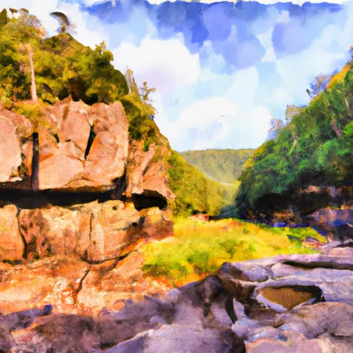
<p>About 185 million years ago, a seven-mile thick sheet of sedimentary rocks began to buckle and fold. Wind and water wore away the softer layers, wearing down the mountains, and creating a region of rolling plains. Then the plains themselves were violently uplifted and broken. The rivers that had previously rolled gently over the plains turned into raging torrents that cut deep gorges and canyons. One such gorge is the Smoke Hole, where the South Branch of the Potomac River squeezes between North Mountain and Cave Mountain. For over 20 miles the river has carved a half-mile deep canyon, with nearly vertical walls.</p><p>The misty fog that often lies along the river as it runs through the "hole" makes the name appropriate. Where the name really came from is uncertain. Some old timers call the canyon "Smoke Holes" and claim Native Americans used the caves for smoking meat. Others say it was the moonshiner's stills that gave the gorge its name. Regardless, the canyon is considered by many to be one of the most beautiful areas in West Virginia. The remote, rugged landscape provides a unique recreation experience, whether you are fishing, hunting, hiking, canoeing or camping. The roads into the area are narrow and winding: take your time and enjoy the scenery.</p>
Plan your visit down to the hour
Same weather feed Snoflo's iOS app uses -- updated continuously from NOAA / yr.no.
Next 5 days, hour by hour
Temperature line with weather symbols on top, snow + rain accumulation as columns, humidity as a dotted line.
5-day forecast table
Every 3 hours, broken out across temperature, snow, rain, humidity, and wind.
| Time | Condition | Temp (°F) | Snow (in) | Rain (in) | Humidity (%) | Wind (mps) | Wind dir |
|---|---|---|---|---|---|---|---|
| Loading detailed forecast… | |||||||
15-day temperature & precipitation
Daily temperatures, snow, and rain projected over the next two weeks.
Plan a longer trip
The closest parks, campgrounds, fishing spots, and other landmarks so a quick visit can grow into a full day.
Parks
- Wilderness Dolly Sods
- Wilderness Roaring Plains West
- Bear Rocks Preserve
- Canaan Valley National Wildlife Refuge
- Canaan Valley State Park
- Spruce Knob-Seneca Rocks National Recreation Area
Campgrounds
- Jess Judy Group Campground
- Princess Snowbird Campground
- Seneca Rocks Rv Resort
- Seneca Shadows Campground
- Camp Run Campground
- Red Creek Campground
Responsible visitation & Leave No Trace
- Know before you go
- Check the operator's site (BLM, NPS, state agency, or private owner) for access rules, permits, and seasonal closures before driving out.
- Stay on trail
- Many points of interest sit in fragile ecosystems. Stick to marked paths to protect vegetation and prevent erosion.
- Respect wildlife
- Observe from a distance, never feed wildlife, and give nesting birds and denning mammals plenty of space.
- Pack it in, pack it out
- Take all trash, food scraps, and gear back with you. Remote sites often have no trash service.
- Leave what you find
- Don't take rocks, plants, fossils, or artifacts. Federal law protects cultural and natural resources on public land.
Set push alerts in the Snoflo app
Save Smoke Hole Canyon as a favorite, set a weather threshold (precipitation, freezing temperatures), and the iOS app will push the moment conditions cross.
About Smoke Hole Canyon
What is Smoke Hole Canyon?
A point of interest in West-Virginia tracked by Snoflo -- typically a scenic landmark, named summit, monument, or viewpoint.
How fresh is the weather data?
The hourly forecast updates throughout the day from NOAA / yr.no public feeds.
When is the best time to visit?
Use the 15-day temperature & precipitation outlook on this page to pick a window with comfortable temperatures and low precipitation.
How do I get there?
Tap Directions in the hero above for Google Maps driving directions, or Open in map to center the Snoflo interactive map on the spot.
Can I get alerts when conditions change?
Yes -- alerts are managed in the Snoflo iOS app. Favorite this POI, set a threshold (temperature, precipitation), and you'll get a push the moment it crosses.
Other points of interest near here
Snoflo-tracked landmarks within driving distance of Smoke Hole Canyon.