Thorofare Creek Source To Yellowstone Np Boundary River Run
Community Reviews
Been here? Share the conditions.
Reviews, ratings & photos are added in the free Snoflo iOS app — rate a spot, tag the conditions, and your visit is verified by location. Add or manage your reviews from the app.
Thorofare Creek Source To Yellowstone Np Boundary
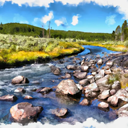
The Whitewater River Run of Thorofare Creek Source to Yellowstone Np Boundary is a popular adventure sport for rafters and kayakers looking for a challenging and scenic river run. The ideal streamflow range for this river is between 300 and 800 cubic feet per second (cfs), which is considered a moderate to high flow rate. The class rating for this river run ranges from class II to class IV, depending on the segment of the river being navigated. The total segment mileage for this river run is approximately 26 miles.
There are specific river rapids and obstacles that make this river run exciting and challenging. Some of the notable rapids include the Thorofare Rapid, the Whirlpool Rapid, and the Big Drop Rapid. The river also has several sections of technical whitewater, which requires skill and experience to navigate.
There are specific regulations for this area that must be followed by all visitors. For example, all boaters must have a Yellowstone National Park boating permit, and all boats must be inspected for invasive species before entering the river. Additionally, all visitors must follow Leave No Trace principles and pack out all trash and waste.
Plan your run down to the hour
Same weather feed Snoflo's iOS app uses -- updated continuously from NOAA / yr.no. Watch the precipitation column on the meteogram; rain ahead of a run typically lifts flows 12-48 hours later depending on the basin.
Next 5 days, hour by hour
Temperature line with weather symbols on top, snow + rain accumulation as columns, humidity as a dotted line.
5-day forecast table
Every 3 hours, broken out across temperature, snow, rain, humidity, and wind. Each cell is colour-coded relative to the column min/max.
| Time | Condition | Temp (°F) | Snow (in) | Rain (in) | Humidity (%) | Wind (mps) | Wind dir |
|---|---|---|---|---|---|---|---|
| Loading detailed forecast… | |||||||
15-day temperature & precipitation
Daily temperatures, snow, and rain projected over the next two weeks -- the upstream story that drives next week's flows.
Regional streamflow levels
USGS streamgauges around Thorofare Creek Source To Yellowstone Np Boundary -- useful for spotting upstream pulses and gauging which tributary is contributing what.
| Streamgauge | Discharge | View |
|---|---|---|
| South Fork Shoshone River Near Valley | 187 cfs | → |
| Buffalo Fork Ab Lava Creek Nr Moran Wy | 434 cfs | → |
| Pacific Creek At Moran Wy | 69 cfs | → |
| Snake River Ab Jackson Lake At Flagg Ranch Wy | 333 cfs | → |
| Snake River Nr Moran Wy | 4,990 cfs | → |
| Yellowstone River At Yellowstone Lk Outlet Ynp | 2,170 cfs | → |
Plan a longer trip
The closest boat launches, other paddle runs, and campgrounds so a day on the water can grow into a full weekend.
Whitewater safety
- Check the flow before you run
- Use the linked-gauge card and Regional Flow panel above. Class ratings change with flow -- a Class III at low water can become Class IV+ at high water.
- Know your skill ceiling
- Pick runs comfortably below your ceiling. Cold-water and big-water runs raise the consequences of any mistake.
- Wear the right gear
- Helmet, PFD, drysuit / wetsuit when water is below 60°F. Throw bag, knife, and whistle on your person, not in the boat.
- Scout, set safety, and run with a team
- Scout new rapids on foot, set safety with throw bags above the consequence pool, and run with at least one other competent paddler.
- Respect the river
- Strainers, undercuts, low-head dams, and wood can kill at any class rating. When in doubt, portage.
Set push alerts in the Snoflo app
Save Thorofare Creek Source To Yellowstone Np Boundary as a favorite, set a discharge threshold (e.g. "alert me when flow hits 600 cfs"), and the iOS app pushes the moment the linked gauge crosses.
About Thorofare Creek Source To Yellowstone Np Boundary
What's the optimal flow for Thorofare Creek Source To Yellowstone Np Boundary?
The optimal flow depends on the section and the craft. Check the Run Details panel for the linked gauge and current status.
How fresh is the cfs reading on this page?
The linked USGS streamgauge reports continuously (every 15 minutes); Snoflo refreshes throughout the day. Hover the streamflow sparkline to read individual datapoints.
What's the whitewater class?
See the Run Details panel for the class rating Snoflo tracks for this run. Class ratings change with flow -- a Class III at low water can become Class IV in high water.
Where do I put in / take out?
Tap Directions in the hero above to open driving directions to the put-in. For shuttle planning, check the Nearby Boat Launches panel and the river run operator's site.
Can I get alerts when flows hit the optimal range?
Yes -- alerts are managed in the Snoflo iOS app. Favorite this run, set a discharge threshold, and you'll get a push the moment the gauge crosses.
Other runs near here
Snoflo-tracked paddle runs within driving distance of Thorofare Creek Source To Yellowstone Np Boundary.