Raymond Creek River Run
Community Reviews
Been here? Share the conditions.
Reviews, ratings & photos are added in the free Snoflo iOS app — rate a spot, tag the conditions, and your visit is verified by location. Add or manage your reviews from the app.
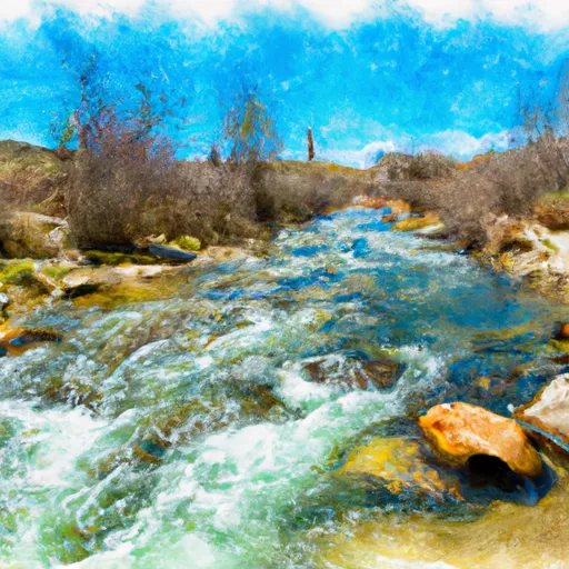
Raymond Creek
The class rating of Raymond Creek is class III-IV, which means that it is suitable for experienced paddlers who are comfortable with relatively challenging rapids, waves, and obstacles. Some of the specific rapids and obstacles on the creek include Pinball (a rapid with a challenging entrance and exit), The Room of Doom (a narrow, rocky section of the creek with several small drops), and The Squeeze (a narrow section of the creek with a tight turn).
There are some specific regulations and guidelines that paddlers should be aware of when visiting Raymond Creek. For example, it is recommended that paddlers wear a helmet and a personal flotation device at all times while on the creek. Additionally, paddlers should be familiar with the local water levels and weather conditions, as these factors can affect the safety and difficulty of the creek.
Overall, Raymond Creek is a challenging and rewarding whitewater river run that offers experienced paddlers a chance to test their skills and enjoy the beauty of Wyoming's rivers and landscapes.
Plan your run down to the hour
Same weather feed Snoflo's iOS app uses -- updated continuously from NOAA / yr.no. Watch the precipitation column on the meteogram; rain ahead of a run typically lifts flows 12-48 hours later depending on the basin.
Next 5 days, hour by hour
Temperature line with weather symbols on top, snow + rain accumulation as columns, humidity as a dotted line.
5-day forecast table
Every 3 hours, broken out across temperature, snow, rain, humidity, and wind. Each cell is colour-coded relative to the column min/max.
| Time | Condition | Temp (°F) | Snow (in) | Rain (in) | Humidity (%) | Wind (mps) | Wind dir |
|---|---|---|---|---|---|---|---|
| Loading detailed forecast… | |||||||
15-day temperature & precipitation
Daily temperatures, snow, and rain projected over the next two weeks -- the upstream story that drives next week's flows.
Regional streamflow levels
USGS streamgauges around Raymond Creek -- useful for spotting upstream pulses and gauging which tributary is contributing what.
| Streamgauge | Discharge | View |
|---|---|---|
| Bear River At Border | 75 cfs | → |
| Smiths Fork Near Border | 109 cfs | → |
| Bear River Below Smiths Fork | 120 cfs | → |
| Bear River At Pescadero | 1,330 cfs | → |
| Hams Fork Below Pole Creek | 29 cfs | → |
| Bear River Below Pixley Dam | 2 cfs | → |
Plan a longer trip
The closest boat launches, other paddle runs, and campgrounds so a day on the water can grow into a full weekend.
Other river runs
- Huff Creek
- Inlet To Marsh On Spring Creek To Outlet Of Marsh On Spring Creek
- Salt River Trailhead To Nf Boundary
- Source To Salt River Trailhead
- Source To Nf Boundary
Campgrounds
- Montpelier Canyon
- Montpelier Canyon Campground
- Montpellier Campground Canyon
- Kelley Guard Station
- Montpelier Creek Koa Journey
- Pine Creek Campsite 1
Parks
Whitewater safety
- Check the flow before you run
- Use the linked-gauge card and Regional Flow panel above. Class ratings change with flow -- a Class III at low water can become Class IV+ at high water.
- Know your skill ceiling
- Pick runs comfortably below your ceiling. Cold-water and big-water runs raise the consequences of any mistake.
- Wear the right gear
- Helmet, PFD, drysuit / wetsuit when water is below 60°F. Throw bag, knife, and whistle on your person, not in the boat.
- Scout, set safety, and run with a team
- Scout new rapids on foot, set safety with throw bags above the consequence pool, and run with at least one other competent paddler.
- Respect the river
- Strainers, undercuts, low-head dams, and wood can kill at any class rating. When in doubt, portage.
Set push alerts in the Snoflo app
Save Raymond Creek as a favorite, set a discharge threshold (e.g. "alert me when flow hits 600 cfs"), and the iOS app pushes the moment the linked gauge crosses.
About Raymond Creek
What's the optimal flow for Raymond Creek?
The optimal flow depends on the section and the craft. Check the Run Details panel for the linked gauge and current status.
How fresh is the cfs reading on this page?
The linked USGS streamgauge reports continuously (every 15 minutes); Snoflo refreshes throughout the day. Hover the streamflow sparkline to read individual datapoints.
What's the whitewater class?
See the Run Details panel for the class rating Snoflo tracks for this run. Class ratings change with flow -- a Class III at low water can become Class IV in high water.
Where do I put in / take out?
Tap Directions in the hero above to open driving directions to the put-in. For shuttle planning, check the Nearby Boat Launches panel and the river run operator's site.
Can I get alerts when flows hit the optimal range?
Yes -- alerts are managed in the Snoflo iOS app. Favorite this run, set a discharge threshold, and you'll get a push the moment the gauge crosses.
Other runs near here
Snoflo-tracked paddle runs within driving distance of Raymond Creek.