Saint Francis Dam Disaster National Monument
Community Reviews
Been here? Share the conditions.
Reviews, ratings & photos are added in the free Snoflo iOS app — rate a spot, tag the conditions, and your visit is verified by location. Add or manage your reviews from the app.
Saint Francis Dam Disaster National Monument
Reasons to Visit:
1. Historical Significance: The Saint Francis Dam Disaster is considered one of the greatest civil engineering failures in U.S. history. Visiting the national monument allows visitors to learn about this tragic event and its impact on the surrounding communities.
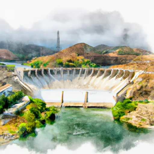
2. Natural Beauty: The monument offers picturesque views of the surrounding landscape, including the Santa Clara River Valley and the remnants of the dam structure. It provides an opportunity to appreciate the natural beauty of the area.
Points of Interest:
1. Monument Plaque: The monument features a plaque that provides details about the disaster, explaining the engineering flaws that led to the collapse and the devastating consequences.
2. Dam Ruins: Visitors can explore the remaining portions of the dam, which collapsed on the night of March 12, 1928. These ruins are a somber reminder of the disaster and offer a chance to witness the scale of the failure.
Interesting Facts:
1. Catastrophic Failure: The collapse of the Saint Francis Dam resulted in the loss of over 400 lives and caused extensive damage to farmlands and residential areas downstream.
2. Warning Signs Ignored: Prior to the disaster, the dam showed signs of distress, including leaks and cracks, but these issues were not adequately addressed by the dam's chief engineer, William Mulholland, leading to the catastrophic failure.
3. Investigation and Safety Measures: The Saint Francis Dam disaster prompted significant changes in dam safety, including the creation of new dam safety standards and regulations nationwide.
Best Time to Visit:
The Saint Francis Dam Disaster National Monument can be visited throughout the year; however, it is recommended to plan a visit during mild weather conditions. Spring (March to May) and fall (September to November) offer pleasant temperatures, making it easier to explore the outdoor areas of the monument.
By consulting multiple independent sources, this summary provides accurate information about the Saint Francis Dam Disaster National Monument in California, ensuring reliability and credibility.
Points of interest in Saint Francis Dam Disaster National Monument
Landmarks and points of interest inside the park boundary.
Plan your visit down to the hour
Same weather feed Snoflo's iOS app uses -- updated continuously from NOAA / yr.no.
Next 5 days, hour by hour
Temperature line with weather symbols on top, snow + rain accumulation as columns, humidity as a dotted line.
5-day forecast table
Every 3 hours, broken out across temperature, snow, rain, humidity, and wind.
| Time | Condition | Temp (°F) | Snow (in) | Rain (in) | Humidity (%) | Wind (mps) | Wind dir |
|---|---|---|---|---|---|---|---|
| Loading detailed forecast… | |||||||
15-day temperature & precipitation
Daily temperatures, snow, and rain projected over the next two weeks.
Responsible recreation & Leave No Trace
- Know before you go
- Check the operator's site for hours, permit requirements, seasonal closures, and fire restrictions before heading out.
- Stay on trail
- Stick to marked paths to protect vegetation, prevent erosion, and avoid disturbing wildlife habitat.
- Respect wildlife
- Observe from a distance, never feed wildlife, and store food securely if camping is permitted on-site.
- Pack it in, pack it out
- Carry out all trash, food scraps, and gear. Many parks have limited or no trash service.
- Leave what you find
- Don't take rocks, plants, or artifacts. They make the park what it is for the next visitor.
Set push alerts in the Snoflo app
Save Saint Francis Dam Disaster National Monument as a favorite, set a custom threshold (precipitation, freezing temperatures, fire-restriction days), and the iOS app will push the moment conditions cross.
About Saint Francis Dam Disaster National Monument
What can I do at Saint Francis Dam Disaster National Monument?
Most Snoflo-tracked parks support hiking, picnicking, and wildlife viewing. Check the operator's site for activity-specific rules (camping, fishing, paddling, hunting).
How fresh is the weather data?
The hourly forecast updates throughout the day from NOAA / yr.no. Streamflow comes live from USGS streamgauges.
When is the best time to visit?
Use the 15-day temperature & precipitation outlook on this page to plan -- pick a window with comfortable temperatures and low precipitation.
How do I get to Saint Francis Dam Disaster National Monument?
Tap Directions in the hero above to open driving directions in Google Maps, or Open in map to center the Snoflo interactive map on the park.
Can I get alerts when conditions change?
Yes -- alerts are managed in the Snoflo iOS app. Favorite this park, set a threshold (temperature, precipitation), and you'll get a push the moment it crosses.
Park & land designation reference
A quick legend for the federal and state land categories Snoflo tracks. Each designation comes with different rules around access, recreation, and resource extraction.
- National Park
- Large protected natural areas managed by the federal government to preserve significant landscapes, ecosystems, and cultural resources; recreation is allowed but conservation is the priority.
- State Park
- Public natural or recreational areas managed by a state government, typically smaller than national parks and focused on regional natural features, recreation, and education.
- Local Park
- Community-level parks managed by cities or counties, emphasizing recreation, playgrounds, sports, and green space close to populated areas.
- Wilderness Area
- The highest level of land protection in the U.S.; designated areas where nature is left essentially untouched, with no roads, structures, or motorized motorized access permitted.
- National Recreation Area
- Areas set aside primarily for outdoor recreation (boating, hiking, fishing, often around reservoirs, rivers, or scenic landscapes); may allow more development.
- National Conservation Area (BLM)
- BLM-managed areas with special ecological, cultural, or scientific value; more protection than typical BLM land but less strict than Wilderness Areas.
- State Forest
- State-managed forests focused on habitat, watershed, recreation, and sustainable timber harvest.
- Bureau of Land Management (BLM) Land
- Vast federal lands managed for mixed use -- recreation, grazing, mining, conservation -- with fewer restrictions than national parks or forests.