Sugarloaf Ridge State Park
Community Reviews
Been here? Share the conditions.
Reviews, ratings & photos are added in the free Snoflo iOS app — rate a spot, tag the conditions, and your visit is verified by location. Add or manage your reviews from the app.
Sugarloaf Ridge State Park
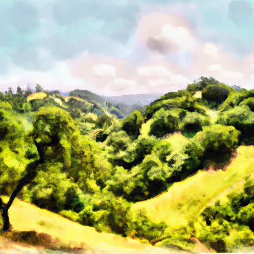
One of the main reasons to visit Sugarloaf Ridge State Park is its stunning natural beauty. The park is situated in the heart of the wine country, boasting rolling hills, lush forests, and meandering streams. The panoramic vistas from the park's trails, which include views of the surrounding valleys and the San Francisco Bay Area, are truly awe-inspiring.
A standout point of interest within the park is Bald Mountain, the highest peak in the area. Hiking to the summit of Bald Mountain rewards visitors with breathtaking views of the Sonoma Valley and the Pacific coastline. Another highlight is the 25-foot waterfall known as the "Falls of Sugarloaf," which is particularly majestic after heavy rains.
Sugarloaf Ridge State Park is also home to the Robert Ferguson Observatory, making it a unique destination for stargazing enthusiasts. The observatory offers regular public programs, allowing visitors to explore the night sky and learn about the wonders of astronomy.
Interesting facts about the area include its rich cultural history. The park's name is derived from the distinctive shape of its prominent rock formations, which resemble sugarloaf hats popular in the 17th century. Additionally, Sugarloaf Ridge State Park was one of the first parks in California to be purchased with bond funds approved by voters.
The best time of year to visit Sugarloaf Ridge State Park is during spring and fall. Spring brings vibrant wildflowers and pleasant temperatures, while autumn showcases a stunning display of foliage. Summers can be hot, so visitors are advised to bring plenty of water and sunscreen. Winter can also be a lovely time to visit, especially after rainfall when the streams and waterfall are at their most impressive.
To ensure accuracy, it is recommended to verify the information provided by consulting multiple independent sources such as the official park website, local tourism boards, and reputable travel guides.
Trails in Sugarloaf Ridge State Park
Named trails whose route falls inside the park.
Camping in Sugarloaf Ridge State Park
Campgrounds inside the park, with today's conditions score.

Plan your visit down to the hour
Same weather feed Snoflo's iOS app uses -- updated continuously from NOAA / yr.no.
Next 5 days, hour by hour
Temperature line with weather symbols on top, snow + rain accumulation as columns, humidity as a dotted line.
5-day forecast table
Every 3 hours, broken out across temperature, snow, rain, humidity, and wind.
| Time | Condition | Temp (°F) | Snow (in) | Rain (in) | Humidity (%) | Wind (mps) | Wind dir |
|---|---|---|---|---|---|---|---|
| Loading detailed forecast… | |||||||
15-day temperature & precipitation
Daily temperatures, snow, and rain projected over the next two weeks.
Responsible recreation & Leave No Trace
- Know before you go
- Check the operator's site for hours, permit requirements, seasonal closures, and fire restrictions before heading out.
- Stay on trail
- Stick to marked paths to protect vegetation, prevent erosion, and avoid disturbing wildlife habitat.
- Respect wildlife
- Observe from a distance, never feed wildlife, and store food securely if camping is permitted on-site.
- Pack it in, pack it out
- Carry out all trash, food scraps, and gear. Many parks have limited or no trash service.
- Leave what you find
- Don't take rocks, plants, or artifacts. They make the park what it is for the next visitor.
Set push alerts in the Snoflo app
Save Sugarloaf Ridge State Park as a favorite, set a custom threshold (precipitation, freezing temperatures, fire-restriction days), and the iOS app will push the moment conditions cross.
About Sugarloaf Ridge State Park
What can I do at Sugarloaf Ridge State Park?
Most Snoflo-tracked parks support hiking, picnicking, and wildlife viewing. Check the operator's site for activity-specific rules (camping, fishing, paddling, hunting).
How fresh is the weather data?
The hourly forecast updates throughout the day from NOAA / yr.no. Streamflow comes live from USGS streamgauges.
When is the best time to visit?
Use the 15-day temperature & precipitation outlook on this page to plan -- pick a window with comfortable temperatures and low precipitation.
How do I get to Sugarloaf Ridge State Park?
Tap Directions in the hero above to open driving directions in Google Maps, or Open in map to center the Snoflo interactive map on the park.
Can I get alerts when conditions change?
Yes -- alerts are managed in the Snoflo iOS app. Favorite this park, set a threshold (temperature, precipitation), and you'll get a push the moment it crosses.
Park & land designation reference
A quick legend for the federal and state land categories Snoflo tracks. Each designation comes with different rules around access, recreation, and resource extraction.
- National Park
- Large protected natural areas managed by the federal government to preserve significant landscapes, ecosystems, and cultural resources; recreation is allowed but conservation is the priority.
- State Park
- Public natural or recreational areas managed by a state government, typically smaller than national parks and focused on regional natural features, recreation, and education.
- Local Park
- Community-level parks managed by cities or counties, emphasizing recreation, playgrounds, sports, and green space close to populated areas.
- Wilderness Area
- The highest level of land protection in the U.S.; designated areas where nature is left essentially untouched, with no roads, structures, or motorized motorized access permitted.
- National Recreation Area
- Areas set aside primarily for outdoor recreation (boating, hiking, fishing, often around reservoirs, rivers, or scenic landscapes); may allow more development.
- National Conservation Area (BLM)
- BLM-managed areas with special ecological, cultural, or scientific value; more protection than typical BLM land but less strict than Wilderness Areas.
- State Forest
- State-managed forests focused on habitat, watershed, recreation, and sustainable timber harvest.
- Bureau of Land Management (BLM) Land
- Vast federal lands managed for mixed use -- recreation, grazing, mining, conservation -- with fewer restrictions than national parks or forests.