Community Reviews
Been here? Share the conditions.
Reviews, ratings & photos are added in the free Snoflo iOS app — rate a spot, tag the conditions, and your visit is verified by location. Add or manage your reviews from the app.
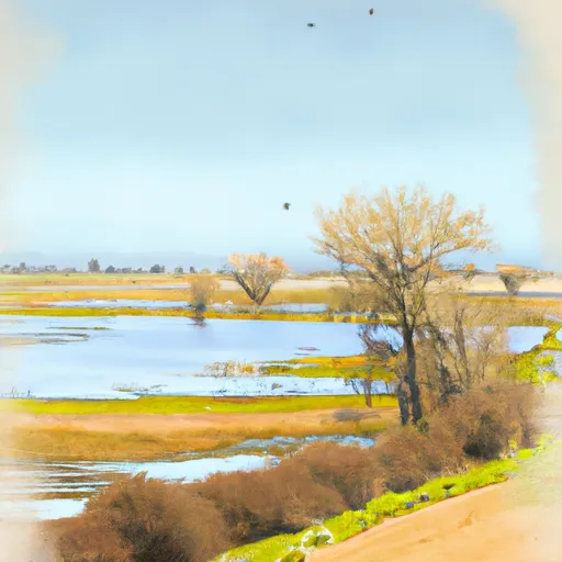
Sutter National Wildlife Refuge
One of the primary reasons to visit Sutter National Wildlife Refuge is the incredible bird-watching opportunities it presents. Over 200 bird species have been documented in the refuge, including waterfowl, shorebirds, raptors, and songbirds. The refuge's wetlands, riparian forests, and grasslands provide critical feeding and resting grounds for these birds during their migrations.
Several points of interest are worth exploring within the refuge. The Butte Sink Wildlife Management Area, managed in conjunction with Sutter National Wildlife Refuge, offers exceptional waterfowl hunting and is a popular area for experienced hunters. The Sutter Buttes, often called the "World's Smallest Mountain Range," can be seen from the refuge and provide a stunning backdrop for nature photography and hiking.
Interesting facts about Sutter National Wildlife Refuge include its contribution to the preservation of endangered species. The refuge has played a crucial role in the recovery of the giant garter snake, a threatened species endemic to California's Central Valley. Additionally, the Sutter National Wildlife Refuge was established in 1945 and has since expanded to encompass over 2,600 acres of protected land.
The best time of year to visit Sutter National Wildlife Refuge depends on personal preferences and interests. During the fall and winter months, the refuge becomes a temporary home to thousands of waterfowl, offering an excellent opportunity for birdwatching and observing migratory species. Spring and summer bring an explosion of wildflowers, butterflies, and other wildlife, creating a vibrant and colorful landscape.
To ensure accuracy, it is recommended to verify information about Sutter National Wildlife Refuge across multiple independent sources, such as the official website of the U.S. Fish and Wildlife Service, the agency responsible for managing the refuge.
Plan your visit down to the hour
Same weather feed Snoflo's iOS app uses -- updated continuously from NOAA / yr.no.
Next 5 days, hour by hour
Temperature line with weather symbols on top, snow + rain accumulation as columns, humidity as a dotted line.
5-day forecast table
Every 3 hours, broken out across temperature, snow, rain, humidity, and wind.
| Time | Condition | Temp (°F) | Snow (in) | Rain (in) | Humidity (%) | Wind (mps) | Wind dir |
|---|---|---|---|---|---|---|---|
| Loading detailed forecast… | |||||||
15-day temperature & precipitation
Daily temperatures, snow, and rain projected over the next two weeks.
Responsible recreation & Leave No Trace
- Know before you go
- Check the operator's site for hours, permit requirements, seasonal closures, and fire restrictions before heading out.
- Stay on trail
- Stick to marked paths to protect vegetation, prevent erosion, and avoid disturbing wildlife habitat.
- Respect wildlife
- Observe from a distance, never feed wildlife, and store food securely if camping is permitted on-site.
- Pack it in, pack it out
- Carry out all trash, food scraps, and gear. Many parks have limited or no trash service.
- Leave what you find
- Don't take rocks, plants, or artifacts. They make the park what it is for the next visitor.
Set push alerts in the Snoflo app
Save Sutter National Wildlife Refuge as a favorite, set a custom threshold (precipitation, freezing temperatures, fire-restriction days), and the iOS app will push the moment conditions cross.
About Sutter National Wildlife Refuge
What can I do at Sutter National Wildlife Refuge?
Most Snoflo-tracked parks support hiking, picnicking, and wildlife viewing. Check the operator's site for activity-specific rules (camping, fishing, paddling, hunting).
How fresh is the weather data?
The hourly forecast updates throughout the day from NOAA / yr.no. Streamflow comes live from USGS streamgauges.
When is the best time to visit?
Use the 15-day temperature & precipitation outlook on this page to plan -- pick a window with comfortable temperatures and low precipitation.
How do I get to Sutter National Wildlife Refuge?
Tap Directions in the hero above to open driving directions in Google Maps, or Open in map to center the Snoflo interactive map on the park.
Can I get alerts when conditions change?
Yes -- alerts are managed in the Snoflo iOS app. Favorite this park, set a threshold (temperature, precipitation), and you'll get a push the moment it crosses.
Park & land designation reference
A quick legend for the federal and state land categories Snoflo tracks. Each designation comes with different rules around access, recreation, and resource extraction.
- National Park
- Large protected natural areas managed by the federal government to preserve significant landscapes, ecosystems, and cultural resources; recreation is allowed but conservation is the priority.
- State Park
- Public natural or recreational areas managed by a state government, typically smaller than national parks and focused on regional natural features, recreation, and education.
- Local Park
- Community-level parks managed by cities or counties, emphasizing recreation, playgrounds, sports, and green space close to populated areas.
- Wilderness Area
- The highest level of land protection in the U.S.; designated areas where nature is left essentially untouched, with no roads, structures, or motorized motorized access permitted.
- National Recreation Area
- Areas set aside primarily for outdoor recreation (boating, hiking, fishing, often around reservoirs, rivers, or scenic landscapes); may allow more development.
- National Conservation Area (BLM)
- BLM-managed areas with special ecological, cultural, or scientific value; more protection than typical BLM land but less strict than Wilderness Areas.
- State Forest
- State-managed forests focused on habitat, watershed, recreation, and sustainable timber harvest.
- Bureau of Land Management (BLM) Land
- Vast federal lands managed for mixed use -- recreation, grazing, mining, conservation -- with fewer restrictions than national parks or forests.