Wyantenock State Forest-Coltsfoot Block
Community Reviews
Been here? Share the conditions.
Reviews, ratings & photos are added in the free Snoflo iOS app — rate a spot, tag the conditions, and your visit is verified by location. Add or manage your reviews from the app.
Wyantenock State Forest-Coltsfoot Block
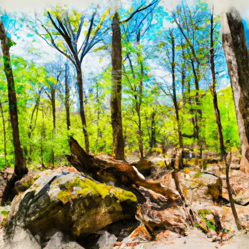
One of the primary attractions of Wyantenock State Forest-Coltsfoot Block is its stunning scenery. Visitors are treated to breathtaking views of rolling hills, dense forests, and meandering streams. The area is especially captivating during the fall season when the foliage transforms into a vibrant tapestry of red, orange, and gold.
Nature enthusiasts will find plenty to explore within the forest's boundaries. Hiking trails wind through the woods, providing opportunities for leisurely strolls or more challenging hikes. Along these trails, visitors can witness a variety of wildlife species, including deer, foxes, and various bird species. The forest is also home to Coltsfoot Bog, a unique wetland habitat that shelters rare plants and provides a haven for birdwatchers.
Wyantenock State Forest-Coltsfoot Block has its fair share of interesting facts. The forest covers an area of approximately 3,200 acres and is managed by the Connecticut Department of Energy and Environmental Protection. It is part of the larger Wyantenock State Forest, which comprises several other blocks in the surrounding region. The forest's name, Wyantenock, is derived from the Native American term meaning "crooked stream."
The best time of year to visit Wyantenock State Forest-Coltsfoot Block largely depends on personal preferences. Springtime offers an explosion of colorful wildflowers and budding trees, while summer allows for pleasant hikes and picnics. Fall is particularly enchanting due to the vibrant foliage, and winter transforms the forest into a serene wonderland for cross-country skiing and snowshoeing.
To ensure accuracy, it is recommended to refer to multiple independent sources, such as the official website of the Connecticut Department of Energy and Environmental Protection, local tourism websites, and reputable travel guides. These sources can provide additional detailed information regarding the forest's amenities, specific points of interest, and any seasonal restrictions or closures.
Plan your visit down to the hour
Same weather feed Snoflo's iOS app uses -- updated continuously from NOAA / yr.no.
Next 5 days, hour by hour
Temperature line with weather symbols on top, snow + rain accumulation as columns, humidity as a dotted line.
5-day forecast table
Every 3 hours, broken out across temperature, snow, rain, humidity, and wind.
| Time | Condition | Temp (°F) | Snow (in) | Rain (in) | Humidity (%) | Wind (mps) | Wind dir |
|---|---|---|---|---|---|---|---|
| Loading detailed forecast… | |||||||
15-day temperature & precipitation
Daily temperatures, snow, and rain projected over the next two weeks.
Responsible recreation & Leave No Trace
- Know before you go
- Check the operator's site for hours, permit requirements, seasonal closures, and fire restrictions before heading out.
- Stay on trail
- Stick to marked paths to protect vegetation, prevent erosion, and avoid disturbing wildlife habitat.
- Respect wildlife
- Observe from a distance, never feed wildlife, and store food securely if camping is permitted on-site.
- Pack it in, pack it out
- Carry out all trash, food scraps, and gear. Many parks have limited or no trash service.
- Leave what you find
- Don't take rocks, plants, or artifacts. They make the park what it is for the next visitor.
Set push alerts in the Snoflo app
Save Wyantenock State Forest-Coltsfoot Block as a favorite, set a custom threshold (precipitation, freezing temperatures, fire-restriction days), and the iOS app will push the moment conditions cross.
About Wyantenock State Forest-Coltsfoot Block
What can I do at Wyantenock State Forest-Coltsfoot Block?
Most Snoflo-tracked parks support hiking, picnicking, and wildlife viewing. Check the operator's site for activity-specific rules (camping, fishing, paddling, hunting).
How fresh is the weather data?
The hourly forecast updates throughout the day from NOAA / yr.no. Streamflow comes live from USGS streamgauges.
When is the best time to visit?
Use the 15-day temperature & precipitation outlook on this page to plan -- pick a window with comfortable temperatures and low precipitation.
How do I get to Wyantenock State Forest-Coltsfoot Block?
Tap Directions in the hero above to open driving directions in Google Maps, or Open in map to center the Snoflo interactive map on the park.
Can I get alerts when conditions change?
Yes -- alerts are managed in the Snoflo iOS app. Favorite this park, set a threshold (temperature, precipitation), and you'll get a push the moment it crosses.
Park & land designation reference
A quick legend for the federal and state land categories Snoflo tracks. Each designation comes with different rules around access, recreation, and resource extraction.
- National Park
- Large protected natural areas managed by the federal government to preserve significant landscapes, ecosystems, and cultural resources; recreation is allowed but conservation is the priority.
- State Park
- Public natural or recreational areas managed by a state government, typically smaller than national parks and focused on regional natural features, recreation, and education.
- Local Park
- Community-level parks managed by cities or counties, emphasizing recreation, playgrounds, sports, and green space close to populated areas.
- Wilderness Area
- The highest level of land protection in the U.S.; designated areas where nature is left essentially untouched, with no roads, structures, or motorized motorized access permitted.
- National Recreation Area
- Areas set aside primarily for outdoor recreation (boating, hiking, fishing, often around reservoirs, rivers, or scenic landscapes); may allow more development.
- National Conservation Area (BLM)
- BLM-managed areas with special ecological, cultural, or scientific value; more protection than typical BLM land but less strict than Wilderness Areas.
- State Forest
- State-managed forests focused on habitat, watershed, recreation, and sustainable timber harvest.
- Bureau of Land Management (BLM) Land
- Vast federal lands managed for mixed use -- recreation, grazing, mining, conservation -- with fewer restrictions than national parks or forests.