State Park Providence Canyon
Community Reviews
Been here? Share the conditions.
Reviews, ratings & photos are added in the free Snoflo iOS app — rate a spot, tag the conditions, and your visit is verified by location. Add or manage your reviews from the app.
State Park Providence Canyon
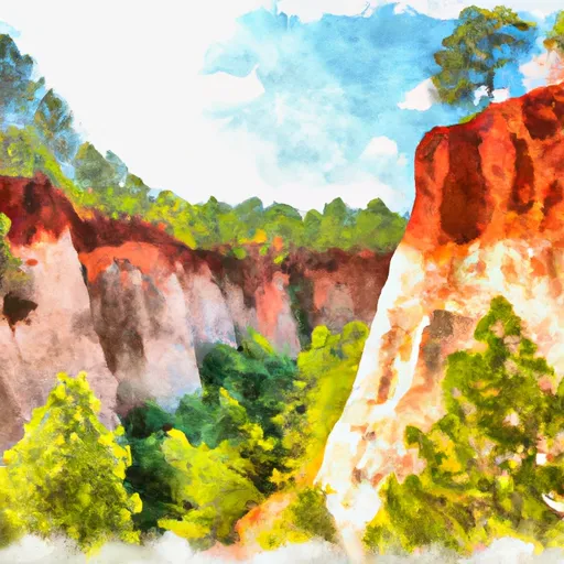
One of the primary reasons to visit Providence Canyon State Park is its breathtaking geological formations. The park is home to a series of vibrant and colorful canyons, which were formed through erosion caused by poor farming practices during the 19th century. The resulting deep gullies expose a range of stunning sedimentary layers, creating a visually stunning landscape that is unlike any other in Georgia.
Some specific points of interest within the park include:
1. The Canyon Loop Trail: This popular hiking trail provides visitors with an up-close and personal experience of the canyon's beauty. It stretches for approximately three miles and takes hikers through the heart of the park, offering panoramic views of the canyons and the surrounding woodlands.
2. The Visitor Center: The park's visitor center serves as an excellent starting point for any visit. Here, visitors can learn about the park's history, geology, and the ecological significance of the area. The center also provides maps, brochures, and knowledgeable staff who can offer guidance and assistance.
3. Picnic Areas: Providence Canyon State Park features multiple picnic areas where visitors can relax and enjoy a meal amidst the picturesque surroundings. These spots are equipped with picnic tables, grills, and restroom facilities, making them perfect for a family outing or a peaceful lunch in nature.
Interesting facts about Providence Canyon State Park:
1. The park spans over 1,000 acres, preserving and showcasing the natural beauty of the canyons.
2. The canyon walls vary in color, ranging from shades of pink and orange to vibrant reds and purples, creating a striking visual spectacle.
3. Providence Canyon is not a result of natural erosion, but rather a human-induced process caused by poor agricultural practices during the 1800s.
The best time of year to visit Providence Canyon State Park is during spring and fall. Springtime brings an explosion of wildflowers and blooming vegetation, while the fall season offers vibrant foliage and cooler temperatures for comfortable hiking. Summers in Georgia can be extremely hot, so visiting during this time may be less comfortable.
To ensure the accuracy of the information provided, it is recommended to verify details about Providence Canyon State Park by referring to multiple independent sources such as the official website of the Georgia State Parks and Historic Sites, travel guides, or reputable travel websites.
Trails in State Park Providence Canyon
Named trails whose route falls inside the park.
Plan your visit down to the hour
Same weather feed Snoflo's iOS app uses -- updated continuously from NOAA / yr.no.
Next 5 days, hour by hour
Temperature line with weather symbols on top, snow + rain accumulation as columns, humidity as a dotted line.
5-day forecast table
Every 3 hours, broken out across temperature, snow, rain, humidity, and wind.
| Time | Condition | Temp (°F) | Snow (in) | Rain (in) | Humidity (%) | Wind (mps) | Wind dir |
|---|---|---|---|---|---|---|---|
| Loading detailed forecast… | |||||||
15-day temperature & precipitation
Daily temperatures, snow, and rain projected over the next two weeks.
Responsible recreation & Leave No Trace
- Know before you go
- Check the operator's site for hours, permit requirements, seasonal closures, and fire restrictions before heading out.
- Stay on trail
- Stick to marked paths to protect vegetation, prevent erosion, and avoid disturbing wildlife habitat.
- Respect wildlife
- Observe from a distance, never feed wildlife, and store food securely if camping is permitted on-site.
- Pack it in, pack it out
- Carry out all trash, food scraps, and gear. Many parks have limited or no trash service.
- Leave what you find
- Don't take rocks, plants, or artifacts. They make the park what it is for the next visitor.
Set push alerts in the Snoflo app
Save State Park Providence Canyon as a favorite, set a custom threshold (precipitation, freezing temperatures, fire-restriction days), and the iOS app will push the moment conditions cross.
About State Park Providence Canyon
What can I do at State Park Providence Canyon?
Most Snoflo-tracked parks support hiking, picnicking, and wildlife viewing. Check the operator's site for activity-specific rules (camping, fishing, paddling, hunting).
How fresh is the weather data?
The hourly forecast updates throughout the day from NOAA / yr.no. Streamflow comes live from USGS streamgauges.
When is the best time to visit?
Use the 15-day temperature & precipitation outlook on this page to plan -- pick a window with comfortable temperatures and low precipitation.
How do I get to State Park Providence Canyon?
Tap Directions in the hero above to open driving directions in Google Maps, or Open in map to center the Snoflo interactive map on the park.
Can I get alerts when conditions change?
Yes -- alerts are managed in the Snoflo iOS app. Favorite this park, set a threshold (temperature, precipitation), and you'll get a push the moment it crosses.
Park & land designation reference
A quick legend for the federal and state land categories Snoflo tracks. Each designation comes with different rules around access, recreation, and resource extraction.
- National Park
- Large protected natural areas managed by the federal government to preserve significant landscapes, ecosystems, and cultural resources; recreation is allowed but conservation is the priority.
- State Park
- Public natural or recreational areas managed by a state government, typically smaller than national parks and focused on regional natural features, recreation, and education.
- Local Park
- Community-level parks managed by cities or counties, emphasizing recreation, playgrounds, sports, and green space close to populated areas.
- Wilderness Area
- The highest level of land protection in the U.S.; designated areas where nature is left essentially untouched, with no roads, structures, or motorized motorized access permitted.
- National Recreation Area
- Areas set aside primarily for outdoor recreation (boating, hiking, fishing, often around reservoirs, rivers, or scenic landscapes); may allow more development.
- National Conservation Area (BLM)
- BLM-managed areas with special ecological, cultural, or scientific value; more protection than typical BLM land but less strict than Wilderness Areas.
- State Forest
- State-managed forests focused on habitat, watershed, recreation, and sustainable timber harvest.
- Bureau of Land Management (BLM) Land
- Vast federal lands managed for mixed use -- recreation, grazing, mining, conservation -- with fewer restrictions than national parks or forests.