Wallops Island National Wildlife Refuge
Community Reviews
Been here? Share the conditions.
Reviews, ratings & photos are added in the free Snoflo iOS app — rate a spot, tag the conditions, and your visit is verified by location. Add or manage your reviews from the app.
Wallops Island National Wildlife Refuge
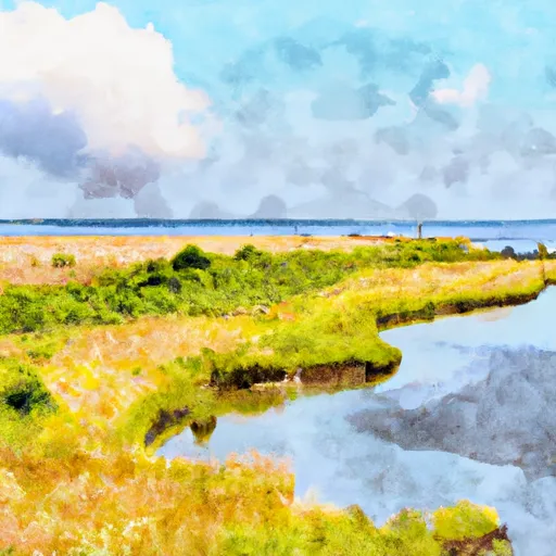
One primary reason to visit Wallops Island National Wildlife Refuge is its unparalleled natural beauty. The refuge boasts diverse habitats, including maritime forest, tidal marshes, dunes, and beach areas, providing a variety of landscapes to explore. The pristine beaches are particularly popular, offering visitors an opportunity to relax, swim, and enjoy the stunning coastal scenery.
The refuge is also renowned for its rich birdlife, making it a bird-watcher's paradise. Over 350 bird species have been recorded here, including a range of migratory species, shorebirds, waterfowl, and raptors. The spring and fall migration periods are especially exciting times to visit, as countless birds stop at the refuge during their journey. Several observation platforms and trails are available, enabling visitors to observe and photograph the diverse avian species.
Another point of interest within the refuge is the Education Center and Visitor Contact Station. Here, visitors can learn more about the local wildlife and ecosystems through informative displays, exhibits, and educational programs. The knowledgeable staff provides valuable insights into the refuge's conservation efforts and the importance of protecting its diverse flora and fauna.
Interesting facts about Wallops Island National Wildlife Refuge include its close proximity to the NASA Wallops Flight Facility. The refuge shares a boundary with this renowned spaceport, offering a unique blend of natural habitats and space exploration. Visitors may be fortunate enough to witness launches from the spaceport, providing an awe-inspiring experience.
The best time to visit the refuge depends on personal preferences and interests. Spring and fall are generally recommended since they coincide with the peak migration periods, offering abundant bird-watching opportunities. Additionally, these seasons provide pleasant weather and fewer crowds. However, the refuge is open year-round, and each season offers its own distinct beauty and wildlife sightings.
To ensure accuracy, it is advisable to verify the information provided by consulting multiple independent sources, such as the official website of the U.S. Fish and Wildlife Service and local tourism websites.
Plan your visit down to the hour
Same weather feed Snoflo's iOS app uses -- updated continuously from NOAA / yr.no.
Next 5 days, hour by hour
Temperature line with weather symbols on top, snow + rain accumulation as columns, humidity as a dotted line.
5-day forecast table
Every 3 hours, broken out across temperature, snow, rain, humidity, and wind.
| Time | Condition | Temp (°F) | Snow (in) | Rain (in) | Humidity (%) | Wind (mps) | Wind dir |
|---|---|---|---|---|---|---|---|
| Loading detailed forecast… | |||||||
15-day temperature & precipitation
Daily temperatures, snow, and rain projected over the next two weeks.
Responsible recreation & Leave No Trace
- Know before you go
- Check the operator's site for hours, permit requirements, seasonal closures, and fire restrictions before heading out.
- Stay on trail
- Stick to marked paths to protect vegetation, prevent erosion, and avoid disturbing wildlife habitat.
- Respect wildlife
- Observe from a distance, never feed wildlife, and store food securely if camping is permitted on-site.
- Pack it in, pack it out
- Carry out all trash, food scraps, and gear. Many parks have limited or no trash service.
- Leave what you find
- Don't take rocks, plants, or artifacts. They make the park what it is for the next visitor.
Set push alerts in the Snoflo app
Save Wallops Island National Wildlife Refuge as a favorite, set a custom threshold (precipitation, freezing temperatures, fire-restriction days), and the iOS app will push the moment conditions cross.
About Wallops Island National Wildlife Refuge
What can I do at Wallops Island National Wildlife Refuge?
Most Snoflo-tracked parks support hiking, picnicking, and wildlife viewing. Check the operator's site for activity-specific rules (camping, fishing, paddling, hunting).
How fresh is the weather data?
The hourly forecast updates throughout the day from NOAA / yr.no. Streamflow comes live from USGS streamgauges.
When is the best time to visit?
Use the 15-day temperature & precipitation outlook on this page to plan -- pick a window with comfortable temperatures and low precipitation.
How do I get to Wallops Island National Wildlife Refuge?
Tap Directions in the hero above to open driving directions in Google Maps, or Open in map to center the Snoflo interactive map on the park.
Can I get alerts when conditions change?
Yes -- alerts are managed in the Snoflo iOS app. Favorite this park, set a threshold (temperature, precipitation), and you'll get a push the moment it crosses.
Park & land designation reference
A quick legend for the federal and state land categories Snoflo tracks. Each designation comes with different rules around access, recreation, and resource extraction.
- National Park
- Large protected natural areas managed by the federal government to preserve significant landscapes, ecosystems, and cultural resources; recreation is allowed but conservation is the priority.
- State Park
- Public natural or recreational areas managed by a state government, typically smaller than national parks and focused on regional natural features, recreation, and education.
- Local Park
- Community-level parks managed by cities or counties, emphasizing recreation, playgrounds, sports, and green space close to populated areas.
- Wilderness Area
- The highest level of land protection in the U.S.; designated areas where nature is left essentially untouched, with no roads, structures, or motorized motorized access permitted.
- National Recreation Area
- Areas set aside primarily for outdoor recreation (boating, hiking, fishing, often around reservoirs, rivers, or scenic landscapes); may allow more development.
- National Conservation Area (BLM)
- BLM-managed areas with special ecological, cultural, or scientific value; more protection than typical BLM land but less strict than Wilderness Areas.
- State Forest
- State-managed forests focused on habitat, watershed, recreation, and sustainable timber harvest.
- Bureau of Land Management (BLM) Land
- Vast federal lands managed for mixed use -- recreation, grazing, mining, conservation -- with fewer restrictions than national parks or forests.